TopoQuest Logo
Do you find TopoQuest useful?
Help keep TopoQuest running and adding new maps/features by donating!
Bitcoin:  19c7KJd3qBynnjoSw5npx9KScwjBe4ifkT
Litecoin:  LXs6TkuXGGXo1vDsWCkWVdjQX94eUKd6ui
Home View Maps Find Maps Find Places Resources & Links


Waterloo, Illinois Topographic Map

USGS Map Title: Waterloo, IL
USGS Map MRC: 38090C2
DRG (GeoTIFF) Download: o38090c2.tif


Neighboring USGS Topographic Map Quads:


  Oakville, MO  
38090D3
 

  Columbia, IL  
38090D2
 

  Millstadt, IL  
38090D1
 

  Valmeyer, IL  
38090C3
 

  Waterloo, IL  
38090C2
 

  Paderborn, IL  
38090C1
 

  Selma, MO  
38090B3
 

  Renault, IL  
38090B2
 

  Ames, IL  
38090B1


Map MRC Location:

N39°
W91°
N39°
W90°
H8 H7 H6 H5 H4 H3 H2 H1
G8 G7 G6 G5 G4 G3 G2 G1
F8 F7 F6 F5 F4 F3 F2 F1
E8 E7 E6 E5 E4 E3 E2 E1
D8 D7 D6 D5 D4 D3 D2 D1
C8 C7 C6 C5 C4 C3 C2 C1
B8 B7 B6 B5 B4 B3 B2 B1
A8 A7 A6 A5 A4 A3 A2 A1
N38°
W91°
N38°
W90°

Waterloo, IL USGS 1:24K Topographic Map Preview:
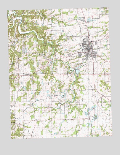
Waterloo, IL USGS Topographic Map
Click on map above to begin viewing in our Map Viewer.

This topographic map contains these locations and features:
Feature Name Type Latitude Longitude GNIS ID View Map
Andys RunStreamN38.3689°W90.2351°403522View Map
Baum School (historical)SchoolN38.2892°W90.2198°1821644View Map
Beaver LakeLakeN38.2875°W90.1820°404063View Map
Bissell LakeLakeN38.2951°W90.2028°404479View Map
Bond CreekStreamN38.3670°W90.2387°404673View Map
BurksvillePopulated PlaceN38.2673°W90.1526°405228View Map
Burksville CemeteryCemeteryN38.2681°W90.1607°423450View Map
Burksville School (historical)SchoolN38.2728°W90.1554°1821651View Map
Camp VanderventerLocaleN38.3417°W90.2046°405509View Map
Camp WartburgLocaleN38.2839°W90.1921°423449View Map
Church of GodChurchN38.3081°W90.2421°423445View Map
City of WaterlooCivilN38.3402°W90.1538°2397210View Map
Concord Presbyterian ChurchChurchN38.3548°W90.1534°423441View Map
Copp School (historical)SchoolN38.3545°W90.1915°1821659View Map
Deer Hill CemeteryCemeteryN38.3334°W90.2348°423440View Map
Deer Hill ChurchChurchN38.3626°W90.2371°423439View Map
Deer Hill School (historical)SchoolN38.3331°W90.2290°1821660View Map
Dry RunStreamN38.2501°W90.1382°407434View Map
Election Precinct 12CivilN38.2886°W90.2039°1928607View Map
Election Precinct 16CivilN38.3493°W90.1592°1928610View Map
Election Precinct 17CivilN38.3363°W90.1643°1928611View Map
Election Precinct 18CivilN38.3251°W90.1539°1928612View Map
Election Precinct 19CivilN38.3311°W90.1440°1928613View Map
Election Precinct 22CivilN38.3329°W90.2130°1928617View Map
Election Precinct 26CivilN38.3434°W90.1321°1928621View Map
Election Precinct 27CivilN38.3143°W90.1642°1928622View Map
First Baptist Church of WaterlooChurchN38.3320°W90.1548°1821662View Map
First ChurchChurchN38.3281°W90.1407°423444View Map
Foster PondLakeN38.3123°W90.2329°408569View Map
Foster Pond (historical)Populated PlaceN38.3117°W90.2276°423588View Map
Fox LakeLakeN38.2937°W90.1829°408626View Map
Gibault High SchoolSchoolN38.3445°W90.1571°423442View Map
Hesterburg CreekStreamN38.2839°W90.1765°410122View Map
Holy Cross CemeteryCemeteryN38.2903°W90.1984°423451View Map
Holy Cross ChurchChurchN38.2889°W90.1971°1821669View Map
Holy Cross SchoolSchoolN38.2895°W90.1973°423590View Map
Immanuel Lutheran ChurchChurchN38.3295°W90.1501°1821673View Map
Island LakeLakeN38.3630°W90.1461°410966View Map
Johanna Church (historical)ChurchN38.3328°W90.2354°1821675View Map
Kolmer CemeteryCemeteryN38.3406°W90.1468°411600View Map
Lake LoudelReservoirN38.2992°W90.2314°1691583View Map
Lake Loudel DamDamN38.3001°W90.2301°1691582View Map
Lemen CemeteryCemeteryN38.2898°W90.1490°423447View Map
LemensPopulated PlaceN38.2826°W90.1421°1821679View Map
MadonnavillePopulated PlaceN38.2651°W90.2468°412840View Map
Monroe CountyCivilN38.2786°W90.1774°1784865View Map
Monroe County AmbulanceBuildingN38.3393°W90.1630°2673768View Map
Monroe County CourthouseBuildingN38.3356°W90.1498°1821689View Map
Monroe County Fire DepartmentBuildingN38.3356°W90.1474°2468042View Map
Monroe County Sheriff’s DepartmentBuildingN38.3358°W90.1470°2759117View Map
Moores CemeteryCemeteryN38.3231°W90.1493°423446View Map
Morrison-Talbott LibraryBuildingN38.3328°W90.1526°1821690View Map
New Design Historical CemeteryCemeteryN38.2823°W90.1312°423448View Map
Old Rock SchoolSchoolN38.2681°W90.2021°415049View Map
Precinct 30 Election PrecinctCivilN38.3693°W90.1635°1952850View Map
Precinct 31 Election PrecinctCivilN38.3398°W90.1514°1952855View Map
Precinct 32 Election PrecinctCivilN38.3355°W90.1529°1952856View Map
Precinct 33 Election PrecinctCivilN38.3222°W90.1438°1952857View Map
Saint Johns Church (historical)ChurchN38.3337°W90.2343°423596View Map
Saints Peter and Paul Catholic ChurchChurchN38.3356°W90.1521°1821702View Map
Saints Peter and Paul CemeteryCemeteryN38.3334°W90.1640°417085View Map
Salem ChurchChurchN38.2889°W90.2209°417868View Map
Schmeltz Stock FarmLocaleN38.3114°W90.1797°2680997View Map
Schroeder School (historical)SchoolN38.3684°W90.1271°1821705View Map
The Church of Jesus Christ of Latter Day SaintsChurchN38.3312°W90.1665°1821652View Map
Timber LakeLakeN38.2686°W90.1465°423438View Map
Twin LakesLakeN38.2948°W90.1937°419980View Map
W J Zahnow Elementary SchoolSchoolN38.3426°W90.1479°423443View Map
WartburgPopulated PlaceN38.2906°W90.1957°420544View Map
WaterlooPopulated PlaceN38.3359°W90.1498°420634View Map
Waterloo Community Rural Fire Protection DistrictBuildingN38.3380°W90.1563°2467675View Map
Waterloo High SchoolSchoolN38.3384°W90.1468°1821712View Map
Waterloo Historic DistrictParkN38.3345°W90.1496°1821713View Map
Waterloo Junior High SchoolSchoolN38.3389°W90.1473°1821714View Map
Waterloo New ReservoirReservoirN38.3137°W90.1655°1691270View Map
Waterloo New Reservoir DamDamN38.3151°W90.1668°1691269View Map
Waterloo Police DepartmentBuildingN38.3337°W90.1502°2758874View Map
Waterloo Post OfficePost OfficeN38.3362°W90.1453°1821715View Map
Waterloo Reservoir Number 1ReservoirN38.3171°W90.1664°1691264View Map
Waterloo Reservoir Number 1 DamDamN38.3167°W90.1668°1691263View Map
Waterloo Reservoir Number 2ReservoirN38.3181°W90.1623°1692168View Map
Waterloo Reservoir Number 2 DamDamN38.3184°W90.1651°1692167View Map

Note: Coordinates in the location and feature list above are referenced to NAD83 datum.


Copyright (C) 2008-2024 Ryan Niemi / Sunset Dynamics ... All Rights Reserved