TopoQuest Logo
Do you find TopoQuest useful?
Help keep TopoQuest running and adding new maps/features by donating!
Bitcoin:  19c7KJd3qBynnjoSw5npx9KScwjBe4ifkT
Litecoin:  LXs6TkuXGGXo1vDsWCkWVdjQX94eUKd6ui
Home View Maps Find Maps Find Places Resources & Links


Millstadt, Illinois Topographic Map

USGS Map Title: Millstadt, IL
USGS Map MRC: 38090D1
DRG (GeoTIFF) Download: o38090d1.tif


Neighboring USGS Topographic Map Quads:


  Cahokia, IL  
38090E2
 

  French Village, IL  
38090E1
 

  O'Fallon, IL  
38089E8
 

  Columbia, IL  
38090D2
 

  Millstadt, IL  
38090D1
 

  Freeburg, IL  
38089D8
 

  Waterloo, IL  
38090C2
 

  Paderborn, IL  
38090C1
 

  New Athens West, IL  
38089C8


Map MRC Location:

N39°
W91°
N39°
W90°
H8 H7 H6 H5 H4 H3 H2 H1
G8 G7 G6 G5 G4 G3 G2 G1
F8 F7 F6 F5 F4 F3 F2 F1
E8 E7 E6 E5 E4 E3 E2 E1
D8 D7 D6 D5 D4 D3 D2 D1
C8 C7 C6 C5 C4 C3 C2 C1
B8 B7 B6 B5 B4 B3 B2 B1
A8 A7 A6 A5 A4 A3 A2 A1
N38°
W91°
N38°
W90°

Millstadt, IL USGS 1:24K Topographic Map Preview:
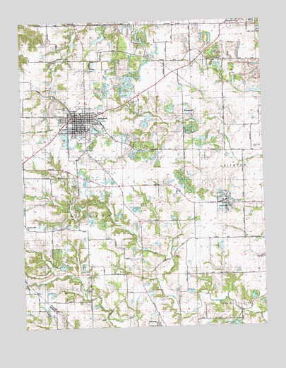
Millstadt, IL USGS Topographic Map
Click on map above to begin viewing in our Map Viewer.

This topographic map contains these locations and features:
Feature Name Type Latitude Longitude GNIS ID View Map
Abundant Life ChurchChurchN38.4548°W90.1062°426095View Map
Beil Lake Number 1 East DamDamN38.4617°W90.0568°1691970View Map
Beil Lake Number 1 East ReservoirReservoirN38.4617°W90.0568°1691971View Map
Beil Lake Number 1 North Dam Number 2DamN38.4617°W90.0584°1692170View Map
Beil Lake Number 1 North Dam Number 2ReservoirN38.4604°W90.0589°1692171View Map
Beil Lake Number 2ReservoirN38.4578°W90.0612°1691421View Map
Beil Lake Number 2 DamDamN38.4584°W90.0584°1691420View Map
BohleysvillePopulated PlaceN38.4153°W90.1187°426276View Map
Commercial Club ParkParkN38.4645°W90.0946°426091View Map
Concordia CemeteryCemeteryN38.4992°W90.0954°426098View Map
Concordia ChurchChurchN38.4995°W90.0959°426306View Map
Dayton School (historical)SchoolN38.4162°W90.1232°1821806View Map
Diamond Joe MineMineN38.4489°W90.0668°1821807View Map
Eckert School (historical)SchoolN38.4326°W90.0646°1821816View Map
Fairview School (historical)SchoolN38.4984°W90.0640°1821819View Map
FloravillePopulated PlaceN38.3764°W90.0562°426341View Map
Floraville Census Designated PlaceCensusN38.3763°W90.0553°2583438View Map
Foley ParkParkN38.4270°W90.0215°426100View Map
Freivogel CemeteryCemeteryN38.4331°W90.0965°426582View Map
Gateway ChurchChurchN38.4587°W90.1009°426094View Map
High Prairie CemeteryCemeteryN38.4253°W90.0115°426367View Map
High Prairie School (historical)SchoolN38.4251°W90.0123°1821828View Map
Illinois No Name Number 362 DamDamN38.4684°W90.0684°1691417View Map
MillstadtPopulated PlaceN38.4614°W90.0918°426434View Map
Millstadt Ambulance ServiceBuildingN38.4603°W90.0915°2640506View Map
Millstadt Fire DepartmentBuildingN38.4601°W90.0913°2640435View Map
Millstadt Post OfficePost OfficeN38.4596°W90.0926°1821886View Map
Millstadt Sewage Treatment PlantLocaleN38.4567°W90.0857°2469071View Map
Millstadt Sportsmans Club LakeReservoirN38.4513°W90.0319°1691419View Map
Millstadt Sportsmans Club Lake DamDamN38.4501°W90.0301°1691418View Map
Mount Evergreen CemeteryCemeteryN38.4642°W90.1007°426437View Map
New West Fork Club LakeReservoirN38.3870°W90.0070°1691429View Map
New West Fork Club Lake DamDamN38.3851°W90.0068°1691428View Map
Oak Ridge FarmLocaleN38.3950°W90.0792°2662806View Map
Oakdale School (historical)SchoolN38.4664°W90.1234°1821876View Map
Old Millstadt CemeteryCemeteryN38.4545°W90.0923°426096View Map
RoachtownPopulated PlaceN38.4631°W90.0409°426486View Map
Roachtown LakeReservoirN38.4636°W90.0475°1691396View Map
Roachtown Lake DamDamN38.4617°W90.0451°1691395View Map
Saint Clair County Farm and Nature ParkParkN38.4231°W90.0207°426101View Map
Saint James CemeteryCemeteryN38.4803°W90.0909°426502View Map
Saint James ChurchChurchN38.4612°W90.0962°426093View Map
Saint James SchoolSchoolN38.4612°W90.0965°426092View Map
Saint Pauls ChurchChurchN38.3756°W90.0576°426102View Map
Saxtown CemeteryCemeteryN38.3900°W90.0909°426521View Map
Saxtown School (historical)SchoolN38.4039°W90.0737°1821888View Map
Smithton Sportmans Club LakeReservoirN38.3756°W90.0160°1691392View Map
Smithton Sportmans Club Lake DamDamN38.3767°W90.0168°1691391View Map
Sportsman LakeLakeN38.3752°W90.0145°426537View Map
Stein-Nagel CemeteryCemeteryN38.4478°W90.0048°426099View Map
Stookey SchoolSchoolN38.4984°W90.0207°426543View Map
Township of MillstadtCivilN38.4230°W90.0839°429370View Map
Trinity ChurchChurchN38.4626°W90.0854°426090View Map
Union Hill CemeteryCemeteryN38.4667°W90.0682°426561View Map
Union School (historical)SchoolN38.4470°W90.0412°1821895View Map
Village of MillstadtCivilN38.4592°W90.0837°2399363View Map
Vogel School (historical)SchoolN38.3787°W90.0879°1821897View Map
West Prairie School (historical)SchoolN38.4639°W90.0012°1821901View Map
White School (historical)SchoolN38.4737°W90.0548°1821903View Map
YMCA Camp LakeReservoirN38.4812°W90.0220°1691394View Map
YMCA Camp Lake DamDamN38.4801°W90.0218°1691393View Map
Zion Fellowship ParkParkN38.4539°W90.0896°426097View Map

Note: Coordinates in the location and feature list above are referenced to NAD83 datum.


Copyright (C) 2008-2024 Ryan Niemi / Sunset Dynamics ... All Rights Reserved