TopoQuest Logo
Do you find TopoQuest useful?
Help keep TopoQuest running and adding new maps/features by donating!
Bitcoin:  19c7KJd3qBynnjoSw5npx9KScwjBe4ifkT
Litecoin:  LXs6TkuXGGXo1vDsWCkWVdjQX94eUKd6ui
Home View Maps Find Maps Find Places Resources & Links


Weisner Mountain, Alabama Topographic Map

USGS Map Title: Weisner Mountain, AL
USGS Map MRC: 34085A6
DRG (GeoTIFF) Download: o34085a6.tif


Neighboring USGS Topographic Map Quads:


  Leesburg, AL  
34085B7
 

  Centre, AL  
34085B6
 

  Cedar Bluff, AL  
34085B5
 

  Ballplay, AL  
34085A7
 

  Weisner Mountain, AL  
34085A6
 

  Ellisville, AL  
34085A5
 

  Colvin Gap, AL  
33085H7
 

  Piedmont NW, AL  
33085H6
 

  Piedmont, AL  
33085H5


Map MRC Location:

N35°
W86°
N35°
W85°
H8 H7 H6 H5 H4 H3 H2 H1
G8 G7 G6 G5 G4 G3 G2 G1
F8 F7 F6 F5 F4 F3 F2 F1
E8 E7 E6 E5 E4 E3 E2 E1
D8 D7 D6 D5 D4 D3 D2 D1
C8 C7 C6 C5 C4 C3 C2 C1
B8 B7 B6 B5 B4 B3 B2 B1
A8 A7 A6 A5 A4 A3 A2 A1
N34°
W86°
N34°
W85°

Weisner Mountain, AL USGS 1:24K Topographic Map Preview:
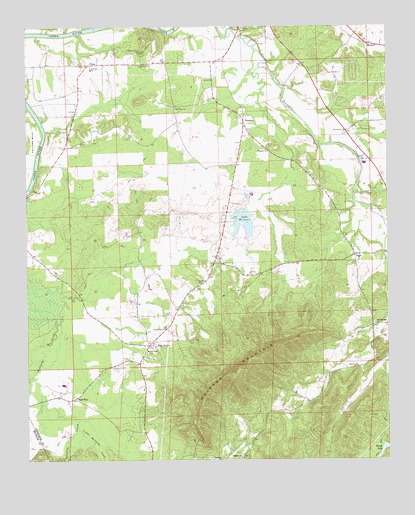
Weisner Mountain, AL USGS Topographic Map
Click on map above to begin viewing in our Map Viewer.

This topographic map contains these locations and features:
Feature Name Type Latitude Longitude GNIS ID View Map
Antioch Church of ChristChurchN34.0270°W85.6355°155849View Map
Ball FlatPopulated PlaceN34.0179°W85.7339°156016View Map
Centre DivisionCivilN34.0733°W85.6653°165687View Map
Cherokee Country ClubLocaleN34.1112°W85.6527°136861View Map
Davis Chapel CemeteryCemeteryN34.0312°W85.7083°136878View Map
Davis Chapel Methodist ChurchChurchN34.0309°W85.7089°155863View Map
Lake WeisnerReservoirN34.0701°W85.6757°128711View Map
Lighthouse ChurchChurchN34.0912°W85.6764°1699998View Map
Little Ballplay CreekStreamN34.0090°W85.7325°121687View Map
Melrose Baptist ChurchChurchN34.1126°W85.7272°155883View Map
Morrison CemeteryCemeteryN34.0951°W85.7355°136932View Map
Morrison CreekStreamN34.0468°W85.7300°136933View Map
Mount Davis Community CenterBuildingN34.0287°W85.7102°164461View Map
Mount Olive CemeteryCemeteryN34.0509°W85.6911°136938View Map
Mount Olive CemeteryCemeteryN34.1006°W85.6983°136939View Map
Mount Olive ChurchChurchN34.1015°W85.6977°123322View Map
Mount Weisner Volunteer Fire DepartmentBuildingN34.0421°W85.7114°2682869View Map
Mountain SpringSpringN34.0395°W85.6300°149266View Map
Mountain Springs CemeteryCemeteryN34.0398°W85.6300°136944View Map
Mountain Springs Methodist ChurchChurchN34.0393°W85.6294°155891View Map
Parker Grove CemeteryCemeteryN34.1179°W85.7097°152844View Map
Parkers Grove Methodist ChurchChurchN34.1140°W85.7102°155897View Map
Pine GrovePopulated PlaceN34.0332°W85.7077°124772View Map
PlanoPopulated PlaceN34.1143°W85.7275°124927View Map
PopePopulated PlaceN34.0587°W85.6366°156918View Map
Providence Baptist ChurchChurchN34.0951°W85.6389°153085View Map
Providence CemeteryCemeteryN34.0951°W85.6386°136964View Map
Ricks (historical)Populated PlaceN34.0590°W85.6836°136966View Map
Sardis Hill CemeteryCemeteryN34.0381°W85.7019°136975View Map
Sardis Hill Missionary Baptist ChurchChurchN34.0379°W85.7025°153340View Map
Tabernacle of Life ChurchChurchN34.0551°W85.6769°136988View Map
TennalaPopulated PlaceN34.0979°W85.6744°127757View Map
Tennala Baptist ChurchChurchN34.0890°W85.6661°127758View Map
Weaver CemeteryCemeteryN34.0918°W85.7269°137003View Map
Weisner DamDamN34.0718°W85.6716°131929View Map
Weisner MountainSummitN34.0265°W85.6744°128710View Map
Woods LakeReservoirN34.0033°W85.6267°154033View Map

Note: Coordinates in the location and feature list above are referenced to NAD83 datum.


Copyright (C) 2008-2024 Ryan Niemi / Sunset Dynamics ... All Rights Reserved