TopoQuest Logo
Do you find TopoQuest useful?
Help keep TopoQuest running and adding new maps/features by donating!
Bitcoin:  19c7KJd3qBynnjoSw5npx9KScwjBe4ifkT
Litecoin:  LXs6TkuXGGXo1vDsWCkWVdjQX94eUKd6ui
Home View Maps Find Maps Find Places Resources & Links


Wellville, Virginia Topographic Map

USGS Map Title: Wellville, VA
USGS Map MRC: 37077B8
DRG (GeoTIFF) Download: o37077b8.tif


Neighboring USGS Topographic Map Quads:


  Jetersville, VA  
37078C1
 

  Amelia Court House, VA  
37077C8
 

  Mannboro, VA  
37077C7
 

  Crewe East, VA  
37078B1
 

  Wellville, VA  
37077B8
 

  Hebron, VA  
37077B7
 

  Blackstone West, VA  
37078A1
 

  Blackstone East, VA  
37077A8
 

  Darvills, VA  
37077A7


Map MRC Location:

N38°
W78°
N38°
W77°
H8 H7 H6 H5 H4 H3 H2 H1
G8 G7 G6 G5 G4 G3 G2 G1
F8 F7 F6 F5 F4 F3 F2 F1
E8 E7 E6 E5 E4 E3 E2 E1
D8 D7 D6 D5 D4 D3 D2 D1
C8 C7 C6 C5 C4 C3 C2 C1
B8 B7 B6 B5 B4 B3 B2 B1
A8 A7 A6 A5 A4 A3 A2 A1
N37°
W78°
N37°
W77°

Wellville, VA USGS 1:24K Topographic Map Preview:
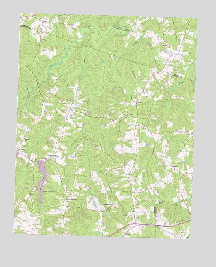
Wellville, VA USGS Topographic Map
Click on map above to begin viewing in our Map Viewer.

This topographic map contains these locations and features:
Feature Name Type Latitude Longitude GNIS ID View Map
Belle Fonte ChurchChurchN37.1621°W77.9194°1463037View Map
Belle Fonte Grange Hall (historical)BuildingN37.1607°W77.9200°1493890View Map
Bethel CemeteryCemeteryN37.1779°W77.9942°1493891View Map
Bethel ChurchChurchN37.1782°W77.9942°1463173View Map
Bland CreekStreamN37.2165°W77.9564°1463552View Map
Cedar Hill ChurchChurchN37.1943°W77.9228°1464626View Map
Cellar CreekLocaleN37.1718°W77.9986°1464659View Map
Cellar CreekStreamN37.2404°W77.9408°1464660View Map
Cellar Creek ChurchChurchN37.1710°W77.9989°1493905View Map
Clays CornerPopulated PlaceN37.1963°W77.9628°1499269View Map
Colemans StoreLocaleN37.1699°W77.9714°1465095View Map
Daniels DamDamN37.1435°W77.9331°1490517View Map
Davis DamDamN37.1818°W77.9097°1490518View Map
DenaroPopulated PlaceN37.2452°W77.9842°1499334View Map
District 4CivilN37.1643°W77.9291°1927249View Map
EarlsPopulated PlaceN37.2302°W77.8931°1499368View Map
Greensville Volunteer Rescue SquadBuildingN37.1394°W77.9125°2086227View Map
Hawkes StoreLocaleN37.1432°W77.9308°1467842View Map
Hawks BranchStreamN37.2379°W77.9139°1467848View Map
Hobbs Mill (historical)LocaleN37.1649°W77.8803°1690057View Map
Jerusalem ChurchChurchN37.1663°W77.8897°1468703View Map
Jerusalem School (historical)SchoolN37.1599°W77.8894°1493923View Map
Lake LeeReservoirN37.1442°W77.9808°1490500View Map
Lake Lee DamDamN37.1668°W77.9831°1490499View Map
Lees CreekStreamN37.1757°W77.9847°1469278View Map
Little CreekStreamN37.2340°W77.9653°1469518View Map
Luthers BranchStreamN37.1649°W77.9472°1469940View Map
North WellvillePopulated PlaceN37.1504°W77.9169°1477580View Map
Pattersons StoreLocaleN37.1457°W77.9625°1472115View Map
Poplar Lawn ChurchChurchN37.1379°W77.9208°1472655View Map
Poplar Lawn School (historical)SchoolN37.1260°W77.9225°1493931View Map
Rocky Hill ChurchChurchN37.2021°W77.9156°1473460View Map
Simentons StoreLocaleN37.2010°W77.9614°1474604View Map
SpainvillePopulated PlaceN37.1888°W77.9161°1477774View Map
WellvillePopulated PlaceN37.1274°W77.9208°1477867View Map
Woody CreekStreamN37.2082°W77.9889°1476984View Map
WSVS-FM (Crewe)TowerN37.1710°W77.9542°1502627View Map

Note: Coordinates in the location and feature list above are referenced to NAD83 datum.


Copyright (C) 2008-2024 Ryan Niemi / Sunset Dynamics ... All Rights Reserved