TopoQuest Logo
Do you find TopoQuest useful?
Help keep TopoQuest running and adding new maps/features by donating!
Bitcoin:  19c7KJd3qBynnjoSw5npx9KScwjBe4ifkT
Litecoin:  LXs6TkuXGGXo1vDsWCkWVdjQX94eUKd6ui
Home View Maps Find Maps Find Places Resources & Links


Yorkville SE, Illinois Topographic Map

USGS Map Title: Yorkville SE, IL
USGS Map MRC: 41088E3
DRG (GeoTIFF) Download: o41088e3.tif


Neighboring USGS Topographic Map Quads:


  Yorkville, IL  
41088F4
 

  Aurora South, IL  
41088F3
 

  Normantown, IL  
41088F2
 

  Plattville, IL  
41088E4
 

  Yorkville SE, IL  
41088E3
 

  Plainfield, IL  
41088E2
 

  Lisbon, IL  
41088D4
 

  Minooka, IL  
41088D3
 

  Channahon, IL  
41088D2


Map MRC Location:

N42°
W89°
N42°
W88°
H8 H7 H6 H5 H4 H3 H2 H1
G8 G7 G6 G5 G4 G3 G2 G1
F8 F7 F6 F5 F4 F3 F2 F1
E8 E7 E6 E5 E4 E3 E2 E1
D8 D7 D6 D5 D4 D3 D2 D1
C8 C7 C6 C5 C4 C3 C2 C1
B8 B7 B6 B5 B4 B3 B2 B1
A8 A7 A6 A5 A4 A3 A2 A1
N41°
W89°
N41°
W88°

Yorkville SE, IL USGS 1:24K Topographic Map Preview:
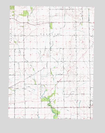
Yorkville SE, IL USGS Topographic Map
Click on map above to begin viewing in our Map Viewer.

This topographic map contains these locations and features:
Feature Name Type Latitude Longitude GNIS ID View Map
Au Sable Grove ChurchChurchN41.5923°W88.3559°414278View Map
Aux Sable Grove (historical)WoodsN41.6248°W88.3556°1808692View Map
Baker County Forest PreserveParkN41.5156°W88.3126°1718818View Map
Bethel School (historical)SchoolN41.6075°W88.2670°1802317View Map
Bronk School (historical)SchoolN41.5645°W88.2753°1802318View Map
Bushby RLA AirportAirportN41.5107°W88.2682°427550View Map
Cherry School (historical)SchoolN41.6245°W88.3362°1802316View Map
East Aux Sable CreekStreamN41.5225°W88.3153°407598View Map
Heap School (historical)SchoolN41.5114°W88.3495°1802312View Map
Houses Grove Forest PreserveParkN41.5139°W88.3098°1808713View Map
Joliet Fire Department Station 10BuildingN41.5491°W88.2789°2682113View Map
Jones School (historical)SchoolN41.5345°W88.2745°411228View Map
Kendall Post Office (historical)Post OfficeN41.5914°W88.3537°1808715View Map
Lisbon - Seward Fire Protection District Station 2BuildingN41.5337°W88.3742°2682595View Map
Little Slough CreekStreamN41.5506°W88.3120°1808717View Map
Lone Tree GroveWoodsN41.5845°W88.3662°1808718View Map
Marysville School (historical)SchoolN41.6050°W88.3165°413089View Map
McCauley School (historical)SchoolN41.5636°W88.3245°413191View Map
McKanna School (historical)SchoolN41.5384°W88.3428°1802313View Map
Middle Aux Sable CreekStreamN41.5348°W88.3292°413479View Map
NaAuSay CemeteryCemeteryN41.6021°W88.3551°414277View Map
Riley's FieldAirportN41.6070°W88.2735°427692View Map
Rossi's Farm AirportAirportN41.5065°W88.2780°427547View Map
Township of Na-Au-SayCivilN41.5923°W88.3126°429416View Map
Township of SewardCivilN41.5051°W88.3097°429732View Map
Union School (historical)SchoolN41.5914°W88.3623°1802315View Map
Waish-kee-shaw Reserve (historical)CivilN41.6248°W88.3556°1808741View Map
West Aux Sable CreekStreamN41.5348°W88.3292°420781View Map
Wyne School (historical)SchoolN41.5631°W88.3523°1802314View Map

Note: Coordinates in the location and feature list above are referenced to NAD83 datum.


Copyright (C) 2008-2024 Ryan Niemi / Sunset Dynamics ... All Rights Reserved