TopoQuest Logo
Do you find TopoQuest useful?
Help keep TopoQuest running and adding new maps/features by donating!
Bitcoin:  19c7KJd3qBynnjoSw5npx9KScwjBe4ifkT
Litecoin:  LXs6TkuXGGXo1vDsWCkWVdjQX94eUKd6ui
Home View Maps Find Maps Find Places Resources & Links


Buffalo Valley, Tennessee Topographic Map

USGS Map Title: Buffalo Valley, TN
USGS Map MRC: 36085B7
DRG (GeoTIFF) Download: o36085b7.tif


Neighboring USGS Topographic Map Quads:


  Carthage, TN  
36085C8
 

  Granville, TN  
36085C7
 

  Gainesboro, TN  
36085C6
 

  Gordonsville, TN  
36085B8
 

  Buffalo Valley, TN  
36085B7
 

  Baxter, TN  
36085B6
 

  Liberty, TN  
36085A8
 

  Center Hill Dam, TN  
36085A7
 

  Silver Point, TN  
36085A6


Map MRC Location:

N37°
W86°
N37°
W85°
H8 H7 H6 H5 H4 H3 H2 H1
G8 G7 G6 G5 G4 G3 G2 G1
F8 F7 F6 F5 F4 F3 F2 F1
E8 E7 E6 E5 E4 E3 E2 E1
D8 D7 D6 D5 D4 D3 D2 D1
C8 C7 C6 C5 C4 C3 C2 C1
B8 B7 B6 B5 B4 B3 B2 B1
A8 A7 A6 A5 A4 A3 A2 A1
N36°
W86°
N36°
W85°

Buffalo Valley, TN USGS 1:24K Topographic Map Preview:
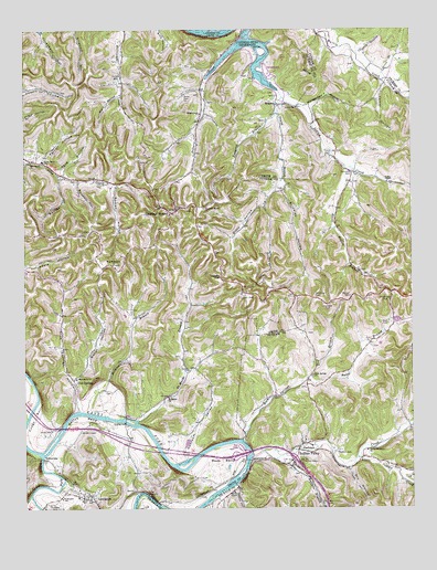
Buffalo Valley, TN USGS Topographic Map
Click on map above to begin viewing in our Map Viewer.

This topographic map contains these locations and features:
Feature Name Type Latitude Longitude GNIS ID View Map
Bates BranchStreamN36.1592°W85.7842°1276460View Map
Bates CemeteryCemeteryN36.2331°W85.8230°1276464View Map
Beller HollowValleyN36.1583°W85.8590°1305089View Map
Bettys BendBendN36.1484°W85.8575°1277196View Map
Blair HollowValleyN36.2334°W85.8439°1277648View Map
Bockman CemeteryCemeteryN36.2128°W85.7691°1277870View Map
Booker HollowValleyN36.2119°W85.8632°1305345View Map
Boyd CemeteryCemeteryN36.1734°W85.7580°1278108View Map
Brindley BranchStreamN36.2112°W85.7914°1647420View Map
Brindley HollowValleyN36.2082°W85.7917°1305422View Map
Buffalo BranchStreamN36.1384°W85.7944°1278900View Map
Buffalo ValleyPopulated PlaceN36.1414°W85.7867°1278920View Map
Buffalo Valley Post OfficePost OfficeN36.1366°W85.7894°1650872View Map
Buffalo Valley School (historical)SchoolN36.1412°W85.7825°1317769View Map
Burton CemeteryCemeteryN36.1803°W85.7703°1279131View Map
Burton School (historical)SchoolN36.1812°W85.8000°1317771View Map
Caney ForkPopulated PlaceN36.1376°W85.8014°1310878View Map
Chaffin BranchStreamN36.2442°W85.7680°1280191View Map
Chestnut MoundPopulated PlaceN36.2028°W85.8264°1280398View Map
Chestnut Mound ChurchChurchN36.2034°W85.8169°1280399View Map
Chestnut Mound Post OfficePost OfficeN36.2026°W85.8259°1651655View Map
Chestnut Mound School (historical)SchoolN36.1978°W85.8350°1321099View Map
Club SpringsPopulated PlaceN36.1578°W85.8583°1314862View Map
Club Springs HollowValleyN36.1508°W85.8575°1280787View Map
Club Springs School (historical)SchoolN36.1589°W85.8594°1321100View Map
Commissioner District 8CivilN36.2205°W85.8633°2464699View Map
Congo BottomBendN36.1495°W85.8717°1306071View Map
Cowan CemeteryCemeteryN36.2170°W85.7766°1281457View Map
Denny Seminary (historical)SchoolN36.1401°W85.7653°1317786View Map
Denny Seminary ChurchChurchN36.1401°W85.7647°1282348View Map
Dickens CemeteryCemeteryN36.2373°W85.8444°1282430View Map
Dillard Creek ChurchChurchN36.2284°W85.8183°1282474View Map
Ditty HollowValleyN36.2042°W85.7972°1282505View Map
Dry HollowValleyN36.1358°W85.7713°1283001View Map
EnigmaLocaleN36.2306°W85.7939°1283801View Map
Ensor HollowValleyN36.2138°W85.7702°1310898View Map
Ensor Hollow BranchStreamN36.2142°W85.7714°1283821View Map
Ferguson BranchStreamN36.1501°W85.8553°1284205View Map
Ferguson HollowValleyN36.1585°W85.8485°1647595View Map
Ferrell HollowValleyN36.2156°W85.8694°1284225View Map
Ford HollowValleyN36.2137°W85.8644°1284572View Map
Forks of the River Division (historical)CensusN36.2003°W85.8530°1648960View Map
Forks River Elementary SchoolSchoolN36.2162°W85.8689°1648332View Map
Granville Recreation AreaParkN36.2387°W85.7958°1321117View Map
Hale Seminary (historical)SchoolN36.1884°W85.8467°1321119View Map
Happy HollowValleyN36.1313°W85.8069°1313950View Map
Harris ChapelChurchN36.1292°W85.8080°1313951View Map
Huddleston CemeteryCemeteryN36.1803°W85.7580°1288604View Map
Indian CreekStreamN36.1381°W85.8025°1288961View Map
Interchange 268CrossingN36.1381°W85.7880°1310929View Map
Jack Apple ChurchChurchN36.2306°W85.7936°1289141View Map
Jared School (historical)SchoolN36.2048°W85.7972°1317803View Map
LancasterPopulated PlaceN36.1276°W85.8542°1290568View Map
Lancaster Baptist ChurchChurchN36.1284°W85.8550°1321125View Map
Lancaster Post OfficePost OfficeN36.1276°W85.8558°1651670View Map
Lancaster SchoolSchoolN36.1278°W85.8630°1290576View Map
Laurel LakeReservoirN36.2234°W85.8433°1302431View Map
Laurel Lake DamDamN36.2234°W85.8433°1302430View Map
Laycock BridgeBridgeN36.1481°W85.8428°1307250View Map
Little Indian CreekStreamN36.1378°W85.7686°1291544View Map
Little Indian CreekStreamN36.2470°W85.8042°1303486View Map
Macedonia ChurchChurchN36.1592°W85.8583°1307269View Map
Maddux CemeteryCemeteryN36.1395°W85.7750°1292477View Map
Maggart United Methodist ChurchChurchN36.2453°W85.8430°1321131View Map
McKinley CemeteryCemeteryN36.1812°W85.7814°1293368View Map
Medley HollowValleyN36.1344°W85.7532°1293532View Map
Moccasin Bluff School (historical)SchoolN36.1264°W85.8155°1322596View Map
Montgomery HollowValleyN36.2301°W85.7828°1294203View Map
Moss BendBendN36.1367°W85.8122°1294494View Map
New Macedonia ChurchChurchN36.1887°W85.8461°1295598View Map
New Salem ChurchChurchN36.2156°W85.8722°1295638View Map
Opossum ValleyValleyN36.1380°W85.8228°1296463View Map
Pekin (historical)Populated PlaceN36.1814°W85.7569°1644944View Map
Pricnard CemeteryCemeteryN36.1262°W85.8655°1298525View Map
Rock Springs BranchStreamN36.1431°W85.8047°1299796View Map
Rock Springs ChurchChurchN36.1598°W85.7825°1299799View Map
Rock Springs School (historical)SchoolN36.1601°W85.7830°1317828View Map
Russell HollowValleyN36.2108°W85.8575°1300337View Map
Sadler HollowValleyN36.2361°W85.7587°1300399View Map
Saint Mary School (historical)SchoolN36.1617°W85.8225°1321145View Map
Saint Marys BranchStreamN36.1478°W85.8392°1300476View Map
Saint Marys ChurchChurchN36.1542°W85.8286°1300481View Map
SebowishaPopulated PlaceN36.1381°W85.8689°1315886View Map
Sebowisha Post Office (historical)Post OfficeN36.1381°W85.8689°1926759View Map
Smith County Fire Department District 2BuildingN36.2157°W85.8722°2654626View Map
Smith County Fire Department District 6BuildingN36.1283°W85.8559°2654867View Map
Smith Fork CreekStreamN36.1389°W85.8697°1313776View Map
Spring Fork BranchStreamN36.2367°W85.7586°1271101View Map
Sullin HollowValleyN36.2037°W85.7974°1311007View Map
Sullins BranchStreamN36.2103°W85.7917°1311008View Map
Sumac HollowValleyN36.2097°W85.8461°1303927View Map
Tanyard BranchStreamN36.2284°W85.7939°1272103View Map
Timberlake HollowValleyN36.2157°W85.8744°1272652View Map
Trinity ChurchChurchN36.2295°W85.7872°1272892View Map
Trinity School (historical)SchoolN36.2295°W85.7866°1321156View Map
Vaden ChapelChurchN36.2103°W85.7580°1304281View Map
Vaden School (historical)SchoolN36.2101°W85.7572°1317849View Map
Young BranchStreamN36.2326°W85.7917°1275314View Map

Note: Coordinates in the location and feature list above are referenced to NAD83 datum.


Copyright (C) 2008-2024 Ryan Niemi / Sunset Dynamics ... All Rights Reserved