TopoQuest Logo
Do you find TopoQuest useful?
Help keep TopoQuest running and adding new maps/features by donating!
Bitcoin:  19c7KJd3qBynnjoSw5npx9KScwjBe4ifkT
Litecoin:  LXs6TkuXGGXo1vDsWCkWVdjQX94eUKd6ui
Home View Maps Find Maps Find Places Resources & Links


Brookston, Indiana Topographic Map

USGS Map Title: Brookston, IN
USGS Map MRC: 40086E7
DRG (GeoTIFF) Download: o40086e7.tif


Neighboring USGS Topographic Map Quads:


  Brookston NW, IN  
40086F8
 

  Monticello South, IN  
40086F7
 

  Yeoman, IN  
40086F6
 

  Brookston SW, IN  
40086E8
 

  Brookston, IN  
40086E7
 

  Delphi, IN  
40086E6
 

  Lafayette West, IN  
40086D8
 

  Lafayette East, IN  
40086D7
 

  Pyrmont, IN  
40086D6


Map MRC Location:

N41°
W87°
N41°
W86°
H8 H7 H6 H5 H4 H3 H2 H1
G8 G7 G6 G5 G4 G3 G2 G1
F8 F7 F6 F5 F4 F3 F2 F1
E8 E7 E6 E5 E4 E3 E2 E1
D8 D7 D6 D5 D4 D3 D2 D1
C8 C7 C6 C5 C4 C3 C2 C1
B8 B7 B6 B5 B4 B3 B2 B1
A8 A7 A6 A5 A4 A3 A2 A1
N40°
W87°
N40°
W86°

Brookston, IN USGS 1:24K Topographic Map Preview:
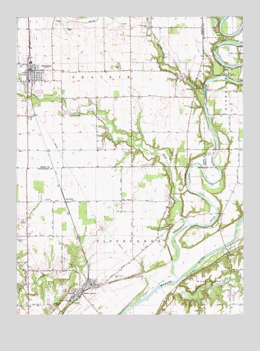
Brookston, IN USGS Topographic Map
Click on map above to begin viewing in our Map Viewer.

This topographic map contains these locations and features:
Feature Name Type Latitude Longitude GNIS ID View Map
AmericusPopulated PlaceN40.5259°W86.7581°430134View Map
Americus CemeteryCemeteryN40.5195°W86.7566°430135View Map
Ash GrovePopulated PlaceN40.5478°W86.8478°449614View Map
Bartlett Airport (historical)AirportN40.5945°W86.8347°449116View Map
Battle GroundPopulated PlaceN40.5084°W86.8417°430580View Map
Battle Ground CampgroundLocaleN40.5050°W86.8453°430581View Map
Battle Ground CemeteryCemeteryN40.5157°W86.8216°430582View Map
Battle Ground Elementary SchoolSchoolN40.5150°W86.8339°447590View Map
Battle Ground Junior High SchoolSchoolN40.5125°W86.8339°447589View Map
Battle Ground Police DepartmentBuildingN40.5106°W86.8406°2758349View Map
BrookstonPopulated PlaceN40.6028°W86.8672°431585View Map
Brookston Police DepartmentBuildingN40.6025°W86.8658°2758238View Map
Brookston Prairie Township Volunteer Fire DepartmentBuildingN40.6005°W86.8668°2626420View Map
Buck CreekStreamN40.5003°W86.8150°431725View Map
Camp TecumsehParkN40.6009°W86.7581°432067View Map
Chalmers - Brookston First ResponseBuildingN40.6025°W86.8659°2719426View Map
Frontier Elementary SchoolSchoolN40.5981°W86.8683°447511View Map
Frontier Middle SchoolSchoolN40.5981°W86.8683°447510View Map
Harrison CreekStreamN40.5034°W86.8136°435787View Map
Harvey CemeteryCemeteryN40.5476°W86.8589°435851View Map
Independent Order of Odd Fellows CemeteryCemeteryN40.6046°W86.8741°436688View Map
Indiana State Police Department District 14BuildingN40.5035°W86.8676°2758488View Map
Moots CreekStreamN40.5378°W86.7800°439416View Map
North Fork Burnett CreekStreamN40.5109°W86.8711°440248View Map
Pretty Prairie CemeteryCemeteryN40.5457°W86.7906°441583View Map
Prophet RockPillarN40.5045°W86.8517°441609View Map
Smelcer CemeteryCemeteryN40.5908°W86.8414°443656View Map
Spring CreekStreamN40.5923°W86.7711°443973View Map
Spring Creek CemeteryCemeteryN40.6207°W86.8023°443977View Map
SpringboroPopulated PlaceN40.5945°W86.7758°444002View Map
Tippecanoe Battlefield MemorialParkN40.5061°W86.8447°444775View Map
Tippecanoe RiverStreamN40.5150°W86.7856°452944View Map
Tippecanoe Township Volunteer Fire DepartmentBuildingN40.5105°W86.8387°2625747View Map
Town of Battle GroundCivilN40.5075°W86.8527°2396586View Map
Town of BrookstonCivilN40.6010°W86.8663°2396608View Map
Township of TippecanoeCivilN40.5269°W86.8518°453898View Map
Wallys Woods LakeReservoirN40.6219°W86.7652°447766View Map
Wallys Woods Lake DamDamN40.6200°W86.7650°447765View Map
Walters DitchCanalN40.5442°W86.8653°445450View Map

Note: Coordinates in the location and feature list above are referenced to NAD83 datum.


Copyright (C) 2008-2024 Ryan Niemi / Sunset Dynamics ... All Rights Reserved