TopoQuest Logo
Do you find TopoQuest useful?
Help keep TopoQuest running and adding new maps/features by donating!
Bitcoin:  19c7KJd3qBynnjoSw5npx9KScwjBe4ifkT
Litecoin:  LXs6TkuXGGXo1vDsWCkWVdjQX94eUKd6ui
Home View Maps Find Maps Find Places Resources & Links


Confluence, Pennsylvania Topographic Map

USGS Map Title: Confluence, PA
USGS Map MRC: 39079G3
DRG (GeoTIFF) Download: o39079g3.tif


Neighboring USGS Topographic Map Quads:


  Mill Run, PA  
39079H4
 

  Kingwood, PA  
39079H3
 

  Rockwood, PA  
39079H2
 

  Ohiopyle, PA  
39079G4
 

  Confluence, PA  
39079G3
 

  Markleton, PA  
39079G2
 

  Friendsville, MD  
39079F4
 

  Accident, MD  
39079F3
 

  Grantsville, MD  
39079F2


Map MRC Location:

N40°
W80°
N40°
W79°
H8 H7 H6 H5 H4 H3 H2 H1
G8 G7 G6 G5 G4 G3 G2 G1
F8 F7 F6 F5 F4 F3 F2 F1
E8 E7 E6 E5 E4 E3 E2 E1
D8 D7 D6 D5 D4 D3 D2 D1
C8 C7 C6 C5 C4 C3 C2 C1
B8 B7 B6 B5 B4 B3 B2 B1
A8 A7 A6 A5 A4 A3 A2 A1
N39°
W80°
N39°
W79°

Confluence, PA USGS 1:24K Topographic Map Preview:
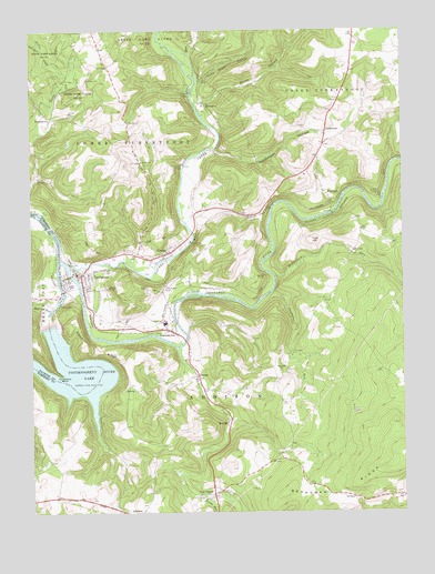
Confluence, PA USGS Topographic Map
Click on map above to begin viewing in our Map Viewer.

This topographic map contains these locations and features:
Feature Name Type Latitude Longitude GNIS ID View Map
Alex RunStreamN39.8701°W79.3706°1168139View Map
BeachlyPopulated PlaceN39.7740°W79.3078°1168836View Map
Becket RunStreamN39.7765°W79.3109°1890223View Map
Benford TunnelTunnelN39.8115°W79.2953°1169238View Map
Bethel ChurchChurchN39.8490°W79.3486°1205324View Map
Bethel Church (historical)ChurchN39.8545°W79.2731°1205322View Map
Boardman RidgeRidgeN39.7554°W79.2750°1169922View Map
Borough of ConfluenceCivilN39.8094°W79.3552°1215586View Map
Borough of UrsinaCivilN39.8153°W79.3325°1215600View Map
Brooks TunnelTunnelN39.8279°W79.2973°1170341View Map
Brushtown SchoolSchoolN39.8667°W79.3456°1205325View Map
Casselman RiverStreamN39.8151°W79.3648°1200066View Map
Coffin Rock ChurchChurchN39.7806°W79.3064°1205318View Map
Coke Oven HollowValleyN39.8617°W79.3175°1172141View Map
ConfluencePopulated PlaceN39.8129°W79.3567°1172325View Map
Confluence Borough Police DepartmentBuildingN39.8123°W79.3579°2780530View Map
Confluence Community Ambulance ServiceBuildingN39.8122°W79.3602°2719649View Map
Confluence Oakland Junction StationLocaleN39.8179°W79.3642°1212259View Map
Confluence Post OfficePost OfficeN39.8115°W79.3594°2779676View Map
Confluence Volunteer Fire Company Station 612BuildingN39.8122°W79.3602°2644798View Map
Crossroads CemeteryCemeteryN39.8078°W79.3295°1172762View Map
Cucumber RunStreamN39.8073°W79.2936°1172809View Map
DraketownPopulated PlaceN39.8529°W79.3673°1173455View Map
DumasPopulated PlaceN39.7856°W79.3192°1173591View Map
Dumas SchoolSchoolN39.7801°W79.3164°1205317View Map
Fairoaks ChurchChurchN39.8370°W79.3720°1174456View Map
Fort HillPopulated PlaceN39.8304°W79.2725°1175007View Map
Fort HillSummitN39.8206°W79.2803°1175008View Map
Fort Hill ChurchChurchN39.8176°W79.2661°1175011View Map
Fort Hill Post OfficePost OfficeN39.8321°W79.2744°2779693View Map
Fort Hill SchoolSchoolN39.8184°W79.2664°1205320View Map
Glade RunStreamN39.8106°W79.2517°1175656View Map
HarnedsvillePopulated PlaceN39.7976°W79.3278°1176563View Map
Hen RunStreamN39.8031°W79.3684°1176822View Map
Horseshoe BendBendN39.7865°W79.3670°1177458View Map
HumbertPopulated PlaceN39.8562°W79.3153°1203855View Map
Jersey ChurchChurchN39.8412°W79.3373°1178057View Map
Klondike RidgeRidgeN39.7926°W79.3573°1178594View Map
Kregar School (historical)SchoolN39.8459°W79.3464°1205323View Map
Laurel Hill CreekStreamN39.8148°W79.3617°1198156View Map
Laurel RunStreamN39.7540°W79.3178°1178997View Map
Licking RunStreamN39.8148°W79.3425°1212262View Map
Lincoln Siding StationLocaleN39.8179°W79.3642°1212261View Map
ListonburgPopulated PlaceN39.7548°W79.3142°1179452View Map
Little Glade RunStreamN39.8601°W79.3623°1192804View Map
Lost RunStreamN39.8287°W79.2573°1202111View Map
May RunStreamN39.8692°W79.3209°1180571View Map
McClintock RunStreamN39.8115°W79.2928°1180631View Map
PaddytownPopulated PlaceN39.8487°W79.2750°1204347View Map
Paddytown HollowValleyN39.8442°W79.3127°1183184View Map
Saint Pauls ChurchChurchN39.7534°W79.2509°1186567View Map
Shoofly TunnelTunnelN39.8326°W79.2573°1187581View Map
Silbaugh SchoolSchoolN39.7901°W79.2848°1205319View Map
Sillbaugh ChurchChurchN39.7867°W79.2909°1187664View Map
Smith HollowValleyN39.8565°W79.3166°1187879View Map
State Game Lands Number 271ParkN39.7751°W79.2664°1208408View Map
Township of AddisonCivilN39.7737°W79.2867°1217042View Map
Township of Lower TurkeyfootCivilN39.8688°W79.3541°1217054View Map
Turkeyfoot Valley SchoolSchoolN39.7995°W79.3298°1189955View Map
UrsinaPopulated PlaceN39.8176°W79.3278°1190271View Map
Ursina Junction StationLocaleN39.8117°W79.3575°1212260View Map
Whites CreekStreamN39.7929°W79.3256°1191335View Map
Youghiogheny DamDamN39.7984°W79.3681°1194359View Map
Youghiogheny River LakeReservoirN39.7850°W79.3690°1193703View Map
Younkin CemeteryCemeteryN39.8501°W79.2811°1191927View Map
Younkin SchoolSchoolN39.8734°W79.2648°1205321View Map

Note: Coordinates in the location and feature list above are referenced to NAD83 datum.


Copyright (C) 2008-2024 Ryan Niemi / Sunset Dynamics ... All Rights Reserved