TopoQuest Logo
Do you find TopoQuest useful?
Help keep TopoQuest running and adding new maps/features by donating!
Bitcoin:  19c7KJd3qBynnjoSw5npx9KScwjBe4ifkT
Litecoin:  LXs6TkuXGGXo1vDsWCkWVdjQX94eUKd6ui
Home View Maps Find Maps Find Places Resources & Links


Hazlehurst South, Georgia Topographic Map

USGS Map Title: Hazlehurst South, GA
USGS Map MRC: 31082G5
DRG (GeoTIFF) Download: o31082g5.tif


Neighboring USGS Topographic Map Quads:


  Lumber City, GA  
31082H6
 

  Hazlehurst North, GA  
31082H5
 

  Grays Landing, GA  
31082H4
 

  Roper, GA  
31082G6
 

  Hazlehurst South, GA  
31082G5
 

  Pine Grove, GA  
31082G4
 

  Denton, GA  
31082F6
 

  Nicholls NE, GA  
31082F5
 

  Alma NW, GA  
31082F4


Map MRC Location:

N32°
W83°
N32°
W82°
H8 H7 H6 H5 H4 H3 H2 H1
G8 G7 G6 G5 G4 G3 G2 G1
F8 F7 F6 F5 F4 F3 F2 F1
E8 E7 E6 E5 E4 E3 E2 E1
D8 D7 D6 D5 D4 D3 D2 D1
C8 C7 C6 C5 C4 C3 C2 C1
B8 B7 B6 B5 B4 B3 B2 B1
A8 A7 A6 A5 A4 A3 A2 A1
N31°
W83°
N31°
W82°

Hazlehurst South, GA USGS 1:24K Topographic Map Preview:
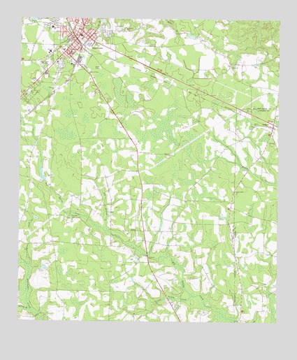
Hazlehurst South, GA USGS Topographic Map
Click on map above to begin viewing in our Map Viewer.

This topographic map contains these locations and features:
Feature Name Type Latitude Longitude GNIS ID View Map
Bazemore CemeteryCemeteryN31.8710°W82.5740°310899View Map
Bethany ChurchChurchN31.8469°W82.6090°311133View Map
Big BranchStreamN31.7905°W82.5829°354708View Map
Burket CreekStreamN31.7724°W82.6201°312047View Map
City of GrahamCivilN31.8292°W82.5030°2403721View Map
City of HazlehurstCivilN31.8651°W82.5994°2404670View Map
Ebenezer CemeteryCemeteryN31.7927°W82.5996°313811View Map
Ebenezer Church (historical)ChurchN31.7927°W82.5999°335096View Map
First Baptist ChurchChurchN31.8685°W82.5962°335101View Map
Good Shepherd ChurchChurchN31.8602°W82.5751°335103View Map
GrahamPopulated PlaceN31.8316°W82.5024°331846View Map
Graham Baptist ChurchChurchN31.8349°W82.5015°349154View Map
Graham Fire DepartmentBuildingN31.8310°W82.5001°2603693View Map
Graham Police DepartmentBuildingN31.8309°W82.5007°2733553View Map
Graham United Methodist ChurchChurchN31.8310°W82.5024°349156View Map
HazlehurstPopulated PlaceN31.8696°W82.5943°315266View Map
Hazlehurst City HallBuildingN31.8671°W82.5993°335108View Map
Hazlehurst DivisionCivilN31.8483°W82.5677°1936310View Map
Hazlehurst Fire Department Station 1BuildingN31.8638°W82.6059°2603545View Map
Hazlehurst Fire Department Station 2BuildingN31.8658°W82.5891°2604878View Map
Hazlehurst Police DepartmentBuildingN31.8673°W82.5994°2733666View Map
Hazlehurst Post OfficePost OfficeN31.8657°W82.5990°352083View Map
Jeff Davis County CourthouseBuildingN31.8627°W82.6007°335112View Map
Jeff Davis County Detention CenterBuildingN31.8675°W82.5994°2735705View Map
Jeff Davis County Fire Department Station 4 SatillaBuildingN31.7857°W82.5644°2604486View Map
Jeff Davis County Sheriff's OfficeBuildingN31.8621°W82.5998°2733883View Map
Jeff Davis High SchoolSchoolN31.8613°W82.6107°335113View Map
Jeff Davis HospitalHospitalN31.8571°W82.6070°335114View Map
Jeff Davis Junior High SchoolSchoolN31.8635°W82.6101°335115View Map
Jeff Davis SchoolSchoolN31.8713°W82.6093°316060View Map
Johnsonville (historical)Populated PlaceN31.8360°W82.5179°349168View Map
Little Satilla CreekStreamN31.7596°W82.5424°317190View Map
Maedonia ChurchChurchN31.8249°W82.5018°317598View Map
Maysie (historical)Populated PlaceN31.8657°W82.5379°335122View Map
Mims Mill (historical)LocaleN31.7516°W82.6193°335126View Map
Morgan Chapel Baptist ChurchChurchN31.8038°W82.5210°318465View Map
Morgan Chapel Missionary Baptist ChurchChurchN31.8245°W82.5046°2502701View Map
Morgans Chapel School (historical)SchoolN31.8038°W82.5207°349182View Map
Mount Zion ChurchChurchN31.8313°W82.5115°318958View Map
Mount Zion ChurchChurchN31.8560°W82.5229°318960View Map
Old Field BranchStreamN31.7541°W82.6187°319976View Map
Palmetto School (historical)SchoolN31.8260°W82.5712°335132View Map
Peoples ChurchChurchN31.8599°W82.5746°335134View Map
Quinn (historical)Populated PlaceN31.7919°W82.5518°335136View Map
Rocky Branch ChurchChurchN31.8691°W82.5482°321797View Map
SatillaPopulated PlaceN31.7874°W82.5679°332985View Map
Satilla Census Designated PlaceCensusN31.7921°W82.5640°2587046View Map
Satilla ChurchChurchN31.7863°W82.5721°335137View Map
Thompsons Chapel (historical)ChurchN31.8624°W82.5318°335142View Map
Union School (historical)SchoolN31.8021°W82.6199°335145View Map
WVOH-AM (Hazelhurst)TowerN31.8544°W82.5665°352463View Map
WVOH-FM (Hazlehurst)TowerN31.8544°W82.5665°352706View Map
Zoar United Methodist ChurchChurchN31.7505°W82.5112°349224View Map

Note: Coordinates in the location and feature list above are referenced to NAD83 datum.


Copyright (C) 2008-2024 Ryan Niemi / Sunset Dynamics ... All Rights Reserved