TopoQuest Logo
Do you find TopoQuest useful?
Help keep TopoQuest running and adding new maps/features by donating!
Bitcoin:  19c7KJd3qBynnjoSw5npx9KScwjBe4ifkT
Litecoin:  LXs6TkuXGGXo1vDsWCkWVdjQX94eUKd6ui
Home View Maps Find Maps Find Places Resources & Links


Wilbert, Minnesota Topographic Map

USGS Map Title: Wilbert, MN
USGS Map MRC: 43094E5
DRG (GeoTIFF) Download: o43094e5.tif


Neighboring USGS Topographic Map Quads:


  Sherburn, MN  
43094F6
 

  Welcome, MN  
43094F5
 

  Fairmont, MN  
43094F4
 

  Ceylon, MN  
43094E6
 

  Wilbert, MN  
43094E5
 

  Wilmert Lake, MN  
43094E4
 

  Gruver, IA  
43094D6
 

  Dolliver, IA  
43094D5
 

  Armstrong, IA  
43094D4


Map MRC Location:

N44°
W95°
N44°
W94°
H8 H7 H6 H5 H4 H3 H2 H1
G8 G7 G6 G5 G4 G3 G2 G1
F8 F7 F6 F5 F4 F3 F2 F1
E8 E7 E6 E5 E4 E3 E2 E1
D8 D7 D6 D5 D4 D3 D2 D1
C8 C7 C6 C5 C4 C3 C2 C1
B8 B7 B6 B5 B4 B3 B2 B1
A8 A7 A6 A5 A4 A3 A2 A1
N43°
W95°
N43°
W94°

Wilbert, MN USGS 1:24K Topographic Map Preview:
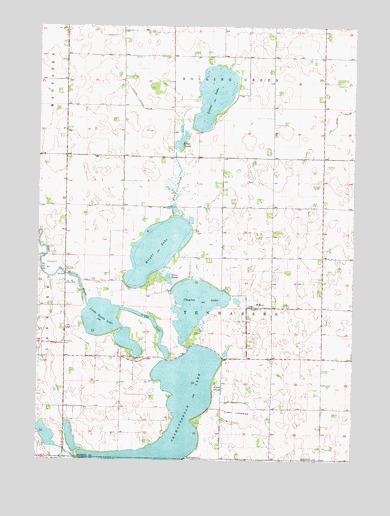
Wilbert, MN USGS Topographic Map
Click on map above to begin viewing in our Map Viewer.

This topographic map contains these locations and features:
Feature Name Type Latitude Longitude GNIS ID View Map
Bright LakeLakeN43.5606°W94.5781°640482View Map
Ceylon WaysideParkN43.5338°W94.6136°2049548View Map
Clayton LakeLakeN43.5450°W94.5629°641265View Map
Clear LakebedFlatN43.5138°W94.5461°641307View Map
County Ditch Number TwentyeightCanalN43.6011°W94.5014°641905View Map
Follett SloughGutN43.5208°W94.5533°643779View Map
Half Moon CemeteryCemeteryN43.5888°W94.5516°2049528View Map
Judicial Ditch Number ThirtysixCanalN43.6008°W94.5805°645909View Map
Kings SloughLakeN43.5913°W94.5694°646168View Map
Little Tuttle LakeLakeN43.5392°W94.5973°646955View Map
Martin County Waterfowl Production AreaParkN43.6111°W94.5667°2765395View Map
Mud SloughLakeN43.5802°W94.5708°648369View Map
Okamanpeedan LakeLakeN43.5013°W94.5753°464429View Map
Perry SloughGutN43.5525°W94.5739°649309View Map
Pierce LakeLakeN43.6053°W94.5559°649391View Map
Rosenberg AirportAirportN43.5216°W94.5783°660099View Map
Saint Paul's Lutheran CemeteryCemeteryN43.5611°W94.5397°2049527View Map
Saint Paul's Lutheran ChurchChurchN43.5441°W94.5397°2049519View Map
Saint Paul's Lutheran SchoolSchoolN43.5441°W94.5403°2049520View Map
Teitje Farm CemeteryCemeteryN43.5326°W94.5417°2049526View Map
Tenhassen CemeteryCemeteryN43.5294°W94.5880°653080View Map
The InletChannelN43.5402°W94.5794°653110View Map
Township of TenhassenCivilN43.5439°W94.5535°665772View Map
WilbertPopulated PlaceN43.5438°W94.5394°654129View Map
Wilbert Post Office (historical)Post OfficeN43.5438°W94.5394°2049401View Map

Note: Coordinates in the location and feature list above are referenced to NAD83 datum.


Copyright (C) 2008-2024 Ryan Niemi / Sunset Dynamics ... All Rights Reserved