TopoQuest Logo
Do you find TopoQuest useful?
Help keep TopoQuest running and adding new maps/features by donating!
Bitcoin:  19c7KJd3qBynnjoSw5npx9KScwjBe4ifkT
Litecoin:  LXs6TkuXGGXo1vDsWCkWVdjQX94eUKd6ui
Home View Maps Find Maps Find Places Resources & Links


Cardiff, Tennessee Topographic Map

USGS Map Title: Cardiff, TN
USGS Map MRC: 35084H6
DRG (GeoTIFF) Download: o35084h6.tif


Neighboring USGS Topographic Map Quads:


  Hebbertsburg, TN  
36084A7
 

  Lancing, TN  
36084A6
 

  Camp Austin, TN  
36084A5
 

  Ozone, TN  
35084H7
 

  Cardiff, TN  
35084H6
 

  Harriman, TN  
35084H5
 

  Roddy, TN  
35084G7
 

  Rockwood, TN  
35084G6
 

  Bacon Gap, TN  
35084G5


Map MRC Location:

N36°
W85°
N36°
W84°
H8 H7 H6 H5 H4 H3 H2 H1
G8 G7 G6 G5 G4 G3 G2 G1
F8 F7 F6 F5 F4 F3 F2 F1
E8 E7 E6 E5 E4 E3 E2 E1
D8 D7 D6 D5 D4 D3 D2 D1
C8 C7 C6 C5 C4 C3 C2 C1
B8 B7 B6 B5 B4 B3 B2 B1
A8 A7 A6 A5 A4 A3 A2 A1
N35°
W85°
N35°
W84°

Cardiff, TN USGS 1:24K Topographic Map Preview:
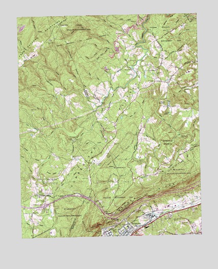
Cardiff, TN USGS Topographic Map
Click on map above to begin viewing in our Map Viewer.

This topographic map contains these locations and features:
Feature Name Type Latitude Longitude GNIS ID View Map
Ault CemeteryCemeteryN35.8756°W84.6269°1275977View Map
Baird CemeteryCemeteryN35.9053°W84.7247°1276124View Map
Becky BranchStreamN35.9809°W84.6852°1276748View Map
Birds BranchStreamN35.8990°W84.7274°1305254View Map
Black HollowValleyN35.8891°W84.6546°1277576View Map
Bladshaw BranchStreamN35.9592°W84.6861°1277630View Map
Board Camp BranchStreamN35.9315°W84.6385°1277843View Map
Browns GapGapN35.8845°W84.6880°1278627View Map
Brushy CreekStreamN35.9459°W84.6980°1278699View Map
Burning Springs WellWellN35.9204°W84.6902°1279080View Map
Camp HowardLocaleN35.9440°W84.6449°1279397View Map
Caney BranchStreamN35.9273°W84.6524°1279555View Map
CardiffPopulated PlaceN35.8906°W84.6310°1314793View Map
Cardiff CemeteryCemeteryN35.8901°W84.6319°1326165View Map
Cardiff MineMineN35.8995°W84.6305°1316372View Map
Chucky CreekStreamN35.9451°W84.6999°1280540View Map
Clure BranchStreamN35.9159°W84.6622°1280789View Map
Coalbank BranchStreamN35.9806°W84.6933°1280802View Map
Coalbank HollowValleyN35.8806°W84.6945°1280804View Map
Cumberland PlateauPlainN35.9442°W84.6816°1303434View Map
DeerwoodPopulated PlaceN35.9356°W84.7055°1302852View Map
Dry HillPopulated PlaceN35.9101°W84.6547°1314976View Map
Dry Hill CemeteryCemeteryN35.9117°W84.6538°1326170View Map
Dry Hill Church (historical)ChurchN35.9123°W84.6538°1316386View Map
Dry Hill School (historical)SchoolN35.9112°W84.6538°1316387View Map
Eads CemeteryCemeteryN35.9687°W84.6366°1283278View Map
Eblen GapGapN35.8976°W84.6616°1283489View Map
Evans BranchStreamN35.9267°W84.7091°1283894View Map
Fagan Mill CreekStreamN35.9837°W84.6661°1283961View Map
Farmer CemeteryCemeteryN35.9076°W84.7027°1284133View Map
Flat Rock FordCrossingN35.9692°W84.6708°1315061View Map
Galbreth RidgeRidgeN35.9973°W84.6447°1285083View Map
Golliher CemeteryCemeteryN35.9003°W84.7380°1285596View Map
Golliher CreekStreamN35.9709°W84.6711°1285597View Map
Grammer SpringSpringN35.9949°W84.7208°1285812View Map
Graves RidgeRidgeN35.9106°W84.7283°1285966View Map
Hembree CemeteryCemeteryN35.8951°W84.6269°1287359View Map
Henson CreekStreamN35.9359°W84.7191°1287479View Map
Hollow BranchStreamN35.8809°W84.6947°1310444View Map
Interchange 338CrossingN35.8931°W84.7338°1302884View Map
Kittrell RidgeRidgeN35.9662°W84.6336°1290336View Map
Laurel BranchStreamN35.8806°W84.7288°1290711View Map
Lick BranchStreamN35.9365°W84.7252°1291193View Map
Little Laurel CreekStreamN35.9937°W84.6630°1291555View Map
Lively CreekStreamN35.9562°W84.6880°1291731View Map
McGuffey BranchStreamN35.9584°W84.6822°1293330View Map
Moulders School (historical)SchoolN35.8895°W84.7333°1302909View Map
Mount PisgahLocaleN35.9290°W84.7127°1318261View Map
Mount Pisgah CemeteryCemeteryN35.9298°W84.7127°1318260View Map
Mount Pisgah ChurchChurchN35.9295°W84.7133°1294743View Map
Mount Pisgah School (historical)SchoolN35.9290°W84.7133°1302908View Map
Mount Teman ChurchChurchN35.9092°W84.6649°1294809View Map
Mount Vernal ChurchChurchN35.8992°W84.7311°1294818View Map
Mount VernonPopulated PlaceN35.8987°W84.7319°1646859View Map
North Rockwood ChurchChurchN35.8890°W84.6711°1295945View Map
Patel BranchStreamN35.9081°W84.7358°1296911View Map
Patton MineMineN35.8862°W84.6708°1316435View Map
Pine OrchardPopulated PlaceN35.9681°W84.6538°1315714View Map
Pine Orchard Baptist ChurchChurchN35.9687°W84.6533°1643772View Map
Pine Orchard CemeteryCemeteryN35.9692°W84.6530°1646652View Map
Pine Orchard CemeteryCemeteryN35.9703°W84.6555°1646653View Map
Pine Orchard School (historical)SchoolN35.9690°W84.6538°1324922View Map
Powder Mill CreekStreamN35.9098°W84.7438°1298380View Map
Powell CemeteryCemeteryN35.9056°W84.6860°1298406View Map
Price CemeteryCemeteryN35.9015°W84.7333°1298500View Map
Pyott BranchGutN35.8870°W84.6641°1298728View Map
Pyott CemeteryCemeteryN35.8851°W84.6619°1298730View Map
Roane County Industrial ParkLocaleN35.8862°W84.6602°1316449View Map
Roane Memorial GardensParkN35.8831°W84.6449°1299559View Map
Roane State Community CollegeSchoolN35.8770°W84.6319°1316452View Map
Rock Bottom BranchStreamN35.9342°W84.6277°1299726View Map
Rockwood MineMineN35.8931°W84.6755°1316457View Map
Rockwood Municipal AirportAirportN35.9181°W84.6975°1301377View Map
Rocky CreekStreamN35.9776°W84.6611°1299880View Map
Round MountainSummitN35.9492°W84.6480°1300165View Map
Sandstone BranchStreamN35.9176°W84.6708°1300726View Map
Shahan HollowValleyN35.8878°W84.6858°1301201View Map
Skidmore CemeteryCemeteryN35.9737°W84.6730°1270429View Map
Smith MountainSummitN35.9840°W84.7366°1303685View Map
Snow CemeteryCemeteryN35.9326°W84.6430°1270779View Map
Sulphur Spring BranchStreamN35.9809°W84.6874°1271804View Map
Taylor CreekStreamN35.9512°W84.6927°1272227View Map
Tedder CemeteryCemeteryN35.8795°W84.6652°1272268View Map
Thornburg BranchStreamN35.9304°W84.6299°1272565View Map
Victory ChurchChurchN35.8837°W84.6730°1273453View Map
Warner MineMineN35.8967°W84.6444°1316470View Map
Watson CemeteryCemeteryN35.9473°W84.7419°1273924View Map
Westel Community CenterBuildingN35.8954°W84.7333°1274244View Map
Whiteoak ForkStreamN35.9195°W84.6724°1274436View Map
Wolfpen BranchStreamN35.9181°W84.7336°1274995View Map

Note: Coordinates in the location and feature list above are referenced to NAD83 datum.


Copyright (C) 2008-2024 Ryan Niemi / Sunset Dynamics ... All Rights Reserved