TopoQuest Logo
Do you find TopoQuest useful?
Help keep TopoQuest running and adding new maps/features by donating!
Bitcoin:  19c7KJd3qBynnjoSw5npx9KScwjBe4ifkT
Litecoin:  LXs6TkuXGGXo1vDsWCkWVdjQX94eUKd6ui
Home View Maps Find Maps Find Places Resources & Links


Bacon Gap, Tennessee Topographic Map

USGS Map Title: Bacon Gap, TN
USGS Map MRC: 35084G5
DRG (GeoTIFF) Download: o35084g5.tif


Neighboring USGS Topographic Map Quads:


  Cardiff, TN  
35084H6
 

  Harriman, TN  
35084H5
 

  Elverton, TN  
35084H4
 

  Rockwood, TN  
35084G6
 

  Bacon Gap, TN  
35084G5
 

  Cave Creek, TN  
35084G4
 

  Ten Mile, TN  
35084F6
 

  Pattie Gap, TN  
35084F5
 

  Philadelphia, TN  
35084F4


Map MRC Location:

N36°
W85°
N36°
W84°
H8 H7 H6 H5 H4 H3 H2 H1
G8 G7 G6 G5 G4 G3 G2 G1
F8 F7 F6 F5 F4 F3 F2 F1
E8 E7 E6 E5 E4 E3 E2 E1
D8 D7 D6 D5 D4 D3 D2 D1
C8 C7 C6 C5 C4 C3 C2 C1
B8 B7 B6 B5 B4 B3 B2 B1
A8 A7 A6 A5 A4 A3 A2 A1
N35°
W85°
N35°
W84°

Bacon Gap, TN USGS 1:24K Topographic Map Preview:
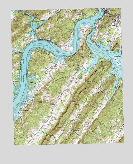
Bacon Gap, TN USGS Topographic Map
Click on map above to begin viewing in our Map Viewer.

This topographic map contains these locations and features:
Feature Name Type Latitude Longitude GNIS ID View Map
Ambrose SpringSpringN35.8165°W84.5717°1275656View Map
Anglers CovePopulated PlaceN35.8204°W84.5319°1314585View Map
Bacon CemeteryCemeteryN35.7926°W84.5597°1276062View Map
Bacon GapGapN35.7859°W84.5547°1276069View Map
Bacon RidgeRidgeN35.7770°W84.5677°1276070View Map
Barnard CemeteryCemeteryN35.7842°W84.5808°1276331View Map
Barnard Division (historical)CensusN35.7542°W84.5730°1648921View Map
Barnard NarrowsGapN35.7584°W84.5849°1304961View Map
Barnard Narrows BranchStreamN35.7637°W84.5930°1276336View Map
Barnard SpringSpringN35.7874°W84.5772°1276337View Map
BarnardsvillePopulated PlaceN35.7612°W84.5991°1310394View Map
Bat HollowValleyN35.7741°W84.5545°1276446View Map
Bethel CemeteryCemeteryN35.7973°W84.5710°1326162View Map
Bethel CemeteryCemeteryN35.8690°W84.5172°1277110View Map
Bethel ChurchChurchN35.7965°W84.5716°1277124View Map
BEthel United Presbyterian ChurchChurchN35.8709°W84.5180°1316139View Map
Biss CemeteryCemeteryN35.8495°W84.5305°1277529View Map
Bowers CemeteryCemeteryN35.8506°W84.6066°1278050View Map
Bowman BranchStreamN35.8576°W84.5966°1278067View Map
Bowman CemeteryCemeteryN35.8512°W84.6069°1278073View Map
Brown CemeteryCemeteryN35.7812°W84.6163°1278541View Map
Brown EllisPopulated PlaceN35.8717°W84.5466°1278575View Map
Bullet BranchStreamN35.8365°W84.6122°1278965View Map
Butler CemeteryCemeteryN35.8012°W84.6024°1279177View Map
Caney CreekStreamN35.8473°W84.5949°1279564View Map
Caney Creek CampgroundLocaleN35.8737°W84.6124°1316369View Map
Caney Creek DockLocaleN35.8745°W84.6110°1316370View Map
Caney Creek Island (historical)IslandN35.8429°W84.5916°1644093View Map
Caney Ford ChurchChurchN35.8645°W84.5869°1305672View Map
Caney Fork Church (historical)ChurchN35.8542°W84.5974°1316371View Map
Caney ShoalsBarN35.8417°W84.6033°1644094View Map
Center CemeteryCemeteryN35.8648°W84.5491°1280121View Map
Chamberlain BranchStreamN35.8154°W84.5119°1305841View Map
Chamberlin School (historical)SchoolN35.7992°W84.5283°1316377View Map
Chapman BranchStreamN35.8315°W84.5708°1305857View Map
Chapman GrovePopulated PlaceN35.8217°W84.5805°1314820View Map
Chapman Grove ChurchChurchN35.8215°W84.5808°1316378View Map
Cherokee HillsPopulated PlaceN35.8581°W84.5047°1305874View Map
Cherokee Middle SchoolSchoolN35.8631°W84.5033°1648274View Map
Christopher CemeteryCemeteryN35.7628°W84.5663°1280535View Map
Circle MPopulated PlaceN35.8473°W84.5610°1310407View Map
Claude Reed DamDamN35.7751°W84.6133°1302128View Map
Claude Reed LakeReservoirN35.7751°W84.6133°1302127View Map
Clinch RiverStreamN35.8634°W84.5319°1307258View Map
Commissioner District 7CivilN35.7560°W84.5705°2464637View Map
CrestwoodPopulated PlaceN35.8381°W84.5005°1281608View Map
Delaney CemeteryCemeteryN35.8423°W84.6122°1282311View Map
Durham CemeteryCemeteryN35.7967°W84.5347°1283227View Map
Ebben Island (historical)IslandN35.8329°W84.5210°1310412View Map
Ellis Ferry (historical)CrossingN35.8154°W84.6116°1316392View Map
Ellis Ford (historical)CrossingN35.8151°W84.6116°1316393View Map
FairviewPopulated PlaceN35.7962°W84.5694°1315039View Map
Fairview AcresPopulated PlaceN35.7917°W84.5749°1310417View Map
Fairview SchoolSchoolN35.7967°W84.5699°1316396View Map
Fort Southwest Point (historical)LocaleN35.8606°W84.5291°1316398View Map
Green AcresPopulated PlaceN35.8440°W84.5113°1286059View Map
Greenbrier BranchStreamN35.7645°W84.5435°1286145View Map
Hackler GapGapN35.8070°W84.5352°1286478View Map
Hagler CemeteryCemeteryN35.7881°W84.6110°1286496View Map
Holiday HillsPopulated PlaceN35.7831°W84.6135°1315246View Map
Hood BranchStreamN35.7931°W84.6041°1288219View Map
Hood CemeteryCemeteryN35.8281°W84.5655°1288225View Map
Hood Landing (historical)LocaleN35.8317°W84.5652°1316407View Map
Hood Landing Ferry (historical)CrossingN35.8329°W84.5652°1644107View Map
Idle OaksPopulated PlaceN35.8140°W84.5972°1310427View Map
Iron Divide (historical)Populated PlaceN35.8154°W84.5227°1310434View Map
Isham CemeteryCemeteryN35.7876°W84.5785°1289077View Map
Jackson BranchStreamN35.7762°W84.6183°1289184View Map
Jackson CemeteryCemeteryN35.7787°W84.6224°1289200View Map
James Ferry (historical)CrossingN35.8423°W84.5333°1316410View Map
Kelsay CemeteryCemeteryN35.7640°W84.5530°1290050View Map
Kingston Church of ChristChurchN35.8737°W84.5155°1316149View Map
Kingston Elementary SchoolSchoolN35.8745°W84.5185°1316413View Map
Kingston Fire DepartmentBuildingN35.8727°W84.5170°2654302View Map
Kingston First Baptist ChurchChurchN35.8729°W84.5160°1644116View Map
Kingston United Methodist ChurchChurchN35.8717°W84.5185°1316150View Map
Kingston Waterfront ParkParkN35.8729°W84.5213°1316415View Map
Lacy CemeteryCemeteryN35.7762°W84.5549°1290446View Map
Lake ShadowPopulated PlaceN35.8204°W84.5860°1310442View Map
LakeharborPopulated PlaceN35.8087°W84.6027°1315342View Map
LakeviewPopulated PlaceN35.8551°W84.5466°1290518View Map
Laurel BluffPopulated PlaceN35.7979°W84.5227°1315357View Map
Laurel Bluff Baptist ChurchChurchN35.7979°W84.5222°1644118View Map
Laurel Bluff BranchStreamN35.7901°W84.5166°1290685View Map
Laurel Bluff CemeteryCemeteryN35.7981°W84.5391°1326184View Map
Lewis CemeteryCemeteryN35.7728°W84.5780°1291071View Map
Long IslandIslandN35.8234°W84.5033°1291980View Map
Long Island Wildlife Management AreaParkN35.8237°W84.5033°1291983View Map
Margrave ValleyValleyN35.8628°W84.5911°1292680View Map
Marney BluffCliffN35.8331°W84.5530°1292717View Map
Mars Hill ChurchChurchN35.8637°W84.5052°1292741View Map
Marsh SpringSpringN35.8243°W84.5635°1292753View Map
Martin BranchStreamN35.8429°W84.5252°1292791View Map
Martin CemeteryCemeteryN35.8659°W84.5888°1292807View Map
Midtown DockLocaleN35.8684°W84.5419°1293721View Map
MidwayPopulated PlaceN35.7762°W84.5516°1315499View Map
Midway ChurchChurchN35.7687°W84.5574°1293737View Map
Midway Elementary SchoolSchoolN35.7762°W84.5524°1316419View Map
Midway High SchoolSchoolN35.7770°W84.5524°1316420View Map
MontcrestPopulated PlaceN35.8501°W84.5630°1310447View Map
Morrison Hill ChurchChurchN35.8684°W84.5024°1294452View Map
Oak Grove ChurchChurchN35.8726°W84.5785°1296097View Map
Parker CemeteryCemeteryN35.7548°W84.5566°1296809View Map
Picket CemeteryCemeteryN35.8128°W84.6072°1297394View Map
Picketts Landing (historical)LocaleN35.8154°W84.6091°1316438View Map
Pisgah RidgeRidgeN35.8395°W84.5072°1297725View Map
Ponder ChurchChurchN35.7620°W84.5569°1316441View Map
PondersPopulated PlaceN35.7620°W84.5558°1315752View Map
Ponders BranchStreamN35.7567°W84.5497°1298121View Map
Ponders GapGapN35.7620°W84.5560°1298122View Map
Richardsons Ferry (historical)CrossingN35.8726°W84.5230°1644131View Map
Riley CemeteryCemeteryN35.8192°W84.5477°1299450View Map
Riley CreekStreamN35.8320°W84.5297°1299458View Map
Riley Creek AirportAirportN35.8243°W84.5382°1301370View Map
Riley Creek Recreational AreaParkN35.8279°W84.5258°1316447View Map
River KnobsSummitN35.8545°W84.5705°1299496View Map
Roane CountyCivilN35.8479°W84.5232°1639785View Map
Roane County ParkParkN35.8645°W84.5985°1299557View Map
Roane County Sheriff's OfficeBuildingN35.8726°W84.5140°2765819View Map
Rose CemeteryCemeteryN35.7695°W84.5397°1300067View Map
Rose SpringSpringN35.8184°W84.5495°1300089View Map
Round Island (historical)IslandN35.8167°W84.5041°1310461View Map
Scott SpringSpringN35.7911°W84.5996°1300961View Map
Sequoyah ShoresPopulated PlaceN35.8473°W84.5288°1310463View Map
Shanty BranchStreamN35.8595°W84.5958°1301241View Map
Shields BarBarN35.7967°W84.6180°1310465View Map
Shields CemeteryCemeteryN35.7951°W84.6002°1270059View Map
Shields Dam (historical)DamN35.7876°W84.6222°1644136View Map
Shields SpringSpringN35.7963°W84.5999°1270064View Map
Shiloh CemeteryCemeteryN35.7590°W84.5972°1270081View Map
Shiloh ChurchChurchN35.7709°W84.5894°1303582View Map
Shiloh Church (historical)ChurchN35.7609°W84.6033°1316459View Map
Slave CemeteryCemeteryN35.8284°W84.5252°1270495View Map
Slave CemeteryCemeteryN35.8581°W84.5352°1270496View Map
Smalley RidgeRidgeN35.7992°W84.5449°1303665View Map
South Roane County Volunteer Fire Department Station 1BuildingN35.8113°W84.5495°2654911View Map
South West PointCapeN35.8620°W84.5305°1310468View Map
Southwest Point Golf CourseLocaleN35.8565°W84.5416°1270925View Map
Southwest Point ParkParkN35.8612°W84.5277°1270926View Map
Stamp CreekStreamN35.8109°W84.5058°1271207View Map
Stamp Creek RidgeRidgeN35.7545°W84.5441°1271208View Map
Stamp Creek ValleyValleyN35.8106°W84.5053°1310469View Map
Stegall CemeteryCemeteryN35.8073°W84.5605°1271320View Map
Stowe StationPopulated PlaceN35.8701°W84.5291°1310470View Map
Suburban ShoresPopulated PlaceN35.8529°W84.5027°1310471View Map
Suck-egg HollowValleyN35.7900°W84.5957°1271635View Map
Turkey HollowValleyN35.7750°W84.5553°1273021View Map
Turner BarBarN35.8270°W84.6099°1310474View Map
Twin Rivers Ferry (historical)CrossingN35.8631°W84.5347°1316466View Map
Watts Bar LakeReservoirN35.8467°W84.5522°1304421View Map
Wester BluffCliffN35.8523°W84.5347°1274245View Map
Westshore EstatesPopulated PlaceN35.8542°W84.5555°1310478View Map
Wilker RidgeRidgeN35.8151°W84.5316°1304592View Map
Williams CemeteryCemeteryN35.8176°W84.5722°1274657View Map
Wilson BranchStreamN35.7767°W84.5280°1274791View Map
Winchester HollowValleyN35.8144°W84.5398°1274850View Map

Note: Coordinates in the location and feature list above are referenced to NAD83 datum.


Copyright (C) 2008-2024 Ryan Niemi / Sunset Dynamics ... All Rights Reserved