TopoQuest Logo
Do you find TopoQuest useful?
Help keep TopoQuest running and adding new maps/features by donating!
Bitcoin:  19c7KJd3qBynnjoSw5npx9KScwjBe4ifkT
Litecoin:  LXs6TkuXGGXo1vDsWCkWVdjQX94eUKd6ui
Home View Maps Find Maps Find Places Resources & Links


Chataignier, Louisiana Topographic Map

USGS Map Title: Chataignier, LA
USGS Map MRC: 30092E3
DRG (GeoTIFF) Download: o30092e3.tif


Neighboring USGS Topographic Map Quads:


  Mamou, LA  
30092F4
 

  Ville Platte, LA  
30092F3
 

  Tate Cove, LA  
30092F2
 

  Eunice North, LA  
30092E4
 

  Chataignier, LA  
30092E3
 

  Lawtell, LA  
30092E2
 

  Eunice South, LA  
30092D4
 

  Richard, LA  
30092D3
 

  Church Point, LA  
30092D2


Map MRC Location:

N31°
W93°
N31°
W92°
H8 H7 H6 H5 H4 H3 H2 H1
G8 G7 G6 G5 G4 G3 G2 G1
F8 F7 F6 F5 F4 F3 F2 F1
E8 E7 E6 E5 E4 E3 E2 E1
D8 D7 D6 D5 D4 D3 D2 D1
C8 C7 C6 C5 C4 C3 C2 C1
B8 B7 B6 B5 B4 B3 B2 B1
A8 A7 A6 A5 A4 A3 A2 A1
N30°
W93°
N30°
W92°

Chataignier, LA USGS 1:24K Topographic Map Preview:
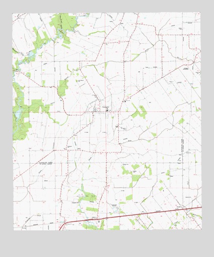
Chataignier, LA USGS Topographic Map
Click on map above to begin viewing in our Map Viewer.

This topographic map contains these locations and features:
Feature Name Type Latitude Longitude GNIS ID View Map
Atteles CemeteryCemeteryN30.6157°W92.2621°532245View Map
Bayou ChoupiqueStreamN30.5721°W92.3562°559908View Map
Bayou MarronStreamN30.5705°W92.3682°553491View Map
Beacons GullyStreamN30.5994°W92.3662°553542View Map
Carver Elementary School (historical)SchoolN30.5741°W92.2967°1629591View Map
Chatagnier Volunteer Fire DepartmentBuildingN30.5693°W92.3201°2332354View Map
ChataignierPopulated PlaceN30.5685°W92.3221°553956View Map
Chataignier CemeteryCemeteryN30.5163°W92.3321°1628696View Map
Chataignier CemeteryCemeteryN30.5469°W92.3396°542111View Map
Chataignier ChurchChurchN30.5474°W92.3396°533886View Map
Chataignier Elementary SchoolSchoolN30.5688°W92.3126°545682View Map
Chataignier Gas FieldOilfieldN30.5441°W92.3687°545681View Map
Chataignier Landing StripAirportN30.5919°W92.2571°545683View Map
Evangeline Parish Library Chataignier BranchBuildingN30.5693°W92.3209°2603059View Map
First Baptist ChurchChurchN30.5688°W92.3104°545691View Map
Fontenot CemeteryCemeteryN30.5185°W92.2568°1628697View Map
Fontenots GullyStreamN30.5924°W92.3724°552726View Map
Green Oak CemeteryCemeteryN30.5894°W92.2521°535391View Map
Guillory CemeteryCemeteryN30.5338°W92.2960°560916View Map
KIHG-FM (Mamou)TowerN30.5419°W92.3371°1633077View Map
Koch AirportAirportN30.5361°W92.3650°1632698View Map
Lake Hope Recreational ParkParkN30.6030°W92.3640°545702View Map
Leon Manuel CemeteryCemeteryN30.5863°W92.3326°536404View Map
Linzay Downs RacetrackLocaleN30.5121°W92.3076°1628699View Map
Macedonia ChurchChurchN30.5021°W92.3671°1627586View Map
Manuel CemeteryCemeteryN30.5377°W92.3010°1627605View Map
Mount Carmel CemeteryCemeteryN30.5591°W92.2998°537302View Map
New Zion ChurchChurchN30.5102°W92.2782°1627771View Map
North Savoy Oil FieldOilfieldN30.5752°W92.3065°545711View Map
Our Lady of Mount Carmel Catholic ChurchChurchN30.5660°W92.3215°545713View Map
Parish Governing Authority District 1CivilN30.6008°W92.2892°1929735View Map
Pine Point GullyStreamN30.6163°W92.3426°538190View Map
Saint Joseph Baptist ChurchChurchN30.5783°W92.3196°553298View Map
Saint Julien ChapelChurchN30.5599°W92.3040°538930View Map
Saint Mary ChurchChurchN30.6127°W92.2793°538974View Map
Saint Thomas ChurchChurchN30.5038°W92.3404°1628158View Map
SavoyPopulated PlaceN30.5074°W92.3196°1628180View Map
Savoy Oil and Gas FieldOilfieldN30.5058°W92.2846°1628182View Map
SwordsPopulated PlaceN30.5127°W92.2623°1628321View Map
Verret CemeteryCemeteryN30.5441°W92.2607°1628428View Map
Village of ChataignierCivilN30.5696°W92.3168°2407429View Map

Note: Coordinates in the location and feature list above are referenced to NAD83 datum.


Copyright (C) 2008-2024 Ryan Niemi / Sunset Dynamics ... All Rights Reserved