TopoQuest Logo
Do you find TopoQuest useful?
Help keep TopoQuest running and adding new maps/features by donating!
Bitcoin:  19c7KJd3qBynnjoSw5npx9KScwjBe4ifkT
Litecoin:  LXs6TkuXGGXo1vDsWCkWVdjQX94eUKd6ui
Home View Maps Find Maps Find Places Resources & Links


Mamou, Louisiana Topographic Map

USGS Map Title: Mamou, LA
USGS Map MRC: 30092F4
DRG (GeoTIFF) Download: o30092f4.tif


Neighboring USGS Topographic Map Quads:


  Beaver, LA  
30092G5
 

  Pine Prairie, LA  
30092G4
 

  Saint Landry, LA  
30092G3
 

  Bond, LA  
30092F5
 

  Mamou, LA  
30092F4
 

  Ville Platte, LA  
30092F3
 

  Duralde, LA  
30092E5
 

  Eunice North, LA  
30092E4
 

  Chataignier, LA  
30092E3


Map MRC Location:

N31°
W93°
N31°
W92°
H8 H7 H6 H5 H4 H3 H2 H1
G8 G7 G6 G5 G4 G3 G2 G1
F8 F7 F6 F5 F4 F3 F2 F1
E8 E7 E6 E5 E4 E3 E2 E1
D8 D7 D6 D5 D4 D3 D2 D1
C8 C7 C6 C5 C4 C3 C2 C1
B8 B7 B6 B5 B4 B3 B2 B1
A8 A7 A6 A5 A4 A3 A2 A1
N30°
W93°
N30°
W92°

Mamou, LA USGS 1:24K Topographic Map Preview:
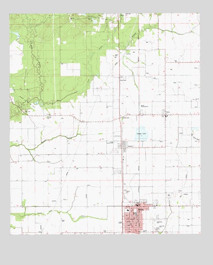
Mamou, LA USGS Topographic Map
Click on map above to begin viewing in our Map Viewer.

This topographic map contains these locations and features:
Feature Name Type Latitude Longitude GNIS ID View Map
Ardoin CemeteryCemeteryN30.6332°W92.4665°532207View Map
Barber SpurPopulated PlaceN30.6910°W92.4268°541049View Map
Boggy BayouStreamN30.7027°W92.4796°533287View Map
Central Farmers Coop AirportAirportN30.6961°W92.4152°1632840View Map
Chapel of the Holy SpiritChurchN30.6938°W92.3955°2601454View Map
Clandreneau ParkParkN30.6321°W92.4057°542112View Map
Community CemeteryCemeteryN30.6298°W92.4029°542113View Map
Evangeline Central SchoolSchoolN30.6933°W92.3817°545687View Map
Evangeline Extended Care Hospital MamouHospitalN30.6423°W92.4177°2674140View Map
Evangeline ParishCivilN30.7289°W92.4059°558551View Map
Evangeline Parish Library Mamou BranchBuildingN30.6298°W92.4245°2603060View Map
Evangeline Parish Police JuryBuildingN30.6263°W92.4083°2334099View Map
First Baptist ChurchChurchN30.6727°W92.4249°545692View Map
First Baptist ChurchChurchN30.6352°W92.4168°545693View Map
Gray PointPopulated PlaceN30.7138°W92.4282°543256View Map
Kids Korner Day Care CenterSchoolN30.6267°W92.4228°2600094View Map
Lahaye LakeReservoirN30.6822°W92.4090°554971View Map
Lahaye Lake DamDamN30.6785°W92.4132°556977View Map
Louisiana Noname 104 DamDamN30.7302°W92.4918°556975View Map
MamouPopulated PlaceN30.6338°W92.4193°543438View Map
Mamou Church of ChristChurchN30.6277°W92.4182°545705View Map
Mamou Elementary SchoolSchoolN30.6388°W92.4228°553935View Map
Mamou Head Start SchoolSchoolN30.6387°W92.4226°2600133View Map
Mamou High SchoolSchoolN30.6369°W92.4179°545706View Map
Mamou Lower Elementary School (historical)SchoolN30.6360°W92.4180°545707View Map
Mamou Oil FieldOilfieldN30.6446°W92.3893°536871View Map
Mamou Police DepartmentBuildingN30.6303°W92.4205°2333965View Map
Mamou Volunteer Fire DepartmentBuildingN30.6304°W92.4246°2332388View Map
Mamou Wastewater Treatment FacilityLocaleN30.6325°W92.4289°2603468View Map
Ortego CemeteryCemeteryN30.7266°W92.4312°537902View Map
Parish Governing Authority District 3CivilN30.7056°W92.4534°1929951View Map
Perron CemeteryCemeteryN30.6268°W92.4369°537982View Map
Pine Prairie Oil and Gas FieldOilfieldN30.7494°W92.4390°555662View Map
Pinseclair CemeteryCemeteryN30.6919°W92.4760°538206View Map
Platin CemeteryCemeteryN30.7232°W92.3896°538233View Map
ReddellPopulated PlaceN30.6741°W92.4262°555774View Map
Reddell Census Designated PlaceCensusN30.6687°W92.4268°2586705View Map
Reddell Oil and Gas FieldOilfieldN30.6860°W92.4899°538533View Map
Reddell Post OfficePost OfficeN30.6752°W92.4274°1630298View Map
Saint Ann Catholic ChurchChurchN30.6341°W92.4187°545722View Map
Saint Anns New CemeteryCemeteryN30.6493°W92.4248°542119View Map
Saint Anns Old CemeteryCemeteryN30.6271°W92.4135°538801View Map
Saint Luke Baptist ChurchChurchN30.6399°W92.4241°2602689View Map
Saint Paul Baptist ChurchChurchN30.6399°W92.4204°2602729View Map
Saint Teresa ChurchChurchN30.6933°W92.4735°539074View Map
Savoy Care CenterBuildingN30.6436°W92.4157°2601126View Map
Savoy Medical CenterHospitalN30.6423°W92.4179°555983View Map
Town of MamouCivilN30.6349°W92.4179°2406085View Map
VidrinePopulated PlaceN30.6927°W92.3982°540166View Map
Vidrine Elementary SchoolSchoolN30.6922°W92.3978°545727View Map
Ward ThreeCivilN30.6416°W92.4274°545023View Map
Zion Baptist ChurchChurchN30.6383°W92.4204°545736View Map

Note: Coordinates in the location and feature list above are referenced to NAD83 datum.


Copyright (C) 2008-2024 Ryan Niemi / Sunset Dynamics ... All Rights Reserved