TopoQuest Logo
Do you find TopoQuest useful?
Help keep TopoQuest running and adding new maps/features by donating!
Bitcoin:  19c7KJd3qBynnjoSw5npx9KScwjBe4ifkT
Litecoin:  LXs6TkuXGGXo1vDsWCkWVdjQX94eUKd6ui
Home View Maps Find Maps Find Places Resources & Links


Chinquapin, North Carolina Topographic Map

USGS Map Title: Chinquapin, NC
USGS Map MRC: 34077G7
DRG (GeoTIFF) Download: o34077g7.tif


Neighboring USGS Topographic Map Quads:


  Kenansville, NC  
34077H8
 

  Beulaville, NC  
34077H7
 

  Potters Hill, NC  
34077H6
 

  Charity, NC  
34077G8
 

  Chinquapin, NC  
34077G7
 

  Lyman, NC  
34077G6
 

  Wallace East, NC  
34077F8
 

  Pin Hook, NC  
34077F7
 

  Maple Hill, NC  
34077F6


Map MRC Location:

N35°
W78°
N35°
W77°
H8 H7 H6 H5 H4 H3 H2 H1
G8 G7 G6 G5 G4 G3 G2 G1
F8 F7 F6 F5 F4 F3 F2 F1
E8 E7 E6 E5 E4 E3 E2 E1
D8 D7 D6 D5 D4 D3 D2 D1
C8 C7 C6 C5 C4 C3 C2 C1
B8 B7 B6 B5 B4 B3 B2 B1
A8 A7 A6 A5 A4 A3 A2 A1
N34°
W78°
N34°
W77°

Chinquapin, NC USGS 1:24K Topographic Map Preview:
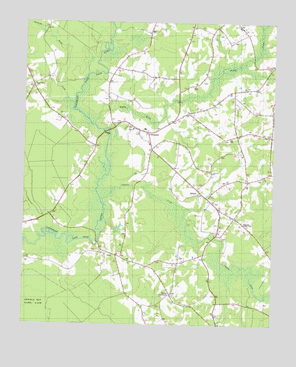
Chinquapin, NC USGS Topographic Map
Click on map above to begin viewing in our Map Viewer.

This topographic map contains these locations and features:
Feature Name Type Latitude Longitude GNIS ID View Map
Bethel ChurchChurchN34.8571°W77.7514°1026152View Map
ChinquapinPopulated PlaceN34.8310°W77.8164°1019667View Map
Chinquapin Elementary SchoolSchoolN34.8310°W77.8144°1001125View Map
Chinquapin II Elementary SchoolSchoolN34.8249°W77.8122°1001126View Map
Chinquapin Lookout TowerTowerN34.7921°W77.7647°1026156View Map
Chinquapin Post OfficePost OfficeN34.8312°W77.8183°2774325View Map
Chinquapin Volunteer Fire and RescueBuildingN34.8327°W77.8207°2638770View Map
Coles ChapelChurchN34.8274°W77.7708°1026154View Map
Cypress CreekStreamN34.7954°W77.8353°983888View Map
Duplin County Emergency Medical Services Medic 3BuildingN34.8327°W77.8207°2720487View Map
First Baptist ChurchChurchN34.8254°W77.8122°985083View Map
Laniers ChapelChurchN34.7868°W77.7525°1026153View Map
MareadyPopulated PlaceN34.8060°W77.7875°1025508View Map
Mount Horeb ChurchChurchN34.8132°W77.7797°1026155View Map
Muddy CreekStreamN34.8327°W77.8397°1025565View Map
Oak Dale ChurchChurchN34.7627°W77.8000°1026322View Map
Saint Louis Baptist ChurchChurchN34.8249°W77.8071°2505651View Map
Sharon ChurchChurchN34.8313°W77.8203°1026151View Map
Shiloh Baptist ChurchChurchN34.7972°W77.7762°2506268View Map
Sholars CrossroadsPopulated PlaceN34.7621°W77.8008°1025697View Map
SloanPopulated PlaceN34.7782°W77.8291°1025708View Map
Stephens SwampStreamN34.8735°W77.7561°1026302View Map
Stocking Head CreekStreamN34.8410°W77.8500°1025729View Map
Township of Cypress CreekCivilN34.7842°W77.7579°1026640View Map

Note: Coordinates in the location and feature list above are referenced to NAD83 datum.


Copyright (C) 2008-2024 Ryan Niemi / Sunset Dynamics ... All Rights Reserved