TopoQuest Logo
Do you find TopoQuest useful?
Help keep TopoQuest running and adding new maps/features by donating!
Bitcoin:  19c7KJd3qBynnjoSw5npx9KScwjBe4ifkT
Litecoin:  LXs6TkuXGGXo1vDsWCkWVdjQX94eUKd6ui
Home View Maps Find Maps Find Places Resources & Links


Charity, North Carolina Topographic Map

USGS Map Title: Charity, NC
USGS Map MRC: 34077G8
DRG (GeoTIFF) Download: o34077g8.tif


Neighboring USGS Topographic Map Quads:


  Warsaw South, NC  
34078H1
 

  Kenansville, NC  
34077H8
 

  Beulaville, NC  
34077H7
 

  Rose Hill, NC  
34078G1
 

  Charity, NC  
34077G8
 

  Chinquapin, NC  
34077G7
 

  Wallace West, NC  
34078F1
 

  Wallace East, NC  
34077F8
 

  Pin Hook, NC  
34077F7


Map MRC Location:

N35°
W78°
N35°
W77°
H8 H7 H6 H5 H4 H3 H2 H1
G8 G7 G6 G5 G4 G3 G2 G1
F8 F7 F6 F5 F4 F3 F2 F1
E8 E7 E6 E5 E4 E3 E2 E1
D8 D7 D6 D5 D4 D3 D2 D1
C8 C7 C6 C5 C4 C3 C2 C1
B8 B7 B6 B5 B4 B3 B2 B1
A8 A7 A6 A5 A4 A3 A2 A1
N34°
W78°
N34°
W77°

Charity, NC USGS 1:24K Topographic Map Preview:
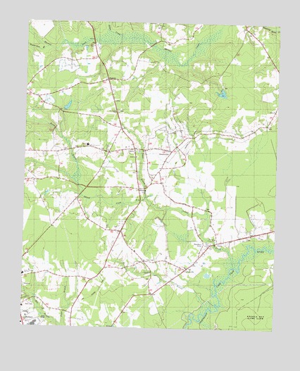
Charity, NC USGS Topographic Map
Click on map above to begin viewing in our Map Viewer.

This topographic map contains these locations and features:
Feature Name Type Latitude Longitude GNIS ID View Map
Beaverdam BranchStreamN34.8671°W77.9933°1025127View Map
Bethel ChurchChurchN34.8202°W77.9444°1004356View Map
CartersvillePopulated PlaceN34.7732°W77.9194°1019549View Map
CharityPopulated PlaceN34.8229°W77.9458°1019603View Map
Charity Junior High SchoolSchoolN34.8249°W77.9686°1004355View Map
Charity Methodist ChurchChurchN34.8229°W77.9450°1008031View Map
Clay Hill CemeteryCemeteryN34.8138°W77.9441°1008030View Map
Cooks BranchStreamN34.8029°W77.9389°1025254View Map
Elder ChapelChurchN34.8654°W77.9667°1004353View Map
Elder CreekStreamN34.8691°W77.9455°1025304View Map
Golden Care Nursing HomeBuildingN34.7908°W77.8792°2505794View Map
GreeneversPopulated PlaceN34.8224°W77.9269°1004359View Map
Greenevers Police DepartmentBuildingN34.8230°W77.9310°2770020View Map
Greenevers Volunteer Fire DepartmentBuildingN34.8230°W77.9309°2638893View Map
Guiding Star ChurchChurchN34.8316°W77.9303°1004358View Map
Hancheys StorePopulated PlaceN34.7835°W77.9111°1025374View Map
Island CreekStreamN34.7743°W77.8950°987417View Map
Island Creek ChurchChurchN34.8246°W77.9672°1004354View Map
Island Creek ChurchChurchN34.8118°W77.9364°1004357View Map
Jones ChapelChurchN34.7632°W77.9364°987731View Map
MurpheyPopulated PlaceN34.8068°W77.9425°1021588View Map
New Christian ChapelChurchN34.8388°W77.9539°1004352View Map
Northeast ChurchChurchN34.7868°W77.9044°1004360View Map
Northeast Volunteer Fire DepartmentBuildingN34.7798°W77.9119°2638477View Map
Oakie BranchStreamN34.7566°W77.9105°1025590View Map
PasleyPopulated PlaceN34.7854°W77.9005°1021824View Map
Reedy BranchStreamN34.8041°W77.9717°993169View Map
RegisterPopulated PlaceN34.8516°W77.9594°1022854View Map
Teacheys StoreLocaleN34.8221°W77.9272°995908View Map
Town 'N' Country Shopping CenterLocaleN34.7516°W77.9989°1007270View Map
Town of GreeneversCivilN34.8271°W77.9246°2406612View Map
Township of Island CreekCivilN34.7894°W77.9262°1026643View Map
Wallace Rose Hill High SchoolSchoolN34.7712°W77.9997°1026157View Map
WLSE-AM (Wallace)TowerN34.7582°W77.9997°1018369View Map
WZKB-FM (Wallace)TowerN34.7582°W77.9997°1018624View Map
Xenia Post Office (historical)Post OfficeN34.8329°W77.9522°1008029View Map

Note: Coordinates in the location and feature list above are referenced to NAD83 datum.


Copyright (C) 2008-2024 Ryan Niemi / Sunset Dynamics ... All Rights Reserved