TopoQuest Logo
Do you find TopoQuest useful?
Help keep TopoQuest running and adding new maps/features by donating!
Bitcoin:  19c7KJd3qBynnjoSw5npx9KScwjBe4ifkT
Litecoin:  LXs6TkuXGGXo1vDsWCkWVdjQX94eUKd6ui
Home View Maps Find Maps Find Places Resources & Links


Clear Lake, Illinois Topographic Map

USGS Map Title: Clear Lake, IL
USGS Map MRC: 40090A3
DRG (GeoTIFF) Download: o40090a3.tif


Neighboring USGS Topographic Map Quads:


  Ray, IL  
40090B4
 

  Astoria, IL  
40090B3
 

  Bath, IL  
40090B2
 

  Beardstown, IL  
40090A4
 

  Clear Lake, IL  
40090A3
 

  Chandlerville, IL  
40090A2
 

  Arenzville West, IL  
39090H4
 

  Arenzville East, IL  
39090H3
 

  Virginia, IL  
39090H2


Map MRC Location:

N41°
W91°
N41°
W90°
H8 H7 H6 H5 H4 H3 H2 H1
G8 G7 G6 G5 G4 G3 G2 G1
F8 F7 F6 F5 F4 F3 F2 F1
E8 E7 E6 E5 E4 E3 E2 E1
D8 D7 D6 D5 D4 D3 D2 D1
C8 C7 C6 C5 C4 C3 C2 C1
B8 B7 B6 B5 B4 B3 B2 B1
A8 A7 A6 A5 A4 A3 A2 A1
N40°
W91°
N40°
W90°

Clear Lake, IL USGS 1:24K Topographic Map Preview:
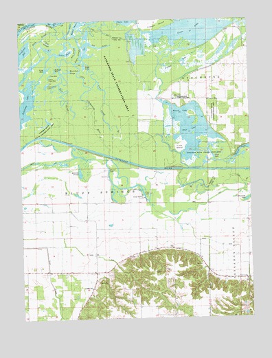
Clear Lake, IL USGS Topographic Map
Click on map above to begin viewing in our Map Viewer.

This topographic map contains these locations and features:
Feature Name Type Latitude Longitude GNIS ID View Map
Ash SwaleGutN40.1128°W90.3298°403667View Map
Bach SloughGutN40.1184°W90.3604°403782View Map
Beard CemeteryCemeteryN40.0131°W90.3418°1720385View Map
Brick Elementary SchoolSchoolN40.0192°W90.3348°404843View Map
Carp HoleLakeN40.1048°W90.3601°405619View Map
Carr CemeteryCemeteryN40.0227°W90.2807°1720395View Map
Clear LakeLakeN40.0516°W90.3087°1720400View Map
Clear LakePopulated PlaceN40.0506°W90.3090°406224View Map
Collis PondLakeN40.1125°W90.3515°406386View Map
Coon SloughStreamN40.1095°W90.3401°1720401View Map
Cottonwood LakeLakeN40.0494°W90.2520°406637View Map
Cottonwood School (historical)SchoolN40.0287°W90.3021°406641View Map
Crane LakeLakeN40.1200°W90.2816°406743View Map
Cross SloughLakeN40.1226°W90.2614°1821473View Map
Crow HoleLakeN40.1024°W90.3583°1720405View Map
Cuba IslandIslandN40.0720°W90.2879°1720406View Map
Duck SloughLakeN40.0941°W90.3493°407458View Map
Eagle LakeLakeN40.0998°W90.3325°1720410View Map
Eagle PrairieAreaN40.1125°W90.3357°1773032View Map
Eagle SloughGutN40.1120°W90.3407°407578View Map
Griggs Chapel (historical)ChurchN40.0456°W90.3487°409507View Map
Hager CemeteryCemeteryN40.0295°W90.2929°1720417View Map
Hickory School (historical)SchoolN40.0167°W90.2526°410185View Map
Hog SloughLakeN40.1157°W90.3524°410356View Map
Limbo School (historical)SchoolN40.0489°W90.3407°412097View Map
Little Sangamon RiverStreamN40.1164°W90.3426°412412View Map
Lost CreekStreamN40.0317°W90.3623°412644View Map
Lower Crow HoleLakeN40.1014°W90.3591°1720429View Map
McCarty SloughLakeN40.0614°W90.3429°1720430View Map
McKay FlatsFlatN40.1145°W90.3635°1773038View Map
Mound LakeLakeN40.0900°W90.2943°413913View Map
Otter LakeLakeN40.0785°W90.2800°415223View Map
Pinoak LakeLakeN40.1059°W90.2918°415721View Map
Point LakeLakeN40.0728°W90.2679°1720441View Map
Red Oak School (historical)SchoolN40.0050°W90.2912°416460View Map
Redhead LakeLakeN40.1041°W90.3555°1720444View Map
River SwaleLakeN40.1245°W90.3321°424166View Map
Sand IslandIslandN40.0848°W90.2798°1821495View Map
Sangamon BayLakeN40.1104°W90.3740°418003View Map
Sangamon Valley ChurchChurchN40.0159°W90.2529°1720448View Map
Sanganois State Conservation AreaParkN40.1092°W90.3335°1720449View Map
Star School (historical)SchoolN40.0125°W90.3735°419049View Map
Swamp SloughGutN40.0656°W90.3640°1773047View Map
Toppers HoleLakeN40.0814°W90.3610°1773048View Map
Toppers Hole State Conservation AreaParkN40.0828°W90.3604°1720454View Map
Township of Bluff SpringsCivilN40.0342°W90.3360°428691View Map
Weiner SwaleLakeN40.1245°W90.3321°424527View Map
Wells CemeteryCemeteryN40.0598°W90.3279°1720462View Map
Wilcox LakeLakeN40.0668°W90.2586°421139View Map
Wood Duck SloughLakeN40.1035°W90.3486°1720466View Map

Note: Coordinates in the location and feature list above are referenced to NAD83 datum.


Copyright (C) 2008-2024 Ryan Niemi / Sunset Dynamics ... All Rights Reserved