TopoQuest Logo
Do you find TopoQuest useful?
Help keep TopoQuest running and adding new maps/features by donating!
Bitcoin:  19c7KJd3qBynnjoSw5npx9KScwjBe4ifkT
Litecoin:  LXs6TkuXGGXo1vDsWCkWVdjQX94eUKd6ui
Home View Maps Find Maps Find Places Resources & Links


Astoria, Illinois Topographic Map

USGS Map Title: Astoria, IL
USGS Map MRC: 40090B3
DRG (GeoTIFF) Download: o40090b3.tif


Neighboring USGS Topographic Map Quads:


  Vermont, IL  
40090C4
 

  Ipava, IL  
40090C3
 

  Duncan Mills, IL  
40090C2
 

  Ray, IL  
40090B4
 

  Astoria, IL  
40090B3
 

  Bath, IL  
40090B2
 

  Beardstown, IL  
40090A4
 

  Clear Lake, IL  
40090A3
 

  Chandlerville, IL  
40090A2


Map MRC Location:

N41°
W91°
N41°
W90°
H8 H7 H6 H5 H4 H3 H2 H1
G8 G7 G6 G5 G4 G3 G2 G1
F8 F7 F6 F5 F4 F3 F2 F1
E8 E7 E6 E5 E4 E3 E2 E1
D8 D7 D6 D5 D4 D3 D2 D1
C8 C7 C6 C5 C4 C3 C2 C1
B8 B7 B6 B5 B4 B3 B2 B1
A8 A7 A6 A5 A4 A3 A2 A1
N40°
W91°
N40°
W90°

Astoria, IL USGS 1:24K Topographic Map Preview:
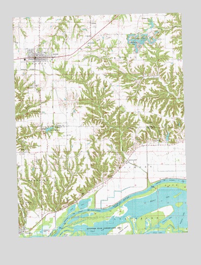
Astoria, IL USGS Topographic Map
Click on map above to begin viewing in our Map Viewer.

This topographic map contains these locations and features:
Feature Name Type Latitude Longitude GNIS ID View Map
AstoriaPopulated PlaceN40.2275°W90.3596°403689View Map
Astoria CemeteryCemeteryN40.2111°W90.3607°1747949View Map
Astoria Community High SchoolSchoolN40.2298°W90.3521°1802173View Map
Astoria Fire Protection District Station 1BuildingN40.2282°W90.3581°2640695View Map
Astoria Post OfficePost OfficeN40.2268°W90.3604°2788716View Map
BaderPopulated PlaceN40.1731°W90.3687°403793View Map
Bates CemeteryCemeteryN40.1489°W90.3282°1720646View Map
Bluff City CemeteryCemeteryN40.1817°W90.3385°1984418View Map
Briney LakeReservoirN40.1784°W90.2518°1692485View Map
Briney Lake DamDamN40.1784°W90.2518°1692484View Map
Briney Lake Dam Number 1DamN40.1767°W90.2635°1691984View Map
Briney Lake Number 1ReservoirN40.1798°W90.2632°1691985View Map
BrowningPopulated PlaceN40.1289°W90.3721°404967View Map
Browning CemeteryCemeteryN40.1450°W90.3704°1720655View Map
Browning Elementary SchoolSchoolN40.1312°W90.3718°1821123View Map
Browning Fire DepartmentBuildingN40.1292°W90.3723°2640853View Map
Browning Post OfficePost OfficeN40.1292°W90.3717°2788741View Map
Camp Immanuel Lake DamDamN40.1867°W90.3535°1691982View Map
Chain LakeLakeN40.1284°W90.3187°405923View Map
Cooper School (historical)SchoolN40.2225°W90.2637°406557View Map
Crossroads School (historical)SchoolN40.1728°W90.3526°406839View Map
Dixon BranchStreamN40.1767°W90.2621°407251View Map
Dunkard Brethren ChurchChurchN40.1959°W90.3571°1747952View Map
Dutchmans CreekStreamN40.1253°W90.3665°407543View Map
Dutchmans LakeLakeN40.1296°W90.3553°407544View Map
Elm CreekStreamN40.1545°W90.2735°407917View Map
Elm IslandIslandN40.1278°W90.3490°407930View Map
Emmanuel LakeReservoirN40.1860°W90.3506°1720668View Map
Good Hope School (historical)SchoolN40.1953°W90.3435°1802171View Map
Hickory IslandIslandN40.1350°W90.3287°410173View Map
Hickory School (historical)SchoolN40.1673°W90.3204°410186View Map
Hickory SloughLakeN40.1366°W90.3263°410191View Map
Ingram LakeLakeN40.1325°W90.2668°410902View Map
Izaac Walton ParkParkN40.2317°W90.2868°1747957View Map
J R Briney and Sons Airport (historical)AirportN40.1695°W90.2904°427087View Map
Jones CemeteryCemeteryN40.1725°W90.3048°1720691View Map
Knapps IslandIslandN40.1262°W90.3012°411570View Map
Lake AnnReservoirN40.1866°W90.2541°1747948View Map
Lakeview School (historical)SchoolN40.1281°W90.2926°411763View Map
LeesburgPopulated PlaceN40.2473°W90.3173°411919View Map
Long LakeLakeN40.1435°W90.3256°412578View Map
Lookout School (historical)SchoolN40.1981°W90.2843°412626View Map
McClung School (historical)SchoolN40.1978°W90.3132°413205View Map
Motes Chapel (historical)ChurchN40.1934°W90.2690°413890View Map
Mount Zion CemeteryCemeteryN40.2245°W90.2532°1773351View Map
Mount Zion Primitive Baptist ChurchChurchN40.2237°W90.2537°414140View Map
Mud Valley ChurchChurchN40.1817°W90.3379°414204View Map
Old Order Baptist Brethren CemeteryCemeteryN40.1820°W90.3385°1984580View Map
Panther SloughGutN40.1308°W90.3391°2083720View Map
Price CemeteryCemeteryN40.1781°W90.2679°1720716View Map
Salisbury CemeteryCemeteryN40.1853°W90.2879°1720722View Map
School Number 16 (historical)SchoolN40.2459°W90.2821°425457View Map
Sharps LandingLocaleN40.1525°W90.2765°1720730View Map
Sheldon's Grove CemeteryCemeteryN40.1686°W90.2979°1984581View Map
Sheldons GrovePopulated PlaceN40.1667°W90.2943°418340View Map
Skiles BranchStreamN40.1609°W90.2710°418568View Map
South Fulton CemeteryCemeteryN40.1956°W90.3579°1773367View Map
Stewart LakeLakeN40.1445°W90.2729°419128View Map
Sugar Grove Church (historical)ChurchN40.2025°W90.3557°419308View Map
Sugar Grove School (historical)SchoolN40.2028°W90.3560°1802170View Map
Summum Sixteen CemeteryCemeteryN40.2473°W90.2790°1747963View Map
Town of AstoriaCivilN40.2279°W90.3565°2398002View Map
Township of HickoryCivilN40.1663°W90.2766°429132View Map
Township of WoodlandCivilN40.2305°W90.2778°429952View Map
Village of BrowningCivilN40.1271°W90.3730°2397471View Map
Woodland CemeteryCemeteryN40.2378°W90.3171°1802172View Map
Woodland Church of the BrethrenChurchN40.2389°W90.3176°421435View Map

Note: Coordinates in the location and feature list above are referenced to NAD83 datum.


Copyright (C) 2008-2024 Ryan Niemi / Sunset Dynamics ... All Rights Reserved