TopoQuest Logo
Do you find TopoQuest useful?
Help keep TopoQuest running and adding new maps/features by donating!
Bitcoin:  19c7KJd3qBynnjoSw5npx9KScwjBe4ifkT
Litecoin:  LXs6TkuXGGXo1vDsWCkWVdjQX94eUKd6ui
Home View Maps Find Maps Find Places Resources & Links


Copper Mountain, Arizona Topographic Map

USGS Map Title: Copper Mountain, AZ
USGS Map MRC: 33111H1
DRG (GeoTIFF) Download: o33111h1.tif


Neighboring USGS Topographic Map Quads:


  Sheep Basin Mountain, AZ  
34111A2
 

  Buzzard Roost Mesa, AZ  
34111A1
 

  Young, AZ  
34110A8
 

  Picture Mountain, AZ  
33111H2
 

  Copper Mountain, AZ  
33111H1
 

  McFadden Peak, AZ  
33110H8
 

  Greenback Creek, AZ  
33111G2
 

  Armer Mountain, AZ  
33111G1
 

  Aztec Peak, AZ  
33110G8


Map MRC Location:

N34°
W112°
N34°
W111°
H8 H7 H6 H5 H4 H3 H2 H1
G8 G7 G6 G5 G4 G3 G2 G1
F8 F7 F6 F5 F4 F3 F2 F1
E8 E7 E6 E5 E4 E3 E2 E1
D8 D7 D6 D5 D4 D3 D2 D1
C8 C7 C6 C5 C4 C3 C2 C1
B8 B7 B6 B5 B4 B3 B2 B1
A8 A7 A6 A5 A4 A3 A2 A1
N33°
W112°
N33°
W111°

Copper Mountain, AZ USGS 1:24K Topographic Map Preview:
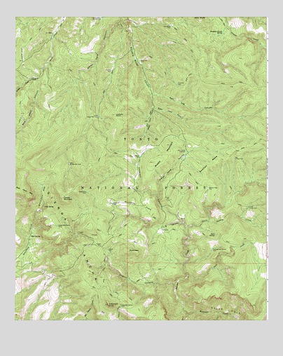
Copper Mountain, AZ USGS Topographic Map
Click on map above to begin viewing in our Map Viewer.

This topographic map contains these locations and features:
Feature Name Type Latitude Longitude GNIS ID View Map
Bear Head CanyonValleyN33.9750°W111.1132°26092View Map
Big Turkey TankReservoirN33.9417°W111.0162°26309View Map
Buck PeakSummitN33.9034°W111.0687°26872View Map
Buckaroo FlatsFlatN33.9223°W111.0637°26892View Map
Buckaroo TankReservoirN33.9232°W111.0769°26893View Map
Cataract CanyonValleyN33.9148°W111.0415°27361View Map
Cataract TankReservoirN33.9425°W111.0631°27365View Map
Copper MountainSummitN33.9250°W111.1015°27927View Map
Copper Mountain Points TankReservoirN33.9140°W111.1048°27929View Map
Copper Mountain TankReservoirN33.9277°W111.0898°27930View Map
Dupont CabinLocaleN33.9056°W111.0826°28677View Map
Dupont CanyonValleyN33.8892°W111.0468°28678View Map
Dupont TankReservoirN33.9039°W111.0791°28679View Map
East Lacy ForkValleyN33.9631°W111.0573°28771View Map
Elephant Corral SpringSpringN33.9936°W111.0224°28847View Map
Greenback PeakSummitN33.8812°W111.0793°29584View Map
Greenback Saddle TankReservoirN33.8809°W111.0726°29585View Map
Headquarters Pasture TankReservoirN33.9995°W111.0828°29834View Map
Hells HoleValleyN33.8817°W111.0415°29874View Map
Indian Camp CanyonValleyN33.9267°W111.0537°30328View Map
Indian Camp ReservoirReservoirN33.9447°W111.0402°30329View Map
J R CanyonValleyN33.9148°W111.0415°30448View Map
J R RanchLocaleN33.9123°W111.0532°30449View Map
J Slash X RanchLocaleN33.9750°W111.1162°30450View Map
Jakes Tank CanyonValleyN33.9992°W111.0729°30494View Map
Jerky Butte TankReservoirN33.9962°W111.0480°30520View Map
Lion SpringSpringN33.9220°W111.1106°31017View Map
Little Copper Mountain TankReservoirN33.9589°W111.0840°31052View Map
Little Turkey CreekStreamN33.9159°W111.0293°31140View Map
Little Turkey TankReservoirN33.9216°W111.0094°31141View Map
Long Mesa TankReservoirN33.8855°W111.1087°39576View Map
Lookout PointSummitN33.9595°W111.0760°31277View Map
Malicious GapGapN33.9253°W111.1126°31465View Map
McBride TankReservoirN33.9778°W111.0777°31621View Map
Middle MountainSummitN33.9473°W111.0507°31819View Map
Mud SpringSpringN33.9098°W111.1172°32108View Map
Park CreekStreamN33.8928°W111.0398°32684View Map
Peach Hollow TankReservoirN33.9959°W111.0643°39690View Map
Pine Flat TankReservoirN33.9819°W111.0631°32938View Map
Pine Mountain TankReservoirN33.9721°W111.0448°32958View Map
Redman MesaSummitN33.9356°W111.0323°33533View Map
Redman Mesa TankReservoirN33.9292°W111.0295°33534View Map
Rock SpringSpringN33.9104°W111.0263°33724View Map
Salome CreekStreamN33.9159°W111.0293°33979View Map
Salt Log CanyonValleyN33.9687°W111.0579°33994View Map
Thoroughbred Pasture TankReservoirN33.9042°W111.0276°35291View Map
Tonto Basin DivisionCivilN33.9289°W111.0573°1934984View Map
Turkey CreekStreamN33.9159°W111.0293°40778View Map
Turkey CreekStreamN33.9750°W111.1132°35546View Map
West Copper Mountain TankReservoirN33.9394°W111.0981°35973View Map
West Lacy ForkValleyN33.9631°W111.0573°36002View Map
Workman CreekStreamN33.8773°W111.0393°36399View Map
Z T RanchLocaleN33.9931°W111.1068°36498View Map

Note: Coordinates in the location and feature list above are referenced to NAD83 datum.


Copyright (C) 2008-2024 Ryan Niemi / Sunset Dynamics ... All Rights Reserved