TopoQuest Logo
Do you find TopoQuest useful?
Help keep TopoQuest running and adding new maps/features by donating!
Bitcoin:  19c7KJd3qBynnjoSw5npx9KScwjBe4ifkT
Litecoin:  LXs6TkuXGGXo1vDsWCkWVdjQX94eUKd6ui
Home View Maps Find Maps Find Places Resources & Links


McFadden Peak, Arizona Topographic Map

USGS Map Title: McFadden Peak, AZ
USGS Map MRC: 33110H8
DRG (GeoTIFF) Download: o33110h8.tif


Neighboring USGS Topographic Map Quads:


  Buzzard Roost Mesa, AZ  
34111A1
 

  Young, AZ  
34110A8
 

  Gentry Mountain, AZ  
34110A7
 

  Copper Mountain, AZ  
33111H1
 

  McFadden Peak, AZ  
33110H8
 

  Rock House, AZ  
33110H7
 

  Armer Mountain, AZ  
33111G1
 

  Aztec Peak, AZ  
33110G8
 

  Sombrero Peak, AZ  
33110G7


Map MRC Location:

N34°
W111°
N34°
W110°
H8 H7 H6 H5 H4 H3 H2 H1
G8 G7 G6 G5 G4 G3 G2 G1
F8 F7 F6 F5 F4 F3 F2 F1
E8 E7 E6 E5 E4 E3 E2 E1
D8 D7 D6 D5 D4 D3 D2 D1
C8 C7 C6 C5 C4 C3 C2 C1
B8 B7 B6 B5 B4 B3 B2 B1
A8 A7 A6 A5 A4 A3 A2 A1
N33°
W111°
N33°
W110°

McFadden Peak, AZ USGS 1:24K Topographic Map Preview:
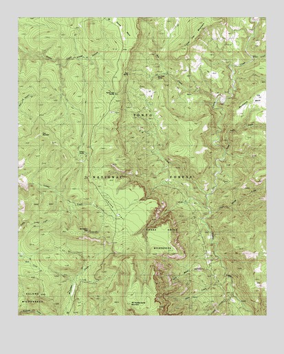
McFadden Peak, AZ USGS Topographic Map
Click on map above to begin viewing in our Map Viewer.

This topographic map contains these locations and features:
Feature Name Type Latitude Longitude GNIS ID View Map
Ash CreekStreamN33.9650°W110.9015°25785View Map
Ash Creek Corral SpringSpringN33.8925°W110.9290°39234View Map
Ash Creek SpringSpringN33.9765°W110.9253°39235View Map
Billy Lawrence CanyonValleyN33.8753°W110.8829°39262View Map
Billy Lawrence CreekStreamN33.8753°W110.8829°39263View Map
Board Tree SaddleGapN33.9675°W110.9521°26558View Map
Board Tree Saddle TankReservoirN33.9592°W110.9540°39277View Map
Board Tree SpringSpringN33.9763°W110.9451°39278View Map
China Spring CreekStreamN33.9184°W110.9046°27595View Map
China Spring TankReservoirN33.9057°W110.8790°39346View Map
Chinaman TankReservoirN33.9223°W110.8910°39347View Map
Circle RanchLocaleN33.8887°W110.9726°27669View Map
Cold Water CanyonValleyN33.8984°W110.8993°39366View Map
Cow Flat MountainSummitN33.9845°W110.9179°28086View Map
Cow Flat TankReservoirN33.9950°W110.9221°40903View Map
Dads TankReservoirN33.9639°W110.9173°39395View Map
Deep CreekStreamN33.8917°W110.8951°39403View Map
East Spear CreekStreamN33.9800°W110.9798°39431View Map
Elephant RockArchN33.8972°W110.9331°1678946View Map
Gold CreekStreamN33.8848°W110.8923°39464View Map
Gunsight TankReservoirN33.9467°W110.8835°22337View Map
Horse Mountain TankReservoirN33.9456°W110.9182°39519View Map
Horse Tank CreekStreamN33.9437°W110.8973°30175View Map
Juniper FlatFlatN33.9189°W110.9493°30657View Map
Juniper Flat TankReservoirN33.9189°W110.9487°39551View Map
McFadden Horse MountainSummitN33.8800°W110.9437°39597View Map
McFadden PeakSummitN33.9100°W110.9660°31662View Map
McFadden Peak LookoutTowerN33.9103°W110.9660°39598View Map
Olliger Mesa TankReservoirN33.9820°W110.9076°39671View Map
P B CreekStreamN33.9256°W110.9062°32602View Map
P B RanchLocaleN33.9367°W110.9262°32603View Map
P B SpringSpringN33.9356°W110.9290°39675View Map
Park TankReservoirN33.9023°W110.9979°39677View Map
Paul TankReservoirN33.9945°W110.9679°39681View Map
Pendleton MesaSummitN33.9678°W110.8804°32783View Map
Pendleton TankReservoirN33.9613°W110.8751°41328View Map
Pine MountainSummitN33.9506°W110.9885°32951View Map
Reg TankReservoirN33.9961°W110.9691°39731View Map
Rhinehart TankReservoirN33.9727°W110.9657°2060996View Map
Turkey SpringSpringN33.9431°W110.9679°35570View Map
Wilson CreekStreamN33.9825°W110.8835°36288View Map

Note: Coordinates in the location and feature list above are referenced to NAD83 datum.


Copyright (C) 2008-2024 Ryan Niemi / Sunset Dynamics ... All Rights Reserved