TopoQuest Logo
Do you find TopoQuest useful?
Help keep TopoQuest running and adding new maps/features by donating!
Bitcoin:  19c7KJd3qBynnjoSw5npx9KScwjBe4ifkT
Litecoin:  LXs6TkuXGGXo1vDsWCkWVdjQX94eUKd6ui
Home View Maps Find Maps Find Places Resources & Links


Cordova, Illinois Topographic Map

USGS Map Title: Cordova, IL
USGS Map MRC: 41090F3
DRG (GeoTIFF) Download: o41090f3.tif


Neighboring USGS Topographic Map Quads:


  Malone, IA  
41090G4
 

  Camanche, IA  
41090G3
 

  Clinton, IA  
41090G2
 

  McCausland, IA  
41090F4
 

  Cordova, IL  
41090F3
 

  Erie NW, IL  
41090F2
 

  Silvis, IL  
41090E4
 

  Port Byron, IL  
41090E3
 

  Hillsdale, IL  
41090E2


Map MRC Location:

N42°
W91°
N42°
W90°
H8 H7 H6 H5 H4 H3 H2 H1
G8 G7 G6 G5 G4 G3 G2 G1
F8 F7 F6 F5 F4 F3 F2 F1
E8 E7 E6 E5 E4 E3 E2 E1
D8 D7 D6 D5 D4 D3 D2 D1
C8 C7 C6 C5 C4 C3 C2 C1
B8 B7 B6 B5 B4 B3 B2 B1
A8 A7 A6 A5 A4 A3 A2 A1
N41°
W91°
N41°
W90°

Cordova, IL USGS 1:24K Topographic Map Preview:
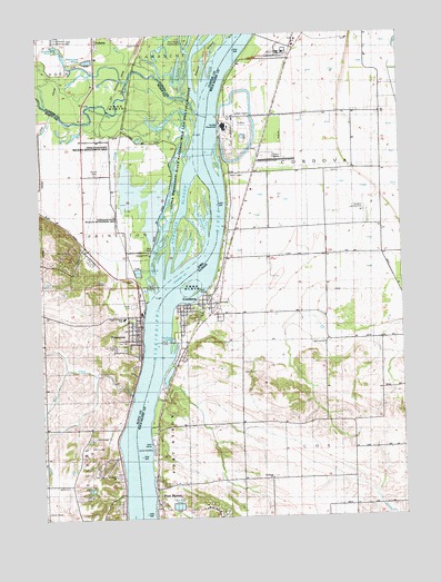
Cordova, IL USGS Topographic Map
Click on map above to begin viewing in our Map Viewer.

This topographic map contains these locations and features:
Feature Name Type Latitude Longitude GNIS ID View Map
Adams IslandIslandN41.7443°W90.3183°454091View Map
Baker CemeteryCemeteryN41.6628°W90.3054°403823View Map
Ben Martinsen AreaParkN41.7473°W90.3696°2000624View Map
Bud CreekStreamN41.6570°W90.3437°454944View Map
Camp HaubergLocaleN41.6439°W90.3371°405472View Map
City of PrincetonCivilN41.6743°W90.3572°2396280View Map
CordovaPopulated PlaceN41.6803°W90.3190°406583View Map
Cordova DragwayLocaleN41.7173°W90.2932°1718935View Map
Cordova Fire Protection DistrictBuildingN41.6801°W90.3187°2640160View Map
Cordova Police DepartmentBuildingN41.6800°W90.3185°2756750View Map
Cordova Post OfficePost OfficeN41.6806°W90.3176°2788432View Map
Cordova SloughGutN41.7043°W90.3259°2730074View Map
Cordova SloughStreamN41.6875°W90.3304°455626View Map
Fairfield CemeteryCemeteryN41.6342°W90.2971°1967989View Map
Fairfield ChurchChurchN41.6353°W90.2962°408167View Map
FollettsPopulated PlaceN41.7486°W90.3549°456655View Map
Grant SloughGutN41.6977°W90.3330°2747100View Map
Grassy Lane School (historical)SchoolN41.7134°W90.3543°465087View Map
Hagenson PondReservoirN41.7435°W90.3571°2000861View Map
Hagenson Pond AreaParkN41.7439°W90.3585°2000623View Map
Jacks CemeteryCemeteryN41.6335°W90.3661°457884View Map
Lost CreekStreamN41.7306°W90.3690°458623View Map
Lund CreekStreamN41.6494°W90.3467°2071690View Map
Nowlan CemeteryCemeteryN41.7142°W90.3554°459675View Map
Oak Ridge CemeteryCemeteryN41.6690°W90.3496°459734View Map
Olathea Golf CourseLocaleN41.6445°W90.3571°2046522View Map
Old School ParkParkN41.6745°W90.3430°2084104View Map
Our Lady of the River ChurchChurchN41.6361°W90.3504°2046521View Map
Preeminent School (historical)SchoolN41.6711°W90.2515°424088View Map
PrincetonLocaleN41.6806°W90.3404°2046483View Map
PrincetonPopulated PlaceN41.6748°W90.3404°460455View Map
Princeton City CemeteryCemeteryN41.6700°W90.3450°2046589View Map
Princeton City HallBuildingN41.6756°W90.3424°2046480View Map
Princeton Fire DepartmentBuildingN41.6742°W90.3414°2577163View Map
Princeton LibraryBuildingN41.6764°W90.3401°2046478View Map
Princeton Police DepartmentBuildingN41.6752°W90.3421°2046479View Map
Princeton Post OfficePost OfficeN41.6806°W90.3415°2046481View Map
Princeton Presbyterian ChurchChurchN41.6717°W90.3426°2046485View Map
Princeton State Wildlife Management AreaParkN41.7070°W90.3379°466692View Map
Rivercrest EstatesPopulated PlaceN41.6800°W90.3432°2046482View Map
Scharff School (historical)SchoolN41.6420°W90.3624°465159View Map
Schricker SloughStreamN41.7336°W90.3196°461478View Map
Shaff LakeLakeN41.7456°W90.3339°2730071View Map
Shaffton QuarryMineN41.7494°W90.3397°2571529View Map
Sodus CreekStreamN41.7431°W90.3215°461738View Map
The Sandbox Airport (historical)AirportN41.7042°W90.2614°427187View Map
Township of CoeCivilN41.6274°W90.2671°428826View Map
Township of CordovaCivilN41.7148°W90.2756°428844View Map
Township of Port ByronCivilN41.6257°W90.3332°429592View Map
Village of CordovaCivilN41.6773°W90.3215°2398626View Map
Virgil Grissom Elementary SchoolSchoolN41.6767°W90.3464°2046486View Map
Wapsipinicon RiverStreamN41.7297°W90.3198°462671View Map
Water Tower ParkParkN41.6706°W90.3480°2084103View Map
Whiskey Run CreekStreamN41.6747°W90.3397°2071330View Map
Williams School (historical)SchoolN41.7298°W90.2568°424109View Map
Zion Lutheran ChurchChurchN41.6764°W90.3412°2046484View Map

Note: Coordinates in the location and feature list above are referenced to NAD83 datum.


Copyright (C) 2008-2024 Ryan Niemi / Sunset Dynamics ... All Rights Reserved