TopoQuest Logo
Do you find TopoQuest useful?
Help keep TopoQuest running and adding new maps/features by donating!
Bitcoin:  19c7KJd3qBynnjoSw5npx9KScwjBe4ifkT
Litecoin:  LXs6TkuXGGXo1vDsWCkWVdjQX94eUKd6ui
Home View Maps Find Maps Find Places Resources & Links


Crestline, Kansas Topographic Map

USGS Map Title: Crestline, KS
USGS Map MRC: 37094B6
DRG (GeoTIFF) Download: o37094b6.tif


Neighboring USGS Topographic Map Quads:


  Cherokee, KS  
37094C7
 

  Kirkwood, KS  
37094C6
 

  Asbury, MO  
37094C5
 

  Columbus, KS  
37094B7
 

  Crestline, KS  
37094B6
 

  Carl Junction, MO  
37094B5
 

  Neutral, KS  
37094A7
 

  Baxter Springs, KS  
37094A6
 

  Joplin West, MO  
37094A5


Map MRC Location:

N38°
W95°
N38°
W94°
H8 H7 H6 H5 H4 H3 H2 H1
G8 G7 G6 G5 G4 G3 G2 G1
F8 F7 F6 F5 F4 F3 F2 F1
E8 E7 E6 E5 E4 E3 E2 E1
D8 D7 D6 D5 D4 D3 D2 D1
C8 C7 C6 C5 C4 C3 C2 C1
B8 B7 B6 B5 B4 B3 B2 B1
A8 A7 A6 A5 A4 A3 A2 A1
N37°
W95°
N37°
W94°

Crestline, KS USGS 1:24K Topographic Map Preview:
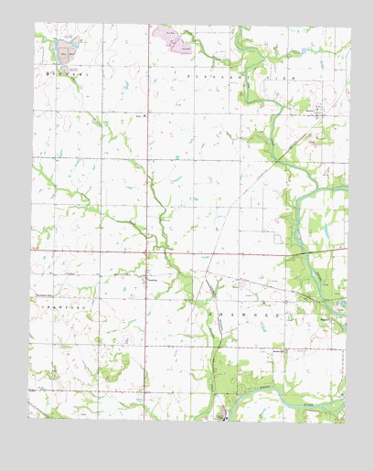
Crestline, KS USGS Topographic Map
Click on map above to begin viewing in our Map Viewer.

This topographic map contains these locations and features:
Feature Name Type Latitude Longitude GNIS ID View Map
BadgerPopulated PlaceN37.1584°W94.6327°484436View Map
Cow CreekStreamN37.1992°W94.6377°469330View Map
CrestlinePopulated PlaceN37.1709°W94.7044°469323View Map
First Baptist Church of CrestlineChurchN37.1722°W94.7041°2689781View Map
Glen School (historical)SchoolN37.1339°W94.7047°483100View Map
KBLT-FM (Baxter Springs)TowerN37.1262°W94.7036°481519View Map
KCCU-FM (Columbus)TowerN37.2464°W94.7480°481520View Map
KOAM-TV (Pittsburg)TowerN37.2209°W94.7072°481607View Map
LawtonPopulated PlaceN37.2220°W94.6361°469328View Map
Lawton Baptist ChurchChurchN37.2241°W94.6382°2689099View Map
Little Shawnee CreekStreamN37.1795°W94.6969°469332View Map
Long BranchStreamN37.2428°W94.6677°469329View Map
Messer (historical)LocaleN37.1778°W94.6780°481943View Map
Messer CemeteryCemeteryN37.1480°W94.6451°469321View Map
Messer School (historical)SchoolN37.1484°W94.6494°469322View Map
Oak Hill School (historical)SchoolN37.1367°W94.7341°483102View Map
Overman Grain Elevator Number 1LocaleN37.2303°W94.7015°2695231View Map
Peacock (historical)LocaleN37.1648°W94.6269°483103View Map
Rawlings Chapel (historical)ChurchN37.2217°W94.6688°483106View Map
Rice School (historical)SchoolN37.2295°W94.6872°483107View Map
Route 96 Weigh Station 17ALocaleN37.1785°W94.7037°2695080View Map
Shawnee School (historical)SchoolN37.2295°W94.7416°483109View Map
Spencer Elementary School (historical)SchoolN37.1820°W94.6688°2437479View Map
Stone SchoolSchoolN37.1834°W94.6683°469325View Map
Timberhill Oak Hill CemeteryCemeteryN37.1345°W94.7434°469320View Map
Township of ShawneeCivilN37.1633°W94.6704°469356View Map
Turkey CreekStreamN37.1298°W94.6266°469335View Map
Wirtonia CemeteryCemeteryN37.1880°W94.7001°469326View Map
Wirtonia Church (historical)ChurchN37.1923°W94.7052°483114View Map
Wirtonia School (historical)SchoolN37.1926°W94.7066°469327View Map
Wyandotte School (historical)SchoolN37.1634°W94.7411°469324View Map

Note: Coordinates in the location and feature list above are referenced to NAD83 datum.


Copyright (C) 2008-2024 Ryan Niemi / Sunset Dynamics ... All Rights Reserved