TopoQuest Logo
Do you find TopoQuest useful?
Help keep TopoQuest running and adding new maps/features by donating!
Bitcoin:  19c7KJd3qBynnjoSw5npx9KScwjBe4ifkT
Litecoin:  LXs6TkuXGGXo1vDsWCkWVdjQX94eUKd6ui
Home View Maps Find Maps Find Places Resources & Links


Kirkwood, Kansas Topographic Map

USGS Map Title: Kirkwood, KS
USGS Map MRC: 37094C6
DRG (GeoTIFF) Download: o37094c6.tif


Neighboring USGS Topographic Map Quads:


  Radley, KS  
37094D7
 

  Pittsburg, KS  
37094D6
 

  Mindenmines, MO  
37094D5
 

  Cherokee, KS  
37094C7
 

  Kirkwood, KS  
37094C6
 

  Asbury, MO  
37094C5
 

  Columbus, KS  
37094B7
 

  Crestline, KS  
37094B6
 

  Carl Junction, MO  
37094B5


Map MRC Location:

N38°
W95°
N38°
W94°
H8 H7 H6 H5 H4 H3 H2 H1
G8 G7 G6 G5 G4 G3 G2 G1
F8 F7 F6 F5 F4 F3 F2 F1
E8 E7 E6 E5 E4 E3 E2 E1
D8 D7 D6 D5 D4 D3 D2 D1
C8 C7 C6 C5 C4 C3 C2 C1
B8 B7 B6 B5 B4 B3 B2 B1
A8 A7 A6 A5 A4 A3 A2 A1
N37°
W95°
N37°
W94°

Kirkwood, KS USGS 1:24K Topographic Map Preview:
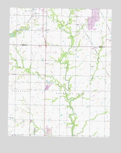
Kirkwood, KS USGS Topographic Map
Click on map above to begin viewing in our Map Viewer.

This topographic map contains these locations and features:
Feature Name Type Latitude Longitude GNIS ID View Map
AtlasPopulated PlaceN37.3673°W94.7225°484462View Map
Bird CemeteryCemeteryN37.3238°W94.7067°469600View Map
Bird School (historical)SchoolN37.3209°W94.7052°469601View Map
Brush CreekStreamN37.2970°W94.6802°469618View Map
Council CornerLocaleN37.2667°W94.7488°482700View Map
Council Corner ChurchChurchN37.2673°W94.7441°469606View Map
Council Corner School (historical)SchoolN37.2659°W94.7416°483322View Map
Council Corners CemeteryCemeteryN37.2670°W94.7436°2056967View Map
Crawford County Fire District 1 Station 1BuildingN37.3469°W94.7048°2111237View Map
Crocker CemeteryCemeteryN37.3375°W94.6717°469598View Map
East Cow CreekStreamN37.3578°W94.6841°469597View Map
Faith Lutheran ChurchChurchN37.3493°W94.7064°2688926View Map
Helmic SchoolSchoolN37.3101°W94.7422°469602View Map
Islamic Society of Southeast KansasChurchN37.3402°W94.7044°2690184View Map
KirkwoodPopulated PlaceN37.3709°W94.7225°484463View Map
KnivetonPopulated PlaceN37.3384°W94.6433°484466View Map
KramerPopulated PlaceN37.3603°W94.7300°484464View Map
LangdonPopulated PlaceN37.3531°W94.7055°484465View Map
Langdon Lane CemeteryCemeteryN37.3528°W94.7048°2739726View Map
Langdons School (historical)SchoolN37.3384°W94.7058°483281View Map
Lone Oak CemeteryCemeteryN37.3026°W94.6439°2056987View Map
Neutral School (historical)SchoolN37.2839°W94.6502°469604View Map
New Pleasant View CemeteryCemeteryN37.2518°W94.7244°2056990View Map
Old Pleasant View CemeteryCemeteryN37.2596°W94.6776°469605View Map
Owsley School (historical)SchoolN37.3189°W94.6500°482750View Map
Pleasant View (historical)LocaleN37.2806°W94.6780°481975View Map
Pleasant View ChurchChurchN37.2520°W94.7250°469603View Map
Pleasant View School (historical)SchoolN37.2667°W94.6844°483359View Map
Stillwell School (historical)SchoolN37.3598°W94.6683°469599View Map
Taylor BranchStreamN37.2876°W94.6702°469607View Map
Township of BakerCivilN37.3583°W94.6978°469616View Map
Township of Pleasant ViewCivilN37.2730°W94.6706°469334View Map
Union School (historical)SchoolN37.2878°W94.7050°483370View Map

Note: Coordinates in the location and feature list above are referenced to NAD83 datum.


Copyright (C) 2008-2024 Ryan Niemi / Sunset Dynamics ... All Rights Reserved