TopoQuest Logo
Do you find TopoQuest useful?
Help keep TopoQuest running and adding new maps/features by donating!
Bitcoin:  19c7KJd3qBynnjoSw5npx9KScwjBe4ifkT
Litecoin:  LXs6TkuXGGXo1vDsWCkWVdjQX94eUKd6ui
Home View Maps Find Maps Find Places Resources & Links


Carl Junction, Missouri Topographic Map

USGS Map Title: Carl Junction, MO
USGS Map MRC: 37094B5
DRG (GeoTIFF) Download: o37094b5.tif


Neighboring USGS Topographic Map Quads:


  Kirkwood, KS  
37094C6
 

  Asbury, MO  
37094C5
 

  Neck City, MO  
37094C4
 

  Crestline, KS  
37094B6
 

  Carl Junction, MO  
37094B5
 

  Webb City, MO  
37094B4
 

  Baxter Springs, KS  
37094A6
 

  Joplin West, MO  
37094A5
 

  Joplin East, MO  
37094A4


Map MRC Location:

N38°
W95°
N38°
W94°
H8 H7 H6 H5 H4 H3 H2 H1
G8 G7 G6 G5 G4 G3 G2 G1
F8 F7 F6 F5 F4 F3 F2 F1
E8 E7 E6 E5 E4 E3 E2 E1
D8 D7 D6 D5 D4 D3 D2 D1
C8 C7 C6 C5 C4 C3 C2 C1
B8 B7 B6 B5 B4 B3 B2 B1
A8 A7 A6 A5 A4 A3 A2 A1
N37°
W95°
N37°
W94°

Carl Junction, MO USGS 1:24K Topographic Map Preview:
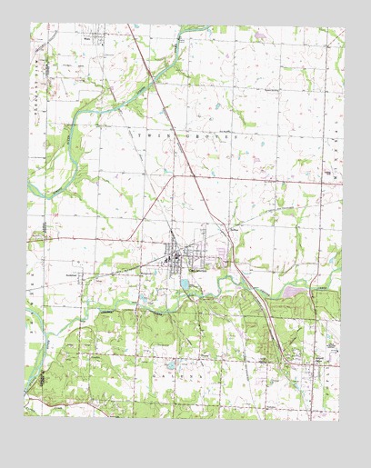
Carl Junction, MO USGS Topographic Map
Click on map above to begin viewing in our Map Viewer.

This topographic map contains these locations and features:
Feature Name Type Latitude Longitude GNIS ID View Map
Airport DrivePopulated PlaceN37.1426°W94.5108°713176View Map
Brick School (historical)SchoolN37.1434°W94.5294°714686View Map
Burton School (historical)SchoolN37.2117°W94.5961°746080View Map
Carl JunctionPopulated PlaceN37.1767°W94.5655°715396View Map
Carl Junction CemeteryCemeteryN37.1843°W94.5553°2702339View Map
Carl Junction Fire Protection District Station 1BuildingN37.1772°W94.5636°2620952View Map
Carl Junction Fire Protection District Station 3BuildingN37.2468°W94.5840°2620500View Map
Carl Junction Fire Protection District Station 4BuildingN37.1439°W94.5394°2620499View Map
Carl Junction High SchoolSchoolN37.1796°W94.5751°2709609View Map
Carl Junction Intermediate SchoolSchoolN37.1755°W94.5696°2709611View Map
Carl Junction Junior High SchoolSchoolN37.1741°W94.5698°2709610View Map
Carl Junction Police DepartmentBuildingN37.1787°W94.5658°2752173View Map
Carl Junction Post OfficePost OfficeN37.1760°W94.5647°2779448View Map
Carl Junction Primary 2 - 3 SchoolSchoolN37.1762°W94.5685°2709612View Map
Carl Junction Primary K - 1 SchoolSchoolN37.1744°W94.5686°2709613View Map
Center CreekStreamN37.1512°W94.6169°715636View Map
Center School (historical)SchoolN37.2376°W94.5150°746082View Map
City of Carl JunctionCivilN37.1669°W94.5467°2393742View Map
City of WacoCivilN37.2470°W94.6003°2397158View Map
Cook AirportAirportN37.1862°W94.5523°2679307View Map
Elliot LakeReservoirN37.2470°W94.5338°763099View Map
Elliot Lake DamDamN37.2467°W94.5352°763098View Map
GulftonPopulated PlaceN37.1837°W94.5450°718919View Map
Howard CemeteryCemeteryN37.1742°W94.5541°719909View Map
Joplin Regional AirportAirportN37.1479°W94.5007°758741View Map
JTA Asbell FieldAirportN37.1891°W94.5475°2679308View Map
KIXQ-FM (Webb City)TowerN37.2428°W94.5061°759064View Map
KlondikePopulated PlaceN37.1451°W94.5994°720661View Map
Mound CemeteryCemeteryN37.1819°W94.6189°469333View Map
New Hope ChurchChurchN37.2162°W94.5450°723246View Map
Oscie Ora Acres LakeReservoirN37.1659°W94.5193°763190View Map
Oscie Ora Acres Lake DamDamN37.1667°W94.5236°763189View Map
Pleasant Hill ChurchChurchN37.2295°W94.5263°724524View Map
Prairie Hill School (historical)SchoolN37.2312°W94.5536°746079View Map
Sherwood CemeteryCemeteryN37.1484°W94.5733°726345View Map
SmithfieldPopulated PlaceN37.1689°W94.6030°726637View Map
Smithfield School (historical)SchoolN37.1710°W94.6032°745712View Map
StringtownPopulated PlaceN37.1703°W94.5800°729972View Map
ThomsPopulated PlaceN37.1442°W94.5561°740023View Map
Township of Twin GrovesCivilN37.2096°W94.5633°766820View Map
TuckahoePopulated PlaceN37.1287°W94.5294°727823View Map
Twin Grove CemeteryCemeteryN37.2006°W94.5261°727925View Map
Twin Groves School (historical)SchoolN37.2020°W94.5394°746133View Map
Village of Airport DriveCivilN37.1405°W94.5162°2397919View Map
WacoPopulated PlaceN37.2470°W94.5994°728227View Map
Waco CemeteryCemeteryN37.2400°W94.5952°728228View Map
Waco School (historical)SchoolN37.2433°W94.5964°746078View Map
Zincite School (historical)SchoolN37.1304°W94.5994°746081View Map

Note: Coordinates in the location and feature list above are referenced to NAD83 datum.


Copyright (C) 2008-2024 Ryan Niemi / Sunset Dynamics ... All Rights Reserved