TopoQuest Logo
Do you find TopoQuest useful?
Help keep TopoQuest running and adding new maps/features by donating!
Bitcoin:  19c7KJd3qBynnjoSw5npx9KScwjBe4ifkT
Litecoin:  LXs6TkuXGGXo1vDsWCkWVdjQX94eUKd6ui
Home View Maps Find Maps Find Places Resources & Links


Dendron, Virginia Topographic Map

USGS Map Title: Dendron, VA
USGS Map MRC: 37076A8
DRG (GeoTIFF) Download: o37076a8.tif


Neighboring USGS Topographic Map Quads:


  Savedge, VA  
37077B1
 

  Claremont, VA  
37076B8
 

  Surry, VA  
37076B7
 

  Waverly, VA  
37077A1
 

  Dendron, VA  
37076A8
 

  Runnymede, VA  
37076A7
 

  Manry, VA  
36077H1
 

  Ivor, VA  
36076H8
 

  Raynor, VA  
36076H7


Map MRC Location:

N38°
W77°
N38°
W76°
H8 H7 H6 H5 H4 H3 H2 H1
G8 G7 G6 G5 G4 G3 G2 G1
F8 F7 F6 F5 F4 F3 F2 F1
E8 E7 E6 E5 E4 E3 E2 E1
D8 D7 D6 D5 D4 D3 D2 D1
C8 C7 C6 C5 C4 C3 C2 C1
B8 B7 B6 B5 B4 B3 B2 B1
A8 A7 A6 A5 A4 A3 A2 A1
N37°
W77°
N37°
W76°

Dendron, VA USGS 1:24K Topographic Map Preview:
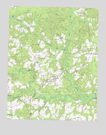
Dendron, VA USGS Topographic Map
Click on map above to begin viewing in our Map Viewer.

This topographic map contains these locations and features:
Feature Name Type Latitude Longitude GNIS ID View Map
Atkins DamDamN37.1113°W76.9925°1490918View Map
Atkins PondReservoirN37.1121°W76.9943°1501936View Map
Birchen Island Bridge (historical)BridgeN37.0260°W76.9622°1740122View Map
Birdsongs Mill (historical)LocaleN37.0274°W76.9983°1690179View Map
Carsley DistrictCivilN37.1152°W76.9999°1927127View Map
Cedar Grove School (historical)SchoolN37.0657°W76.9719°1740127View Map
Coppahaunk SwampStreamN37.0368°W76.9683°1465231View Map
County AcademySchoolN37.0482°W76.9339°1465296View Map
Cypress SwampStreamN37.0263°W76.8905°1465566View Map
Dark SwampStreamN37.1129°W76.9133°1465617View Map
DendronPopulated PlaceN37.0454°W76.9361°1492862View Map
Dendron DistrictCivilN37.0281°W76.8916°1927174View Map
Dendron Post OfficePost OfficeN37.0453°W76.9347°2519606View Map
Dendron Volunteer Fire Department Surry County Station 2BuildingN37.0491°W76.9277°2085894View Map
ElberonPopulated PlaceN37.0743°W76.8836°1477294View Map
Ellis ForkPopulated PlaceN37.0032°W76.9005°1477302View Map
Elwood SwampStreamN37.0818°W76.9177°1466270View Map
Goodrich ForkPopulated PlaceN37.0004°W76.9175°1477362View Map
Harrison Grove ChurchChurchN37.0785°W76.8816°1467790View Map
Hazel SwampStreamN37.0738°W76.9147°1467879View Map
Hazelbush School (historical)SchoolN37.0588°W76.9047°1740136View Map
Johnchecohunk SwampStreamN37.0743°W76.9164°1468765View Map
Lazy Oak CornerPopulated PlaceN37.1185°W76.8952°1477480View Map
Luther P Jackson Middle SchoolSchoolN37.0833°W76.9034°1468610View Map
Milltail CreekStreamN37.0213°W76.9438°1470589View Map
New BridgeBridgeN37.0499°W76.9927°1690233View Map
New Lebannon ChurchChurchN37.0746°W76.8830°1471460View Map
Newby Run ChurchChurchN37.0638°W76.9586°1471512View Map
Newby Run School (historical)SchoolN37.0632°W76.9594°1740143View Map
Oak Grove ChurchChurchN37.0027°W76.9288°1471712View Map
Pigeonroost SwampStreamN37.1088°W76.8880°1472295View Map
Rocky BranchStreamN37.0249°W76.9861°1473425View Map
Rough School (historical)SchoolN37.0888°W76.9936°1740151View Map
Saint Marys ChurchChurchN37.0365°W76.9530°1473828View Map
Salisbury School (historical)SchoolN37.1074°W76.9744°1740154View Map
Sexton (historical)Populated PlaceN37.0529°W76.9233°1740155View Map
Spratleys MillPopulated PlaceN37.0774°W76.9247°1493637View Map
Spring Hill ChurchChurchN37.0293°W76.9969°1475001View Map
Spring Hill DamDamN37.0271°W76.9986°1490929View Map
Surry CountyCivilN37.1169°W76.8883°1480174View Map
Surry County High SchoolSchoolN37.0803°W76.9040°1740156View Map
Surry Elementary SchoolSchoolN37.0793°W76.9015°2465158View Map
Surry Lookout TowerTowerN37.0804°W76.8802°1491277View Map
Town of DendronCivilN37.0364°W76.9241°2390145View Map
Union ChurchChurchN37.0913°W76.9252°1476043View Map

Note: Coordinates in the location and feature list above are referenced to NAD83 datum.


Copyright (C) 2008-2024 Ryan Niemi / Sunset Dynamics ... All Rights Reserved