TopoQuest Logo
Do you find TopoQuest useful?
Help keep TopoQuest running and adding new maps/features by donating!
Bitcoin:  19c7KJd3qBynnjoSw5npx9KScwjBe4ifkT
Litecoin:  LXs6TkuXGGXo1vDsWCkWVdjQX94eUKd6ui
Home View Maps Find Maps Find Places Resources & Links


Claremont, Virginia Topographic Map

USGS Map Title: Claremont, VA
USGS Map MRC: 37076B8
DRG (GeoTIFF) Download: o37076b8.tif


Neighboring USGS Topographic Map Quads:


  Charles City, VA  
37077C1
 

  Brandon, VA  
37076C8
 

  Norge, VA  
37076C7
 

  Savedge, VA  
37077B1
 

  Claremont, VA  
37076B8
 

  Surry, VA  
37076B7
 

  Waverly, VA  
37077A1
 

  Dendron, VA  
37076A8
 

  Runnymede, VA  
37076A7


Map MRC Location:

N38°
W77°
N38°
W76°
H8 H7 H6 H5 H4 H3 H2 H1
G8 G7 G6 G5 G4 G3 G2 G1
F8 F7 F6 F5 F4 F3 F2 F1
E8 E7 E6 E5 E4 E3 E2 E1
D8 D7 D6 D5 D4 D3 D2 D1
C8 C7 C6 C5 C4 C3 C2 C1
B8 B7 B6 B5 B4 B3 B2 B1
A8 A7 A6 A5 A4 A3 A2 A1
N37°
W77°
N37°
W76°

Claremont, VA USGS 1:24K Topographic Map Preview:
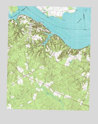
Claremont, VA USGS Topographic Map
Click on map above to begin viewing in our Map Viewer.

This topographic map contains these locations and features:
Feature Name Type Latitude Longitude GNIS ID View Map
Brandon GutStreamN37.2326°W76.9886°1463761View Map
Burdocks Wharf (historical)LocaleN37.2393°W76.9752°1740124View Map
Camp LionsLocaleN37.1982°W76.8825°1464340View Map
Chickahominy RiverStreamN37.2335°W76.8897°1478374View Map
Chippokes PointCapeN37.2449°W76.9858°1464868View Map
ClaremontPopulated PlaceN37.2279°W76.9641°1464932View Map
Claremont DistrictCivilN37.1833°W76.9289°1927149View Map
Claremont ManorPopulated PlaceN37.2365°W76.9775°1492772View Map
Claremont PointCapeN37.2388°W76.9714°1740131View Map
Claremont Post OfficePost OfficeN37.2246°W76.9657°2519600View Map
Claremont Public LibraryBuildingN37.2277°W76.9650°2519903View Map
Claremont Volunteer Fire Department Station 1BuildingN37.1861°W76.9691°2085895View Map
Claremont Volunteer Fire Department Station 2BuildingN37.2264°W76.9657°2660568View Map
Claremont WharfLocaleN37.2321°W76.9552°1478079View Map
Claremont-Sandy Point Ferry (historical)CrossingN37.2343°W76.9477°1740132View Map
Dancing PointCapeN37.2335°W76.9164°1478465View Map
Dancing Point Shoal Channel RangeLocaleN37.2118°W76.9219°1478076View Map
During PointCapeN37.2454°W76.8975°1478517View Map
EastoverPopulated PlaceN37.1982°W76.8927°1492896View Map
Eastover DamDamN37.1851°W76.9030°1490919View Map
Eastover PondReservoirN37.1837°W76.9041°1490920View Map
Educational FoundationSchoolN37.2265°W76.9664°1466183View Map
Ferry PointCapeN37.2415°W76.9475°1739763View Map
Guilford HeightsPopulated PlaceN37.2088°W76.9186°1478077View Map
Mercy Seat ChurchChurchN37.1376°W76.8827°1470363View Map
Old Dominion School (historical)SchoolN37.1490°W76.9294°1740147View Map
Pipsico Boy Scout ReservationLocaleN37.1932°W76.8811°1472439View Map
Saint Anne's CemeteryCemeteryN37.2318°W76.9630°1740153View Map
Sandy PointCapeN37.2374°W76.9400°1479547View Map
Sandy Point WharfLocaleN37.2343°W76.9480°1478080View Map
Sloop PointCapeN37.2310°W76.9489°1474700View Map
Spring GrovePopulated PlaceN37.1657°W76.9733°1477778View Map
Spring Grove Post OfficePost OfficeN37.1659°W76.9732°2519653View Map
Spring Grove SwampStreamN37.1549°W76.9527°1474997View Map
Sunken Meadow BeachPopulated PlaceN37.2188°W76.9347°1478075View Map
Sunken Meadow CreekStreamN37.2199°W76.9330°1475331View Map
Sunken Meadow DamDamN37.2182°W76.9341°1490912View Map
Sunken Meadow PondReservoirN37.2116°W76.9395°1490913View Map
Swanns Point ChurchChurchN37.1701°W76.9622°1475370View Map
Telluride School (historical)SchoolN37.2343°W76.9652°1740162View Map
TettingtonPopulated PlaceN37.2415°W76.9466°1479715View Map
Tomahund CreekStreamN37.2493°W76.8975°1479746View Map
Town of ClaremontCivilN37.2273°W76.9665°2390796View Map
Upper Chippokes CreekStreamN37.2435°W76.9808°1476107View Map
WakefieldPopulated PlaceN37.2226°W76.9414°1493749View Map
WARO-AM (Claremont)TowerN37.2485°W76.9169°1502439View Map

Note: Coordinates in the location and feature list above are referenced to NAD83 datum.


Copyright (C) 2008-2024 Ryan Niemi / Sunset Dynamics ... All Rights Reserved