TopoQuest Logo
Do you find TopoQuest useful?
Help keep TopoQuest running and adding new maps/features by donating!
Bitcoin:  19c7KJd3qBynnjoSw5npx9KScwjBe4ifkT
Litecoin:  LXs6TkuXGGXo1vDsWCkWVdjQX94eUKd6ui
Home View Maps Find Maps Find Places Resources & Links


Surry, Virginia Topographic Map

USGS Map Title: Surry, VA
USGS Map MRC: 37076B7
DRG (GeoTIFF) Download: o37076b7.tif


Neighboring USGS Topographic Map Quads:


  Brandon, VA  
37076C8
 

  Norge, VA  
37076C7
 

  Williamsburg, VA  
37076C6
 

  Claremont, VA  
37076B8
 

  Surry, VA  
37076B7
 

  Hog Island, VA  
37076B6
 

  Dendron, VA  
37076A8
 

  Runnymede, VA  
37076A7
 

  Bacons Castle, VA  
37076A6


Map MRC Location:

N38°
W77°
N38°
W76°
H8 H7 H6 H5 H4 H3 H2 H1
G8 G7 G6 G5 G4 G3 G2 G1
F8 F7 F6 F5 F4 F3 F2 F1
E8 E7 E6 E5 E4 E3 E2 E1
D8 D7 D6 D5 D4 D3 D2 D1
C8 C7 C6 C5 C4 C3 C2 C1
B8 B7 B6 B5 B4 B3 B2 B1
A8 A7 A6 A5 A4 A3 A2 A1
N37°
W77°
N37°
W76°

Surry, VA USGS 1:24K Topographic Map Preview:
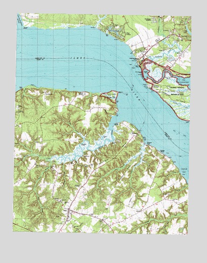
Surry, VA USGS Topographic Map
Click on map above to begin viewing in our Map Viewer.

This topographic map contains these locations and features:
Feature Name Type Latitude Longitude GNIS ID View Map
AlliancePopulated PlaceN37.1382°W76.7836°1477068View Map
ArchaeariumBuildingN37.2103°W76.7803°2129196View Map
Back RiverGutN37.2140°W76.7700°1478124View Map
Back River MarshSwampN37.2139°W76.7638°1478126View Map
Barrets PointCapeN37.2424°W76.8700°1478150View Map
Berkeley DistrictCivilN37.2308°W76.7947°1927091View Map
Berkeleys GreenPopulated PlaceN37.2489°W76.8028°2093114View Map
Black Duck GutLakeN37.2026°W76.8069°1463482View Map
Blizzards CornersPopulated PlaceN37.1454°W76.7666°1740123View Map
Broad SwampSwampN37.2022°W76.8640°1463858View Map
Camp ChancoLocaleN37.1810°W76.7838°1464361View Map
Camp KiwanisLocaleN37.1965°W76.8727°1464339View Map
Cedar Field CreekStreamN37.1604°W76.7561°1464607View Map
Church PointCapeN37.2110°W76.7800°1478389View Map
Clara Byrd Baker Elementary SchoolSchoolN37.2486°W76.7659°1779401View Map
Clarks LandingLocaleN37.1668°W76.8458°1499267View Map
Cobham WharfLocaleN37.1718°W76.7702°1465035View Map
Cross CreekStreamN37.1779°W76.8250°1465477View Map
Cross Creek LandingLocaleN37.1763°W76.8269°1499307View Map
Crouch CreekStreamN37.1771°W76.7819°1465485View Map
Dark SwampStreamN37.1660°W76.8489°1465618View Map
Davis LandingLocaleN37.1640°W76.8347°1499326View Map
Dillard WharfLocaleN37.2074°W76.8689°1477910View Map
Dollers PointCapeN37.1668°W76.7663°1477048View Map
Earl Hall Mobile Home ParkPopulated PlaceN37.1318°W76.8103°2519693View Map
First ColonyPopulated PlaceN37.2385°W76.8025°1499412View Map
First Settlers CampgroundLocaleN37.2306°W76.7683°2092556View Map
Fort James (historical)MilitaryN37.2089°W76.7789°2129195View Map
Four Mile TreeLocaleN37.2046°W76.8527°1466808View Map
Four-H CampLocaleN37.2285°W76.7908°1478620View Map
Fox IslandIslandN37.2001°W76.7608°1848396View Map
Gate House FarmsPopulated PlaceN37.2286°W76.7550°2092554View Map
Glass HouseBuildingN37.2207°W76.7852°1779405View Map
Glass House PointCapeN37.2171°W76.7841°1478661View Map
Grace Union ChurchChurchN37.1279°W76.8313°1467328View Map
Grays CreekStreamN37.1915°W76.8000°1467411View Map
Grays Creek MarinaLocaleN37.1774°W76.8058°1491158View Map
Grays LandingLocaleN37.1704°W76.8252°1499491View Map
Haystack GutGutN37.1932°W76.8083°1467869View Map
Hulls Slash GutGutN37.1576°W76.8386°1468373View Map
Indian Village CampgroundLocaleN37.2406°W76.7647°2092553View Map
Ingersoll (historical)Populated PlaceN37.1968°W76.8152°1740137View Map
JamestownPopulated PlaceN37.2082°W76.7741°1499605View Map
Jamestown Beach CampgroundLocaleN37.2303°W76.7850°2092558View Map
Jamestown Festival ParkParkN37.2243°W76.7877°1478841View Map
Jamestown IslandIslandN37.2035°W76.7588°1478842View Map
Jamestown Post OfficePost OfficeN37.2113°W76.7774°1498900View Map
Jamestown Yacht BasinHarborN37.2256°W76.7786°2092557View Map
Jamestown Yacht BasinHarborN37.2260°W76.7785°2520107View Map
Jamestown-Scotland Wharf FerryCrossingN37.2050°W76.7858°2092551View Map
Kingsmill CreekStreamN37.2093°W76.7513°1478897View Map
Lake PasbeheghReservoirN37.2408°W76.8050°1502093View Map
Lake Pasbehegh DamDamN37.2407°W76.8088°1490143View Map
LakewoodPopulated PlaceN37.2374°W76.7508°1499640View Map
Lebanon ChurchChurchN37.1435°W76.8425°1469244View Map
Lebanon SchoolSchoolN37.1429°W76.8408°1469254View Map
Melville AirstripAirportN37.1460°W76.7897°1498823View Map
Mill Farm RunStreamN37.1335°W76.7630°1470522View Map
Morris Grove ChurchChurchN37.1560°W76.8219°1470760View Map
Mother GutGutN37.1790°W76.8116°1470789View Map
Mount PleasantPopulated PlaceN37.2046°W76.8250°1499777View Map
Newtown (historical)Populated PlaceN37.1346°W76.8183°1740144View Map
Oakwood CemeteryCemeteryN37.1418°W76.8391°1471796View Map
Old Courthouse CornersLocaleN37.1635°W76.8589°1471837View Map
Orchard RunStreamN37.2043°W76.7719°1848402View Map
Passmore CreekLakeN37.1990°W76.7523°1479298View Map
Peach Orchard GutLakeN37.1634°W76.8230°1472147View Map
Pitch and Tar SwampSwampN37.2071°W76.7663°1479335View Map
Pleasant PointPopulated PlaceN37.1754°W76.7805°1499884View Map
Poplar Lawn CemeteryCemeteryN37.1446°W76.7613°1472654View Map
Poplar Lawn ChurchChurchN37.1476°W76.7666°1472656View Map
Powhatan CreekStreamN37.2146°W76.7830°1479375View Map
Powhatan ShoresPopulated PlaceN37.2253°W76.7647°2092555View Map
Pyping PointCapeN37.2182°W76.7672°1479389View Map
Saint Georges HundredPopulated PlaceN37.2474°W76.7769°1779430View Map
Sandy BayLakeN37.2168°W76.7818°1479544View Map
ScotlandPopulated PlaceN37.1838°W76.7863°1500040View Map
Scotland Census Designated PlaceCensusN37.1811°W76.7965°2629038View Map
Scotland NeckCapeN37.1701°W76.8033°1474105View Map
Smith FortLocaleN37.1699°W76.8238°1474749View Map
Spring RunStreamN37.1690°W76.8616°1475013View Map
SurryPopulated PlaceN37.1379°W76.8352°1500197View Map
Surry County CourthouseBuildingN37.1385°W76.8352°1740158View Map
Surry County Sheriff's OfficeBuildingN37.1338°W76.8342°2085897View Map
Surry County Sheriff's OfficeBuildingN37.1341°W76.8345°2331973View Map
Surry DistrictCivilN37.1678°W76.7811°1927533View Map
Surry Post OfficePost OfficeN37.1380°W76.8334°2519655View Map
Surry Public LibraryBuildingN37.1331°W76.8364°2520477View Map
Surry Volunteer Fire DepartmentBuildingN37.1324°W76.8345°2085893View Map
Surry Volunteer Rescue SquadBuildingN37.1331°W76.8363°2331855View Map
Surry Volunteer Rescue SquadBuildingN37.1328°W76.8363°2085896View Map
Swanns PointCapeN37.2057°W76.8011°1477935View Map
Swanns Point PlantationLocaleN37.1971°W76.8191°1740160View Map
Swanns Point Plantation CemeteryCemeteryN37.2008°W76.8181°1740161View Map
Tandem Health Care of Williamsburg Nursing HomeBuildingN37.2409°W76.7659°2520053View Map
The Church of Jesus ChristChurchN37.1526°W76.8272°1475564View Map
Timber NeckCapeN37.1599°W76.7950°1475721View Map
Timber Neck CreekStreamN37.1715°W76.7836°1475723View Map
Town of SurryCivilN37.1371°W76.8333°2391434View Map
Two Rivers Country ClubLocaleN37.2475°W76.8481°2520203View Map
Warren HouseBuildingN37.1640°W76.8202°1476345View Map
Wier Neck CemeteryCemeteryN37.1615°W76.8477°1476707View Map

Note: Coordinates in the location and feature list above are referenced to NAD83 datum.


Copyright (C) 2008-2024 Ryan Niemi / Sunset Dynamics ... All Rights Reserved