TopoQuest Logo
Do you find TopoQuest useful?
Help keep TopoQuest running and adding new maps/features by donating!
Bitcoin:  19c7KJd3qBynnjoSw5npx9KScwjBe4ifkT
Litecoin:  LXs6TkuXGGXo1vDsWCkWVdjQX94eUKd6ui
Home View Maps Find Maps Find Places Resources & Links


Diamond Bluff West, Wisconsin Topographic Map

USGS Map Title: Diamond Bluff West, WI
USGS Map MRC: 44092F6
DRG (GeoTIFF) Download: o44092f6.tif


Neighboring USGS Topographic Map Quads:


  Prescott, WI  
44092G7
 

  River Falls West, WI  
44092G6
 

  River Falls East, WI  
44092G5
 

  Hastings, MN  
44092F7
 

  Diamond Bluff West, WI  
44092F6
 

  Diamond Bluff East, WI  
44092F5
 

  Miesville, MN  
44092E7
 

  Welch, MN  
44092E6
 

  Red Wing, MN  
44092E5


Map MRC Location:

N45°
W93°
N45°
W92°
H8 H7 H6 H5 H4 H3 H2 H1
G8 G7 G6 G5 G4 G3 G2 G1
F8 F7 F6 F5 F4 F3 F2 F1
E8 E7 E6 E5 E4 E3 E2 E1
D8 D7 D6 D5 D4 D3 D2 D1
C8 C7 C6 C5 C4 C3 C2 C1
B8 B7 B6 B5 B4 B3 B2 B1
A8 A7 A6 A5 A4 A3 A2 A1
N44°
W93°
N44°
W92°

Diamond Bluff West, WI USGS 1:24K Topographic Map Preview:
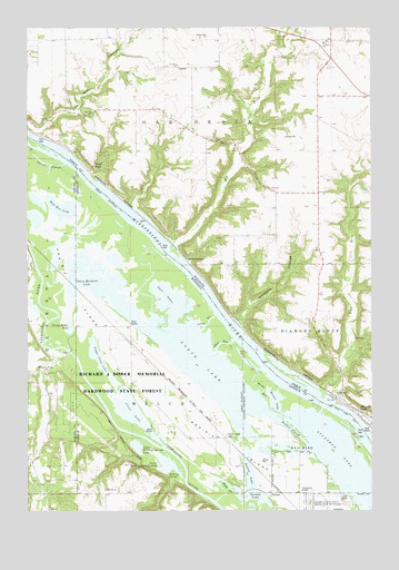
Diamond Bluff West, WI USGS Topographic Map
Click on map above to begin viewing in our Map Viewer.

This topographic map contains these locations and features:
Feature Name Type Latitude Longitude GNIS ID View Map
.20 ReservoirReservoirN44.7108°W92.6402°1793504View Map
0.22 ReservoirReservoirN44.7184°W92.6329°1793634View Map
Big RiverStreamN44.6925°W92.6985°1561758View Map
Brewer LakeLakeN44.6536°W92.6605°640467View Map
Buffalo SloughChannelN44.6461°W92.6546°640623View Map
Carter SloughLakeN44.7148°W92.7439°640942View Map
Clear LakeLakeN44.6499°W92.7113°641280View Map
Diamond BluffPopulated PlaceN44.6505°W92.6291°1563960View Map
Eagle PointCapeN44.7141°W92.7258°1564256View Map
EtterPopulated PlaceN44.6616°W92.7438°656173View Map
Etter (historical)LocaleN44.6617°W92.7436°2094734View Map
Etter Post Office (historical)Post OfficeN44.6617°W92.7436°2094733View Map
Hardy RunChannelN44.6561°W92.6646°644670View Map
Huppert E 7689 DamDamN44.7183°W92.6319°1793633View Map
Jackson RunChannelN44.6736°W92.6846°645564View Map
John G Hoikka G-9526 DamDamN44.7100°W92.6402°1793503View Map
Larson LakeLakeN44.6288°W92.6684°646499View Map
Lower Rattling Springs LakeLakeN44.6374°W92.7000°647259View Map
Messiah Episcopal ChurchChurchN44.6278°W92.6472°2064809View Map
Miley RunChannelN44.6686°W92.6794°647841View Map
Morgan CouleeValleyN44.6736°W92.6731°1569727View Map
Mud Hen LakeLakeN44.7035°W92.7383°648207View Map
Nelson LakeReservoirN44.6343°W92.6698°648464View Map
North LakeLakeN44.6629°W92.6869°648660View Map
Prairie IslandIslandN44.6491°W92.6913°649708View Map
Prairie Island CemeteryCemeteryN44.6447°W92.6777°649709View Map
Prairie Island Indian CommunityCivilN44.6477°W92.6706°654519View Map
Prairie Island Tribal Police DepartmentBuildingN44.6271°W92.6528°2758709View Map
Prairie Island-Schaller Airport (historical)AirportN44.6616°W92.7108°660371View Map
Rattling SpringsSpringN44.6339°W92.6988°649848View Map
Saint Johns ChurchChurchN44.7405°W92.6963°1573101View Map
Saint Marys SchoolSchoolN44.7461°W92.6421°1573348View Map
Sharp Muskrat LakeLakeN44.6854°W92.7263°651919View Map
Smith BarLocaleN44.6666°W92.6669°654537View Map
Smith LandingPopulated PlaceN44.6891°W92.6919°1581162View Map
Spring Banks LakeLakeN44.6729°W92.7345°652420View Map
StromsPopulated PlaceN44.6294°W92.6616°654963View Map
Sturgeon LakeLakeN44.6383°W92.6376°652749View Map
Town of Oak GroveCivilN44.7369°W92.6885°1583842View Map
Twin LakesLakeN44.6793°W92.6979°653428View Map
Upper Clear LakeLakeN44.6635°W92.7233°653541View Map
Upper Rattling Springs LakeLakeN44.6417°W92.7105°653560View Map
Wind RiverStreamN44.6536°W92.6427°1576851View Map
Wood SloughLakeN44.6316°W92.6771°654342View Map

Note: Coordinates in the location and feature list above are referenced to NAD83 datum.


Copyright (C) 2008-2024 Ryan Niemi / Sunset Dynamics ... All Rights Reserved