TopoQuest Logo
Do you find TopoQuest useful?
Help keep TopoQuest running and adding new maps/features by donating!
Bitcoin:  19c7KJd3qBynnjoSw5npx9KScwjBe4ifkT
Litecoin:  LXs6TkuXGGXo1vDsWCkWVdjQX94eUKd6ui
Home View Maps Find Maps Find Places Resources & Links


Welch, Minnesota Topographic Map

USGS Map Title: Welch, MN
USGS Map MRC: 44092E6
DRG (GeoTIFF) Download: o44092e6.tif


Neighboring USGS Topographic Map Quads:


  Hastings, MN  
44092F7
 

  Diamond Bluff West, WI  
44092F6
 

  Diamond Bluff East, WI  
44092F5
 

  Miesville, MN  
44092E7
 

  Welch, MN  
44092E6
 

  Red Wing, MN  
44092E5
 

  White Rock, MN  
44092D7
 

  Goodhue West, MN  
44092D6
 

  Goodhue East, MN  
44092D5


Map MRC Location:

N45°
W93°
N45°
W92°
H8 H7 H6 H5 H4 H3 H2 H1
G8 G7 G6 G5 G4 G3 G2 G1
F8 F7 F6 F5 F4 F3 F2 F1
E8 E7 E6 E5 E4 E3 E2 E1
D8 D7 D6 D5 D4 D3 D2 D1
C8 C7 C6 C5 C4 C3 C2 C1
B8 B7 B6 B5 B4 B3 B2 B1
A8 A7 A6 A5 A4 A3 A2 A1
N44°
W93°
N44°
W92°

Welch, MN USGS 1:24K Topographic Map Preview:
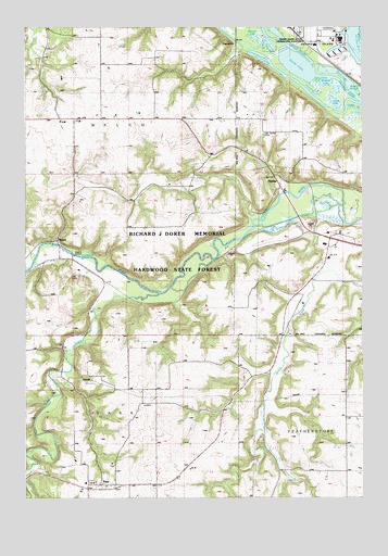
Welch, MN USGS Topographic Map
Click on map above to begin viewing in our Map Viewer.

This topographic map contains these locations and features:
Feature Name Type Latitude Longitude GNIS ID View Map
Belle CreekStreamN44.5541°W92.7005°639886View Map
Birch LakeLakeN44.6108°W92.6335°640165View Map
Brunner LakeLakeN44.6222°W92.6648°640553View Map
Burnside SchoolSchoolN44.5636°W92.6377°640668View Map
Catfish SloughStreamN44.6034°W92.6306°640977View Map
Cross of Christ ChurchChurchN44.6000°W92.7306°2064905View Map
Donald Johnson DamDamN44.5133°W92.6885°1776613View Map
EgglestonPopulated PlaceN44.6200°W92.6721°654687View Map
Eggleston Post Office (historical)Post OfficeN44.6200°W92.6719°2064883View Map
Goose LakeLakeN44.6150°W92.6492°644242View Map
HarlissPopulated PlaceN44.5825°W92.6555°654743View Map
Harold Eckblad DamDamN44.5600°W92.6302°1776607View Map
Indian SloughLakeN44.6213°W92.6546°645422View Map
Jones LakeLakeN44.6050°W92.6350°645727View Map
Messiah Episcopal CemeteryCemeteryN44.5428°W92.6483°2065071View Map
Mount Carmel CemeteryCemeteryN44.5966°W92.6616°648165View Map
Swedish Methodist Episcopal CemeteryCemeteryN44.5031°W92.7115°2065009View Map
Township of VasaCivilN44.5072°W92.7293°665852View Map
Township of WelchCivilN44.6141°W92.7261°665947View Map
VasaPopulated PlaceN44.5033°W92.7224°653622View Map
Vasa CemeteryCemeteryN44.5040°W92.7257°2065010View Map
Vasa Evangelical Lutheran ChurchChurchN44.5033°W92.7208°2064902View Map
Vasa MuseumBuildingN44.5033°W92.7222°2065032View Map
Vasa MuseumBuildingN44.5033°W92.7208°2064903View Map
Vasa Post Office (historical)Post OfficeN44.5033°W92.7222°2064861View Map
Vasa: Mattson's Settlement Historical MarkerParkN44.5033°W92.7222°2065033View Map
Vermillion RiverStreamN44.6205°W92.6669°653634View Map
WelchPopulated PlaceN44.5683°W92.7385°653897View Map
Welch (historical)LocaleN44.5639°W92.7369°2064900View Map
Welch CemeteryCemeteryN44.6000°W92.7305°2065019View Map
Welch ChurchChurchN44.6000°W92.7296°653898View Map
Welch DamDamN44.5683°W92.7402°1777174View Map
Welch Post OfficePost OfficeN44.5685°W92.7386°2064904View Map
Welch Village Ski AreaLocaleN44.5606°W92.7272°2064901View Map
Wildcat LakeLakeN44.6103°W92.6385°654140View Map

Note: Coordinates in the location and feature list above are referenced to NAD83 datum.


Copyright (C) 2008-2024 Ryan Niemi / Sunset Dynamics ... All Rights Reserved