TopoQuest Logo
Do you find TopoQuest useful?
Help keep TopoQuest running and adding new maps/features by donating!
Bitcoin:  19c7KJd3qBynnjoSw5npx9KScwjBe4ifkT
Litecoin:  LXs6TkuXGGXo1vDsWCkWVdjQX94eUKd6ui
Home View Maps Find Maps Find Places Resources & Links


Dibrell, Tennessee Topographic Map

USGS Map Title: Dibrell, TN
USGS Map MRC: 35085G7
DRG (GeoTIFF) Download: o35085g7.tif


Neighboring USGS Topographic Map Quads:


  Gassaway, TN  
35085H8
 

  Smithville, TN  
35085H7
 

  Sligo Bridge, TN  
35085H6
 

  Short Mountain, TN  
35085G8
 

  Dibrell, TN  
35085G7
 

  Campaign, TN  
35085G6
 

  Centertown, TN  
35085F8
 

  McMinnville, TN  
35085F7
 

  Cardwell Mountain, TN  
35085F6


Map MRC Location:

N36°
W86°
N36°
W85°
H8 H7 H6 H5 H4 H3 H2 H1
G8 G7 G6 G5 G4 G3 G2 G1
F8 F7 F6 F5 F4 F3 F2 F1
E8 E7 E6 E5 E4 E3 E2 E1
D8 D7 D6 D5 D4 D3 D2 D1
C8 C7 C6 C5 C4 C3 C2 C1
B8 B7 B6 B5 B4 B3 B2 B1
A8 A7 A6 A5 A4 A3 A2 A1
N35°
W86°
N35°
W85°

Dibrell, TN USGS 1:24K Topographic Map Preview:
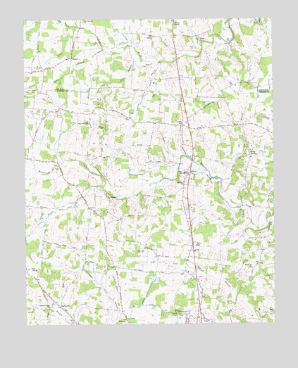
Dibrell, TN USGS Topographic Map
Click on map above to begin viewing in our Map Viewer.

This topographic map contains these locations and features:
Feature Name Type Latitude Longitude GNIS ID View Map
Allen CemeteryCemeteryN35.8589°W85.7986°1313831View Map
Bear Branch (historical)Populated PlaceN35.8570°W85.7980°1314052View Map
BethelPopulated PlaceN35.8584°W85.8508°1314669View Map
Bethel United Methodist ChurchChurchN35.8592°W85.8508°1322514View Map
Blue Springs SchoolSchoolN35.8742°W85.8447°1313859View Map
Bluff SpringsPopulated PlaceN35.8187°W85.7619°1314707View Map
Bluff Springs BranchStreamN35.8087°W85.7761°1277836View Map
Bluff Springs Church of ChristChurchN35.8176°W85.7644°1646733View Map
Bluff Springs School (historical)SchoolN35.8312°W85.7666°1320516View Map
Bratcher CemeteryCemeteryN35.8747°W85.8458°2711397View Map
Cantrell CemeteryCemeteryN35.8608°W85.7550°2711402View Map
Charles Creek ChurchChurchN35.7570°W85.8633°1280273View Map
Circle J Tree FarmLocaleN35.8158°W85.8153°2662627View Map
Clear Springs BranchStreamN35.8573°W85.8080°1313889View Map
Commissioner District 12CivilN35.7870°W85.8532°2464366View Map
Commissioner District 6CivilN35.8724°W85.7658°2464525View Map
Cumberland School (historical)SchoolN35.7978°W85.8425°1320528View Map
Dekalb County Fire Department Station 69BuildingN35.8582°W85.8510°2654936View Map
Devenport CreekStreamN35.7601°W85.8314°1652474View Map
DibrellPopulated PlaceN35.8120°W85.7919°1282420View Map
Dibrell Division (historical)CensusN35.7892°W85.7917°1648997View Map
Dibrell Elementary SchoolSchoolN35.8117°W85.7950°1320532View Map
Dry BranchStreamN35.8723°W85.8522°1313916View Map
EarleyvillePopulated PlaceN35.7576°W85.8578°1314994View Map
Earleyville Church of ChristChurchN35.7553°W85.8542°1320534View Map
Evanston (historical)Populated PlaceN35.8181°W85.8736°1645045View Map
Ferrell CemeteryCemeteryN35.8641°W85.8101°2711669View Map
Fuston CemeteryCemeteryN35.7709°W85.7983°1285054View Map
GathPopulated PlaceN35.7801°W85.7908°1315102View Map
Gath Baptist ChurchChurchN35.7803°W85.7914°1320540View Map
Gath BranchStreamN35.7903°W85.7600°1285241View Map
Green HillPopulated PlaceN35.8317°W85.7955°1315151View Map
Griffith CemeteryCemeteryN35.8563°W85.8185°2711720View Map
Griffith CemeteryCemeteryN35.8576°W85.8230°2711739View Map
Griffith CemeteryCemeteryN35.8576°W85.8230°1313943View Map
Highland ChurchChurchN35.7731°W85.7614°1287745View Map
Highland School (historical)SchoolN35.7731°W85.7608°1320546View Map
Holders CemeteryCemeteryN35.8156°W85.8583°1288036View Map
Jones BranchStreamN35.8628°W85.8350°1313978View Map
Jones Mill (historical)LocaleN35.8690°W85.8494°1322577View Map
Kirby CemeteryCemeteryN35.7509°W85.8503°1290281View Map
Long Hollow BranchStreamN35.8067°W85.8394°1291976View Map
LuckyPopulated PlaceN35.7976°W85.8428°1315446View Map
Magnum (historical)Populated PlaceN35.8370°W85.8583°1311881View Map
Martin CemeteryCemeteryN35.8634°W85.7889°1313994View Map
Mizer SwampSwampN35.7655°W85.8105°1647547View Map
Mount Zion ChurchChurchN35.8073°W85.7947°1306798View Map
Mountain View School (historical)SchoolN35.7573°W85.8711°1320562View Map
New Bildad Primitive Baptist ChurchChurchN35.8665°W85.7867°1313854View Map
New Bildad Primitive Baptist Church CemeteryCemeteryN35.8666°W85.7867°2710642View Map
North Oak Grove ChurchChurchN35.8326°W85.8425°1306841View Map
North Warren Volunteer Fire Department Station 1BuildingN35.8108°W85.7915°2654534View Map
Oak Grove School (historical)SchoolN35.8315°W85.8417°1320566View Map
Oaks SchoolSchoolN35.7728°W85.8694°1296203View Map
Providence ChurchChurchN35.8012°W85.8328°1298605View Map
Salem ChurchChurchN35.7540°W85.7508°1300556View Map
Ward CemeteryCemeteryN35.8685°W85.8554°2712363View Map
Warren County BranchStreamN35.8576°W85.8072°1313811View Map
Webb CemeteryCemeteryN35.8176°W85.7655°1274017View Map
Webbs ChapelChurchN35.8728°W85.7992°1313813View Map
WomackPopulated PlaceN35.7517°W85.8247°1314531View Map
Womacks Mill (historical)LocaleN35.8106°W85.7816°1320587View Map

Note: Coordinates in the location and feature list above are referenced to NAD83 datum.


Copyright (C) 2008-2024 Ryan Niemi / Sunset Dynamics ... All Rights Reserved