TopoQuest Logo
Do you find TopoQuest useful?
Help keep TopoQuest running and adding new maps/features by donating!
Bitcoin:  19c7KJd3qBynnjoSw5npx9KScwjBe4ifkT
Litecoin:  LXs6TkuXGGXo1vDsWCkWVdjQX94eUKd6ui
Home View Maps Find Maps Find Places Resources & Links


Gassaway, Tennessee Topographic Map

USGS Map Title: Gassaway, TN
USGS Map MRC: 35085H8
DRG (GeoTIFF) Download: o35085h8.tif


Neighboring USGS Topographic Map Quads:


  Alexandria, TN  
36086A1
 

  Liberty, TN  
36085A8
 

  Center Hill Dam, TN  
36085A7
 

  Auburntown, TN  
35086H1
 

  Gassaway, TN  
35085H8
 

  Smithville, TN  
35085H7
 

  Woodbury, TN  
35086G1
 

  Short Mountain, TN  
35085G8
 

  Dibrell, TN  
35085G7


Map MRC Location:

N36°
W86°
N36°
W85°
H8 H7 H6 H5 H4 H3 H2 H1
G8 G7 G6 G5 G4 G3 G2 G1
F8 F7 F6 F5 F4 F3 F2 F1
E8 E7 E6 E5 E4 E3 E2 E1
D8 D7 D6 D5 D4 D3 D2 D1
C8 C7 C6 C5 C4 C3 C2 C1
B8 B7 B6 B5 B4 B3 B2 B1
A8 A7 A6 A5 A4 A3 A2 A1
N35°
W86°
N35°
W85°

Gassaway, TN USGS 1:24K Topographic Map Preview:
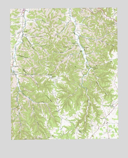
Gassaway, TN USGS Topographic Map
Click on map above to begin viewing in our Map Viewer.

This topographic map contains these locations and features:
Feature Name Type Latitude Longitude GNIS ID View Map
Adamson BranchStreamN35.9745°W85.9847°1313825View Map
Adamson CemeteryCemeteryN35.9455°W85.9575°2711203View Map
Anderson HollowValleyN35.9925°W85.9839°1313837View Map
Barnes CemeteryCemeteryN35.9762°W85.9179°2710640View Map
Beech Hill CemeteryCemeteryN35.9381°W85.9967°1276842View Map
Bennett CemeteryCemeteryN35.9766°W85.9010°2711377View Map
Big HollowValleyN35.9275°W85.9170°1313851View Map
Blair CemeteryCemeteryN35.8881°W85.9040°2711380View Map
Blue SpringSpringN35.9778°W85.9847°1313857View Map
Bluhm CemeteryCemeteryN35.9068°W85.8816°2710645View Map
BluhmtownPopulated PlaceN35.9040°W85.8797°1314708View Map
Bluhmtown CreekStreamN35.9428°W85.9058°1313860View Map
Boatwright CemeteryCemeteryN35.9592°W85.9113°2711388View Map
Braswell CemeteryCemeteryN35.9484°W85.8839°1313863View Map
Braswell CemeteryCemeteryN35.9555°W85.9108°2711394View Map
Cathcart CemeteryCemeteryN35.9602°W85.9185°2711574View Map
Cave HollowValleyN35.9419°W85.9040°1647639View Map
Cave Spring Missionary Baptist ChurchChurchN35.9737°W85.9814°1313880View Map
Clear Fork ChurchChurchN35.9212°W85.9872°1280675View Map
Commissioner District 2CivilN35.9708°W85.9450°2463914View Map
Connell CreekStreamN35.9412°W85.9972°1306072View Map
Copling RidgeRidgeN35.9953°W85.8778°1313896View Map
Cripps CemeteryCemeteryN35.9334°W85.9518°2711601View Map
Cripps Mill (historical)LocaleN35.9417°W85.9036°1322538View Map
Cubbins HollowValleyN35.9557°W85.9117°1647640View Map
Davis CemeteryCemeteryN35.9764°W85.9062°2711604View Map
District 24 (historical)CivilN35.9848°W85.8764°1325922View Map
District 3 (historical)CivilN35.9584°W85.9667°1325901View Map
District 4 (historical)CivilN35.9584°W85.9125°1325902View Map
Dry Creek Baptist ChurchChurchN35.9620°W85.9142°1313919View Map
Egypt Hollow BranchStreamN35.9803°W85.9228°1313924View Map
Frazier CemeteryCemeteryN35.9659°W85.9239°2711674View Map
Frazier HollowValleyN35.9674°W85.9223°1647641View Map
Frazier Hollow BranchStreamN35.9667°W85.9217°1313934View Map
Fuson - George CemeteryCemeteryN35.9811°W85.8836°2711675View Map
Fuson CemeteryCemeteryN35.9353°W85.9039°1852285View Map
GassawayPopulated PlaceN35.9398°W85.9955°1285226View Map
Gassaway Church of ChristChurchN35.9212°W85.9942°1643550View Map
Gassaway High SchoolSchoolN35.9448°W85.9964°1648335View Map
Gassaway Volunteer Fire DepartmentBuildingN35.9392°W85.9952°2654922View Map
Givan CemeteryCemeteryN35.9883°W85.9720°2711681View Map
Givens HollowValleyN35.9889°W85.9799°1313938View Map
Greenhill BranchStreamN35.9795°W85.9847°1313941View Map
Hale CemeteryCemeteryN35.9328°W85.9447°1313946View Map
Haleville (historical)Populated PlaceN35.9753°W85.9844°1314067View Map
Henry Frazier CemeteryCemeteryN35.9675°W85.9230°2711673View Map
Hicks CemeteryCemeteryN35.9341°W85.9504°2712068View Map
Hunt HollowValleyN35.9847°W85.9177°1313965View Map
Indian Grave PointCapeN35.9598°W85.9169°1313970View Map
Keith CemeteryCemeteryN35.9387°W85.8773°2711012View Map
Martin BranchStreamN35.9112°W85.9733°1292792View Map
Mathis CemeteryCemeteryN35.9743°W85.9710°2711065View Map
Mechanicsville School (historical)SchoolN35.8937°W85.9511°1322649View Map
Melton HollowValleyN35.8980°W85.9916°1293573View Map
Mount AraratPopulated PlaceN35.9020°W85.9444°1647835View Map
Mount Ararat Church of ChristChurchN35.9023°W85.9450°1643596View Map
Mount Ararat School (historical)SchoolN35.9026°W85.9461°1320965View Map
Mount MoriahLocaleN35.9362°W85.9569°1314008View Map
Mount Moriah Baptist ChurchChurchN35.9340°W85.9519°1322598View Map
Mount Moriah Baptist Church CemeteryCemeteryN35.9335°W85.9519°2711046View Map
Mount Pisgah ChurchChurchN35.8940°W85.8900°1314009View Map
Opossum HollowValleyN35.9744°W85.9196°1314023View Map
Pea RidgeRidgeN35.9245°W85.9494°1314026View Map
Pea Ridge SchoolSchoolN35.9342°W85.9519°1314027View Map
PisgahPopulated PlaceN35.8940°W85.8894°1647651View Map
Pisgah Baptist Church CemeteryCemeteryN35.8946°W85.8898°2711598View Map
Pistole HollowValleyN35.9720°W85.9791°1314032View Map
Rabbit Bluff (historical)Populated PlaceN35.9076°W85.9914°1643620View Map
Rabbit Bluff School (historical)SchoolN35.9070°W85.9903°1643621View Map
Round HillSummitN35.9431°W85.9094°1314043View Map
Smithson CemeteryCemeteryN35.8777°W85.9076°2712338View Map
Snow CemeteryCemeteryN35.9276°W85.9183°1852286View Map
Snow Hill Baptist ChurchChurchN35.9892°W85.8847°2711125View Map
Snow Hill Baptist Church CemeteryCemeteryN35.9894°W85.8853°2711121View Map
Snow Hill Methodist CemeteryCemeteryN35.9844°W85.8771°2711132View Map
Snow Hill Methodist ChurchChurchN35.9842°W85.8770°2711133View Map
Snows HillPopulated PlaceN35.9842°W85.8767°1313781View Map
Sweetwater HollowValleyN35.9550°W85.9932°1313787View Map
Sycamore CreekStreamN35.9545°W85.9955°1313788View Map
Tabernacle Church (historical)ChurchN35.8876°W85.9044°1313790View Map
Three Forks BranchStreamN35.9367°W85.9936°1313797View Map
Turkey BranchStreamN35.9078°W85.9905°1272994View Map
Vandergriff HollowValleyN35.9888°W85.9288°1313807View Map
Vickers CemeteryCemeteryN35.9387°W85.8773°2711158View Map
Vickers HollowValleyN35.9418°W85.9044°1647654View Map
Wilder HollowValleyN35.9610°W85.9179°1647657View Map
Wilder Hollow BranchStreamN35.9620°W85.9150°1313817View Map
Wilmouth CreekStreamN35.9212°W85.9897°1274782View Map
Youngblood (historical)Populated PlaceN35.9565°W85.9128°1314084View Map
Zenith Cripps CemeteryCemeteryN35.9446°W85.9199°2711602View Map

Note: Coordinates in the location and feature list above are referenced to NAD83 datum.


Copyright (C) 2008-2024 Ryan Niemi / Sunset Dynamics ... All Rights Reserved