TopoQuest Logo
Do you find TopoQuest useful?
Help keep TopoQuest running and adding new maps/features by donating!
Bitcoin:  19c7KJd3qBynnjoSw5npx9KScwjBe4ifkT
Litecoin:  LXs6TkuXGGXo1vDsWCkWVdjQX94eUKd6ui
Home View Maps Find Maps Find Places Resources & Links


East Park Reservoir, Utah Topographic Map

USGS Map Title: East Park Reservoir, UT
USGS Map MRC: 40109G5
DRG (GeoTIFF) Download: o40109g5.tif


Neighboring USGS Topographic Map Quads:


  Manila, UT  
40109H6
 

  Flaming Gorge, UT  
40109H5
 

  Dutch John, UT  
40109H4
 

  Elk Park, UT  
40109G6
 

  East Park Reservoir, UT  
40109G5
 

  Mount Lena, UT  
40109G4
 

  Taylor Mountain, UT  
40109F6
 

  Dyer Mountain, UT  
40109F5
 

  Burnt Cabin Gorge, UT  
40109F4


Map MRC Location:

N41°
W110°
N41°
W109°
H8 H7 H6 H5 H4 H3 H2 H1
G8 G7 G6 G5 G4 G3 G2 G1
F8 F7 F6 F5 F4 F3 F2 F1
E8 E7 E6 E5 E4 E3 E2 E1
D8 D7 D6 D5 D4 D3 D2 D1
C8 C7 C6 C5 C4 C3 C2 C1
B8 B7 B6 B5 B4 B3 B2 B1
A8 A7 A6 A5 A4 A3 A2 A1
N40°
W110°
N40°
W109°

East Park Reservoir, UT USGS 1:24K Topographic Map Preview:
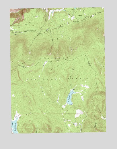
East Park Reservoir, UT USGS Topographic Map
Click on map above to begin viewing in our Map Viewer.

This topographic map contains these locations and features:
Feature Name Type Latitude Longitude GNIS ID View Map
Aztec SpringSpringN40.8567°W109.5607°1438315View Map
Big ParkFlatN40.7958°W109.5276°1438712View Map
Brush ParkFlatN40.7838°W109.5632°1439197View Map
Center Fork Eagle CreekStreamN40.8652°W109.5710°1439616View Map
Cub CreekStreamN40.8713°W109.6140°1440184View Map
Dyer ParkFlatN40.7619°W109.5557°1440754View Map
East Fork Eagle CreekStreamN40.8727°W109.5682°1440805View Map
East Park CampgroundLocaleN40.7811°W109.5535°1454731View Map
East Park DamDamN40.7783°W109.5457°1447961View Map
East Park ReservoirReservoirN40.7847°W109.5477°1447960View Map
Greens Lakes CampgroundLocaleN40.8733°W109.5374°1441489View Map
Lake CreekStreamN40.8741°W109.5401°1455971View Map
Lake ParkFlatN40.7847°W109.5315°1442417View Map
Lonesome ParkFlatN40.8194°W109.5796°1442886View Map
Meadow ParkFlatN40.8527°W109.6218°1443284View Map
Oaks Park ReservoirReservoirN40.7562°W109.6221°1444047View Map
Ross SpringSpringN40.8687°W109.5486°1445148View Map
Round ParkFlatN40.7586°W109.5413°1445173View Map
Skull Creek CampgroundLocaleN40.8650°W109.5260°1445639View Map

Note: Coordinates in the location and feature list above are referenced to NAD83 datum.


Copyright (C) 2008-2024 Ryan Niemi / Sunset Dynamics ... All Rights Reserved