TopoQuest Logo
Do you find TopoQuest useful?
Help keep TopoQuest running and adding new maps/features by donating!
Bitcoin:  19c7KJd3qBynnjoSw5npx9KScwjBe4ifkT
Litecoin:  LXs6TkuXGGXo1vDsWCkWVdjQX94eUKd6ui
Home View Maps Find Maps Find Places Resources & Links


Flaming Gorge, Utah Topographic Map

USGS Map Title: Flaming Gorge, UT
USGS Map MRC: 40109H5
DRG (GeoTIFF) Download: o40109h5.tif


Neighboring USGS Topographic Map Quads:


  Linwood Canyon, WY  
41109A6
 

  Haystack Buttes South, WY  
41109A5
 

  Minnies Gap, WY  
41109A4
 

  Manila, UT  
40109H6
 

  Flaming Gorge, UT  
40109H5
 

  Dutch John, UT  
40109H4
 

  Elk Park, UT  
40109G6
 

  East Park Reservoir, UT  
40109G5
 

  Mount Lena, UT  
40109G4


Map MRC Location:

N41°
W110°
N41°
W109°
H8 H7 H6 H5 H4 H3 H2 H1
G8 G7 G6 G5 G4 G3 G2 G1
F8 F7 F6 F5 F4 F3 F2 F1
E8 E7 E6 E5 E4 E3 E2 E1
D8 D7 D6 D5 D4 D3 D2 D1
C8 C7 C6 C5 C4 C3 C2 C1
B8 B7 B6 B5 B4 B3 B2 B1
A8 A7 A6 A5 A4 A3 A2 A1
N40°
W110°
N40°
W109°

Flaming Gorge, UT USGS 1:24K Topographic Map Preview:
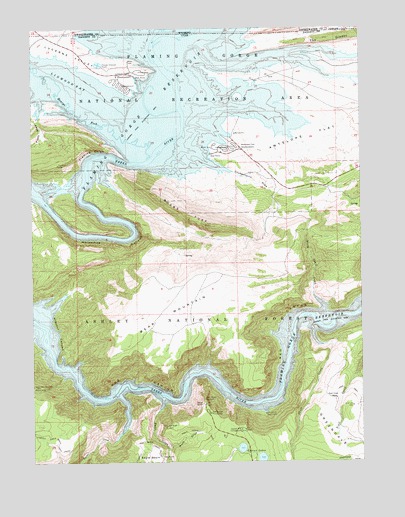
Flaming Gorge, UT USGS Topographic Map
Click on map above to begin viewing in our Map Viewer.

This topographic map contains these locations and features:
Feature Name Type Latitude Longitude GNIS ID View Map
Antelope Flat CampgroundLocaleN40.9661°W109.5515°1454648View Map
Antelope Flat CampgroundLocaleN40.9652°W109.5507°1450184View Map
Antelope Flat DevelopmentLocaleN40.9652°W109.5460°1438240View Map
Ashley FallsFallsN40.9166°W109.5004°1448090View Map
Bare Top MountainSummitN40.9208°W109.5674°1455866View Map
Boars TuskRidgeN40.9433°W109.5596°1438978View Map
Buck DrawValleyN40.8788°W109.5749°1439218View Map
Campbell DrawValleyN40.9236°W109.6126°1454699View Map
Canyon Rim CampgroundLocaleN40.8844°W109.5468°1439470View Map
Carter CreekStreamN40.8941°W109.5926°1439497View Map
Chokecherry DrawValleyN40.9605°W109.5560°1439714View Map
Daggett CountyCivilN40.8873°W109.5076°1448019View Map
Eagle BasinBasinN40.8758°W109.5815°1440757View Map
Eagle CreekStreamN40.8941°W109.5763°1440758View Map
Finch DrawValleyN40.9741°W109.6235°1441041View Map
Flaming Gorge (historical)ValleyN40.9625°W109.5896°1455280View Map
Flaming Gorge ValleyValleyN40.9555°W109.6093°1441115View Map
Gooseneck Boat CampLocaleN40.8888°W109.5376°1438056View Map
Greens LakesLakeN40.8759°W109.5391°1441488View Map
Henrys ForkStreamN40.9625°W109.5815°1441713View Map
Hideout CanyonValleyN40.9025°W109.6160°1441749View Map
Hideout Eagle Basin TrailTrailN40.8802°W109.5821°1441751View Map
Horseshoe CanyonValleyN40.9477°W109.6185°1428887View Map
Linwood BayBayN40.9833°W109.6040°1442641View Map
Lucerne Point Group SiteParkN40.9875°W109.5840°1448629View Map
Lucerne ValleyValleyN40.9816°W109.5888°1443037View Map
Lucerne Valley CampgroundLocaleN40.9833°W109.5899°1450183View Map
Lucerne Valley CampgroundLocaleN40.9836°W109.5907°1454808View Map
Lucerne Valley DevelopmentLocaleN40.9869°W109.5890°1443038View Map
Lucerne Valley MarinaLocaleN40.9847°W109.5851°1450186View Map
North Skull CreekStreamN40.9169°W109.5157°1443973View Map
Red Canyon LodgeLocaleN40.8755°W109.5015°1448900View Map
Red Canyon OverlookLocaleN40.8930°W109.5604°1444779View Map
Red Canyon Picnic AreaLocaleN40.8891°W109.5588°1444780View Map
Red Canyon Visitor CenterLocaleN40.8936°W109.5610°1450185View Map
Red Canyon Visitor CenterLocaleN40.8916°W109.5613°1448901View Map
Skull CreekStreamN40.9144°W109.5185°1445638View Map
Spring CreekStreamN40.9972°W109.5688°1446025View Map
Trail Creek RanchLocaleN40.8930°W109.5113°1446675View Map
West Fork Eagle CreekStreamN40.8766°W109.5749°1447140View Map

Note: Coordinates in the location and feature list above are referenced to NAD83 datum.


Copyright (C) 2008-2024 Ryan Niemi / Sunset Dynamics ... All Rights Reserved