TopoQuest Logo
Do you find TopoQuest useful?
Help keep TopoQuest running and adding new maps/features by donating!
Bitcoin:  19c7KJd3qBynnjoSw5npx9KScwjBe4ifkT
Litecoin:  LXs6TkuXGGXo1vDsWCkWVdjQX94eUKd6ui
Home View Maps Find Maps Find Places Resources & Links


Elburn, Illinois Topographic Map

USGS Map Title: Elburn, IL
USGS Map MRC: 41088H4
DRG (GeoTIFF) Download: o41088h4.tif


Neighboring USGS Topographic Map Quads:


  Hampshire, IL  
42088A5
 

  Pingree Grove, IL  
42088A4
 

  Elgin, IL  
42088A3
 

  Maple Park, IL  
41088H5
 

  Elburn, IL  
41088H4
 

  Geneva, IL  
41088H3
 

  Big Rock, IL  
41088G5
 

  Sugar Grove, IL  
41088G4
 

  Aurora North, IL  
41088G3


Map MRC Location:

N42°
W89°
N42°
W88°
H8 H7 H6 H5 H4 H3 H2 H1
G8 G7 G6 G5 G4 G3 G2 G1
F8 F7 F6 F5 F4 F3 F2 F1
E8 E7 E6 E5 E4 E3 E2 E1
D8 D7 D6 D5 D4 D3 D2 D1
C8 C7 C6 C5 C4 C3 C2 C1
B8 B7 B6 B5 B4 B3 B2 B1
A8 A7 A6 A5 A4 A3 A2 A1
N41°
W89°
N41°
W88°

Elburn, IL USGS 1:24K Topographic Map Preview:
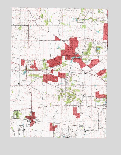
Elburn, IL USGS Topographic Map
Click on map above to begin viewing in our Map Viewer.

This topographic map contains these locations and features:
Feature Name Type Latitude Longitude GNIS ID View Map
Aeroview Airport (historical)AirportN41.9709°W88.4917°427455View Map
Appaloosa WestPopulated PlaceN41.9025°W88.4162°2025824View Map
Blackberry CemeteryCemeteryN41.8827°W88.4720°404508View Map
Briar GatePopulated PlaceN41.9664°W88.4220°2025829View Map
Broadview AcademySchoolN41.8761°W88.4229°404888View Map
BrooksidePopulated PlaceN41.9359°W88.4326°2025846View Map
Burning TreePopulated PlaceN41.9459°W88.4067°2025847View Map
Campton CemeteryCemeteryN41.9103°W88.4009°405534View Map
Campton County Forest PreserveParkN41.9303°W88.4162°1706191View Map
Campton HillsPopulated PlaceN41.9375°W88.3978°2357469View Map
Campton LakeReservoirN41.9517°W88.4067°1692111View Map
Campton Lake DamDamN41.9528°W88.4129°1692110View Map
Campton PinesPopulated PlaceN41.9175°W88.3887°2025848View Map
Campton Woods RunStreamN41.9111°W88.4066°2424833View Map
Community Congregational ChurchChurchN41.8936°W88.4720°2038327View Map
Congregational Church of Lily LakeChurchN41.9492°W88.4762°2038329View Map
Country Evangelical Covenant ChurchChurchN41.9909°W88.4637°1706193View Map
Deer RunPopulated PlaceN41.9484°W88.3937°2025851View Map
DillonfieldPopulated PlaceN41.8967°W88.4140°2025852View Map
ElburnPopulated PlaceN41.8922°W88.4723°407837View Map
Elburn and Countryside Fire Protection District Station 1BuildingN41.8925°W88.4705°2682107View Map
Elburn County Forest PreserveForestN41.8964°W88.4909°407838View Map
Elburn Police DepartmentBuildingN41.8918°W88.4692°2757007View Map
Elburn Post OfficePost OfficeN41.9010°W88.4713°1816252View Map
Empire HillsPopulated PlaceN41.9567°W88.4284°2025855View Map
Fair OaksPopulated PlaceN41.9586°W88.4015°2025857View Map
Far ViewPopulated PlaceN41.9570°W88.4179°2025858View Map
Forest HillsPopulated PlaceN41.9161°W88.4237°2025861View Map
FoxfieldPopulated PlaceN41.9317°W88.4420°2025862View Map
Garfield FarmLocaleN41.9109°W88.4023°2025863View Map
Grace Lutheran ChurchChurchN41.9475°W88.4767°1706190View Map
Gray Willow School (historical)SchoolN41.9692°W88.4345°1706195View Map
Griggs School (historical)SchoolN41.9959°W88.4776°1706192View Map
Happy HillsPopulated PlaceN41.9156°W88.3812°2025864View Map
HastingsPopulated PlaceN41.9689°W88.4023°2025865View Map
HedgerowPopulated PlaceN41.9614°W88.4267°2025868View Map
High PointPopulated PlaceN41.9203°W88.4334°2025871View Map
Homeward HillPopulated PlaceN41.9653°W88.3859°2025872View Map
Horseshoe LakeReservoirN41.9899°W88.4203°2771428View Map
Illinois Youth Center - Saint CharlesBuildingN41.9076°W88.3751°2740114View Map
Indian CreekPopulated PlaceN41.9467°W88.4845°2025874View Map
Johnsons Mound RunStreamN41.8924°W88.3876°2424834View Map
Kane CountyCivilN41.9389°W88.4286°424246View Map
Kings MillPopulated PlaceN41.9536°W88.4140°2025876View Map
L. M. Baker CemeteryCemeteryN41.9877°W88.4749°403825View Map
La FoxPopulated PlaceN41.8864°W88.4090°411636View Map
Lake CamptonLakeN41.9531°W88.4162°405535View Map
Lily LakePopulated PlaceN41.9489°W88.4779°412088View Map
Lily Lake CemeteryCemeteryN41.9535°W88.4772°412090View Map
Lily Lake ChurchChurchN41.9906°W88.4637°412091View Map
Lily Lake Elementary SchoolSchoolN41.9497°W88.4781°1816322View Map
Lily Lake RunStreamN41.9411°W88.4528°2424809View Map
Mary MeadowsPopulated PlaceN41.9384°W88.4467°2025890View Map
Native PrairiePopulated PlaceN41.8839°W88.4317°2025892View Map
New Hampshire CemeteryCemeteryN41.9297°W88.4799°414400View Map
Oak OpeningsPopulated PlaceN41.9331°W88.4645°2025893View Map
Plato CornersPopulated PlaceN41.9870°W88.4051°1718942View Map
Pouley RunStreamN41.8895°W88.4448°2424831View Map
Pouley Run NorthStreamN41.8915°W88.4515°2424832View Map
Route 38 BranchStreamN41.9004°W88.4413°2089564View Map
Saint Gall CemeteryCemeteryN41.8993°W88.4718°417297View Map
Saint Gall's ChurchChurchN41.8936°W88.4729°2038328View Map
Silver Glen MeadowsPopulated PlaceN41.9731°W88.4259°2025900View Map
Silver Glen RunStreamN41.9771°W88.3815°2424830View Map
Split Rail FarmPopulated PlaceN41.9650°W88.3929°2025901View Map
Spring Valley LakeReservoirN41.9778°W88.3877°1692113View Map
Spring Valley Lake DamDamN41.9767°W88.3851°1692112View Map
Stewart School (historical)SchoolN41.9259°W88.4790°1706194View Map
Still MeadowsPopulated PlaceN41.8850°W88.4456°2025903View Map
Sunset VillaPopulated PlaceN41.9084°W88.4281°2025904View Map
The KnollsPopulated PlaceN41.9567°W88.4340°2025908View Map
Township of CamptonCivilN41.9404°W88.4327°428755View Map
Tucker RunStreamN41.9519°W88.3967°2424829View Map
Turtle Rock LakeReservoirN41.9889°W88.4157°2770986View Map
Village of Campton HillsCivilN41.9498°W88.4167°2357470View Map
Village of ElburnCivilN41.8851°W88.4759°2398795View Map
Village of Lily LakeCivilN41.9518°W88.4743°2398437View Map
WascoPopulated PlaceN41.9381°W88.4045°420545View Map
Wasco Baptist ChurchChurchN41.9370°W88.4042°2038332View Map
Wasco Elementary SchoolSchoolN41.9372°W88.4034°1816416View Map
Wasco Post OfficePost OfficeN41.9381°W88.4049°2788713View Map
WeybridgePopulated PlaceN41.9709°W88.4170°2025913View Map
Whitney CemeteryCemeteryN41.9472°W88.4034°421110View Map
WideviewPopulated PlaceN41.9386°W88.3817°2025931View Map

Note: Coordinates in the location and feature list above are referenced to NAD83 datum.


Copyright (C) 2008-2024 Ryan Niemi / Sunset Dynamics ... All Rights Reserved