TopoQuest Logo
Do you find TopoQuest useful?
Help keep TopoQuest running and adding new maps/features by donating!
Bitcoin:  19c7KJd3qBynnjoSw5npx9KScwjBe4ifkT
Litecoin:  LXs6TkuXGGXo1vDsWCkWVdjQX94eUKd6ui
Home View Maps Find Maps Find Places Resources & Links


Etowah, Arkansas Topographic Map

USGS Map Title: Etowah, AR
USGS Map MRC: 35090F2
DRG (GeoTIFF) Download: o35090f2.tif


Neighboring USGS Topographic Map Quads:


  Caraway, AR  
35090G3
 

  Manila South, AR  
35090G2
 

  Dell, AR  
35090G1
 

  Rivervale, AR  
35090F3
 

  Etowah, AR  
35090F2
 

  Keiser, AR  
35090F1
 

  Lepanto, AR  
35090E3
 

  Joiner, AR  
35090E2
 

  Wilson, AR  
35090E1


Map MRC Location:

N36°
W91°
N36°
W90°
H8 H7 H6 H5 H4 H3 H2 H1
G8 G7 G6 G5 G4 G3 G2 G1
F8 F7 F6 F5 F4 F3 F2 F1
E8 E7 E6 E5 E4 E3 E2 E1
D8 D7 D6 D5 D4 D3 D2 D1
C8 C7 C6 C5 C4 C3 C2 C1
B8 B7 B6 B5 B4 B3 B2 B1
A8 A7 A6 A5 A4 A3 A2 A1
N35°
W91°
N35°
W90°

Etowah, AR USGS 1:24K Topographic Map Preview:
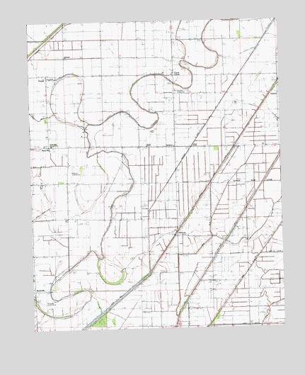
Etowah, AR USGS Topographic Map
Click on map above to begin viewing in our Map Viewer.

This topographic map contains these locations and features:
Feature Name Type Latitude Longitude GNIS ID View Map
AthelstanPopulated PlaceN35.6981°W90.1784°57285View Map
BondsvillePopulated PlaceN35.6412°W90.2487°58691View Map
Bondsville Landing Strip (historical)AirportN35.6370°W90.2437°64905View Map
Bowman Landing Strip (historical)AirportN35.6890°W90.2295°64906View Map
Brinkleys Chapel Baptist ChurchChurchN35.6990°W90.1923°76420View Map
Caney Old RiverLakeN35.6445°W90.2101°61850View Map
Carrol CornerPopulated PlaceN35.7287°W90.1787°57515View Map
Church of ChristChurchN35.7204°W90.1784°61845View Map
Church of GodChurchN35.6987°W90.1693°47776View Map
Ditch Number 1CanalN35.6354°W90.2098°82025View Map
Ditch Number 18CanalN35.7429°W90.2257°82121View Map
Ditch Number 19CanalN35.7412°W90.1745°81949View Map
Ditch Number 40bCanalN35.6454°W90.1454°82257View Map
Ditch Number 5CanalN35.6623°W90.2004°82296View Map
Ditch Number 58CanalN35.6848°W90.1509°82328View Map
Ditch Number 8CanalN35.7365°W90.1415°82396View Map
EastviewPopulated PlaceN35.7198°W90.1265°57696View Map
EtowahPopulated PlaceN35.7290°W90.2323°57729View Map
Etowah Baptist ChurchChurchN35.7287°W90.2412°61928View Map
Etowah Fire Volunteer DepartmentBuildingN35.7274°W90.2372°2116408View Map
Etowah Police DepartmentBuildingN35.7274°W90.2402°2118514View Map
Etowah Post OfficePost OfficeN35.7271°W90.2404°2781920View Map
Flint BendBendN35.6376°W90.2498°67175View Map
Gant CemeteryCemeteryN35.7051°W90.1895°61846View Map
Garden Point United Methodist ChurchChurchN35.7004°W90.2390°78553View Map
Grays BendBendN35.7320°W90.1562°61844View Map
Hatcher SchoolSchoolN35.6695°W90.2323°49934View Map
Jacksons IslandIslandN35.7187°W90.2307°61847View Map
Kochtitzky Ditch Number 1CanalN35.7104°W90.1606°82467View Map
Lilly Robertson Store (historical)LocaleN35.6695°W90.2101°61849View Map
McGinnis Landing Strip (historical)AirportN35.7217°W90.1737°64907View Map
New Bethel ChurchChurchN35.6615°W90.1426°52629View Map
Pentecostal ChurchChurchN35.7354°W90.2329°53278View Map
Red Line SchoolSchoolN35.6998°W90.2223°53953View Map
Redmond Old RiverStreamN35.6967°W90.2165°61848View Map
Shady Bend SchoolSchoolN35.7345°W90.1951°54684View Map
Stillman SchoolSchoolN35.6379°W90.2484°55236View Map
The Church of GodChurchN35.7284°W90.2262°55507View Map
Three WayPopulated PlaceN35.6990°W90.2440°78552View Map
Three Way CemeteryCemeteryN35.6998°W90.2370°55562View Map
Town of EtowahCivilN35.7222°W90.2316°2406467View Map
Township of Little RiverCivilN35.7174°W90.1976°69663View Map
Tyronza Cut-offGutN35.6306°W90.2082°61851View Map
Tyronza Sunk LandsFlatN35.6901°W90.1356°78610View Map

Note: Coordinates in the location and feature list above are referenced to NAD83 datum.


Copyright (C) 2008-2024 Ryan Niemi / Sunset Dynamics ... All Rights Reserved