TopoQuest Logo
Do you find TopoQuest useful?
Help keep TopoQuest running and adding new maps/features by donating!
Bitcoin:  19c7KJd3qBynnjoSw5npx9KScwjBe4ifkT
Litecoin:  LXs6TkuXGGXo1vDsWCkWVdjQX94eUKd6ui
Home View Maps Find Maps Find Places Resources & Links


Fiske, Louisiana Topographic Map

USGS Map Title: Fiske, LA
USGS Map MRC: 32091H4
DRG (GeoTIFF) Download: o32091h4.tif


Neighboring USGS Topographic Map Quads:


  Wilmot, AR  
33091A5
 

  Empire, AR  
33091A4
 

  Eudora South, AR  
33091A3
 

  Laark, LA  
32091H5
 

  Fiske, LA  
32091H4
 

  Kilbourne, LA  
32091H3
 

  Goodwill, LA  
32091G5
 

  Oak Grove, LA  
32091G4
 

  Baxter Bayou, LA  
32091G3


Map MRC Location:

N33°
W92°
N33°
W91°
H8 H7 H6 H5 H4 H3 H2 H1
G8 G7 G6 G5 G4 G3 G2 G1
F8 F7 F6 F5 F4 F3 F2 F1
E8 E7 E6 E5 E4 E3 E2 E1
D8 D7 D6 D5 D4 D3 D2 D1
C8 C7 C6 C5 C4 C3 C2 C1
B8 B7 B6 B5 B4 B3 B2 B1
A8 A7 A6 A5 A4 A3 A2 A1
N32°
W92°
N32°
W91°

Fiske, LA USGS 1:24K Topographic Map Preview:
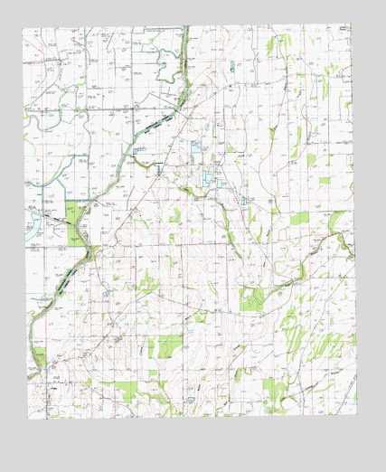
Fiske, LA USGS Topographic Map
Click on map above to begin viewing in our Map Viewer.

This topographic map contains these locations and features:
Feature Name Type Latitude Longitude GNIS ID View Map
Beulah ChurchChurchN32.9010°W91.4704°533004View Map
Camp BayouStreamN32.9362°W91.4801°47306View Map
ConcordPopulated PlaceN32.9554°W91.4468°540625View Map
Concord ChurchChurchN32.9565°W91.4462°534076View Map
Concord Volunteer Fire Department Central StationBuildingN32.9555°W91.4256°2672902View Map
Concord Volunteer Fire Department Macedonia StationBuildingN32.9815°W91.4200°2673018View Map
Costello AirportAirportN32.9688°W91.4261°2676760View Map
Dam 73DamN32.8997°W91.4983°554182View Map
Dam 76DamN32.9418°W91.4769°554183View Map
Dam 78DamN32.9766°W91.4395°554184View Map
Dam 80DamN32.9895°W91.4388°554185View Map
FiskePopulated PlaceN32.8868°W91.4923°543204View Map
Fiske Union School (historical)SchoolN32.8824°W91.4919°534970View Map
Fiske Union Volunteer Fire Department Central StationBuildingN32.8870°W91.4898°2673002View Map
Fiske Union Volunteer Fire Department North StationBuildingN32.9299°W91.4393°2673014View Map
Green Cove ChurchChurchN32.8896°W91.3754°535385View Map
Macedonia ChurchChurchN32.9807°W91.4212°536801View Map
Parish Governing Authority District ECivilN32.9527°W91.3799°1930323View Map
Pine BayouStreamN32.9157°W91.4134°538158View Map
Saint Clemith ChurchChurchN32.9487°W91.4234°538828View Map
Tiger BayouStreamN32.9590°W91.4610°539922View Map

Note: Coordinates in the location and feature list above are referenced to NAD83 datum.


Copyright (C) 2008-2024 Ryan Niemi / Sunset Dynamics ... All Rights Reserved