TopoQuest Logo
Do you find TopoQuest useful?
Help keep TopoQuest running and adding new maps/features by donating!
Bitcoin:  19c7KJd3qBynnjoSw5npx9KScwjBe4ifkT
Litecoin:  LXs6TkuXGGXo1vDsWCkWVdjQX94eUKd6ui
Home View Maps Find Maps Find Places Resources & Links


Flintville, Tennessee Topographic Map

USGS Map Title: Flintville, TN
USGS Map MRC: 35086A4
DRG (GeoTIFF) Download: o35086a4.tif


Neighboring USGS Topographic Map Quads:


  Fayetteville, TN  
35086B5
 

  Mulberry, TN  
35086B4
 

  Lois, TN  
35086B3
 

  Lincoln, TN  
35086A5
 

  Flintville, TN  
35086A4
 

  Huntland, TN  
35086A3
 

  Fisk, AL  
34086H5
 

  New Market, AL  
34086H4
 

  King Cove, AL  
34086H3


Map MRC Location:

N36°
W87°
N36°
W86°
H8 H7 H6 H5 H4 H3 H2 H1
G8 G7 G6 G5 G4 G3 G2 G1
F8 F7 F6 F5 F4 F3 F2 F1
E8 E7 E6 E5 E4 E3 E2 E1
D8 D7 D6 D5 D4 D3 D2 D1
C8 C7 C6 C5 C4 C3 C2 C1
B8 B7 B6 B5 B4 B3 B2 B1
A8 A7 A6 A5 A4 A3 A2 A1
N35°
W87°
N35°
W86°

Flintville, TN USGS 1:24K Topographic Map Preview:
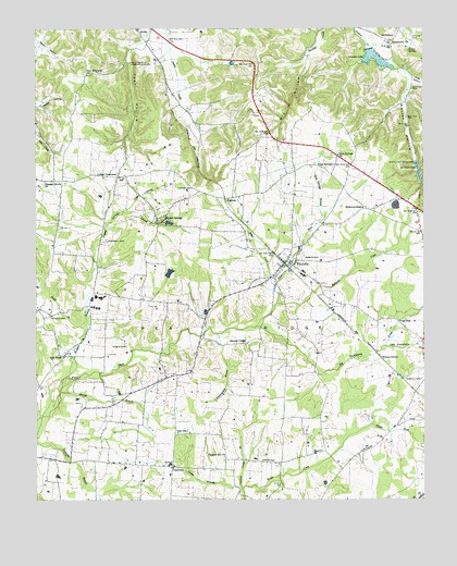
Flintville, TN USGS Topographic Map
Click on map above to begin viewing in our Map Viewer.

This topographic map contains these locations and features:
Feature Name Type Latitude Longitude GNIS ID View Map
Baxter CemeteryCemeteryN35.0051°W86.4305°1645170View Map
Beavers CemeteryCemeteryN35.0245°W86.4880°1645175View Map
Benson CemeteryCemeteryN35.1017°W86.4300°1645176View Map
Benson CemeteryCemeteryN35.1073°W86.4308°1645177View Map
Benson School (historical)SchoolN35.0959°W86.4280°1316177View Map
Big Huckleberry CreekStreamN35.0456°W86.4292°1277330View Map
Bostick CemeteryCemeteryN35.1087°W86.3786°1278009View Map
Brannon Cotton FarmLocaleN35.0281°W86.3794°2724570View Map
Bray CemeteryCemeteryN35.0570°W86.4794°1645183View Map
BrightonPopulated PlaceN35.0801°W86.4392°1278390View Map
Campbell CemeteryCemeteryN35.0690°W86.4772°1279423View Map
Carter CemeteryCemeteryN35.0829°W86.4494°1279784View Map
Commissioner District 7CivilN35.1001°W86.4018°2464627View Map
Corder CrossroadsPopulated PlaceN35.0856°W86.4733°1306110View Map
Corder Spring BranchStreamN35.0762°W86.4703°1281297View Map
Corders Crossroads School (historical)SchoolN35.0865°W86.4736°1316188View Map
Crystal SpringsPopulated PlaceN35.0743°W86.4608°1281786View Map
Crystal Springs BranchStreamN35.0615°W86.4811°1281787View Map
Cunningham BranchStreamN35.0440°W86.4414°1281860View Map
Drach FarmLocaleN35.0939°W86.3917°2724567View Map
Fanning CemeteryCemeteryN35.1020°W86.4517°1645213View Map
Fayetteville Pumping StationLocaleN35.1156°W86.4697°1284176View Map
FlintvillePopulated PlaceN35.0626°W86.4197°1284492View Map
Flintville CemeteryCemeteryN35.0626°W86.4189°1645217View Map
Flintville CemeteryCemeteryN35.0673°W86.4167°1645218View Map
Flintville Census Designated PlaceCensusN35.0602°W86.4165°2586054View Map
Flintville Division (historical)CensusN35.0420°W86.4119°1648832View Map
Flintville Elementary SchoolSchoolN35.0604°W86.4136°1316201View Map
Flintville First Baptist ChurchChurchN35.0623°W86.4183°1643957View Map
Flintville Junior High SchoolSchoolN35.0595°W86.4139°1316202View Map
Flintville Post OfficePost OfficeN35.0621°W86.4209°1650326View Map
Flintville Volunteer Fire RescueBuildingN35.0627°W86.4194°2654216View Map
Gin HollowValleyN35.1168°W86.4123°1285446View Map
Golden CemeteryCemeteryN35.0987°W86.4461°1645225View Map
Gray CemeteryCemeteryN35.1070°W86.3947°1645226View Map
Gum SpringSpringN35.0895°W86.4085°1310346View Map
Gum SpringsPopulated PlaceN35.0887°W86.4089°1286426View Map
Gum Springs BranchStreamN35.0737°W86.4078°1286427View Map
Gum Springs CemeteryCemeteryN35.0887°W86.4036°1316204View Map
Gum Springs ChurchChurchN35.0915°W86.4025°1286429View Map
Harbin BranchStreamN35.0223°W86.4980°1269622View Map
Harris CemeteryCemeteryN35.0959°W86.4328°1645237View Map
Harris-Jean CemeteryCemeteryN35.0879°W86.4383°1645238View Map
Hester BranchStreamN35.0443°W86.4842°1287517View Map
Hester CemeteryCemeteryN35.0490°W86.4947°1287518View Map
Hog HollowValleyN35.1115°W86.3784°1287982View Map
Hopkins-Eastland CemeteryCemeteryN35.0415°W86.4880°1645241View Map
Hunter CemeteryCemeteryN35.1173°W86.4114°1645247View Map
Jean CemeteryCemeteryN35.0909°W86.4378°1645250View Map
Kelso SpringSpringN35.1154°W86.4705°1310352View Map
Kilpatrick CemeteryCemeteryN35.0479°W86.4469°1645255View Map
Kilpatrick CemeteryCemeteryN35.0356°W86.4111°1645256View Map
Lincoln LakeReservoirN35.1168°W86.3903°1291306View Map
Lincoln Lake DamDamN35.1195°W86.3928°1307059View Map
Little Huckleberry CreekStreamN35.0406°W86.3875°1291533View Map
Lucy Memorial ChurchChurchN35.1129°W86.4833°1292265View Map
Maddox FarmLocaleN35.0797°W86.4342°2724568View Map
Marty FarmsLocaleN35.0222°W86.4533°2724565View Map
McClellan CemeteryCemeteryN35.1201°W86.4750°1645272View Map
McCracken School (historical)SchoolN35.0037°W86.4222°1316228View Map
McNeal CemeteryCemeteryN35.0373°W86.4658°1645283View Map
Merrill BranchStreamN35.0290°W86.4922°1293627View Map
Milners SwitchLocaleN35.0376°W86.3889°1294011View Map
Morgan CemeteryCemeteryN35.0320°W86.3758°1294355View Map
Mulepen CreekStreamN35.0523°W86.4225°1295071View Map
New HopePopulated PlaceN35.0381°W86.4908°1295502View Map
New Hope Baptist ChurchChurchN35.0381°W86.4914°1643965View Map
Nixon SpringSpringN35.1193°W86.3797°1295778View Map
Patterson CemeteryCemeteryN35.0112°W86.4780°1645296View Map
Pleasant Grove ChurchChurchN35.0848°W86.4967°1297809View Map
Pleasant Hill CemeteryCemeteryN35.0104°W86.4394°1645301View Map
Pleasant Hill ChurchChurchN35.0115°W86.4392°1297859View Map
Pryor CemeteryCemeteryN35.0934°W86.4450°1645306View Map
Puncheon Camp BranchStreamN35.0029°W86.4333°1298690View Map
Raby Brothers FarmLocaleN35.0667°W86.4886°2724598View Map
Simms CemeteryCemeteryN35.0254°W86.4844°1645322View Map
Smith CemeteryCemeteryN35.1184°W86.3942°1645325View Map
SmithlandPopulated PlaceN35.1218°W86.3855°1270710View Map
Snoddy CemeteryCemeteryN35.1131°W86.4425°1645326View Map
Southworth CemeteryCemeteryN35.0473°W86.4811°1645328View Map
Steelman LakeReservoirN35.0603°W86.4569°1301528View Map
Steelman Lake DamDamN35.0584°W86.4567°1301529View Map
Stewart ChapelChurchN35.0412°W86.4322°1303835View Map
Stiles CreekStreamN35.0570°W86.4225°1271382View Map
Sycamore SwampPopulated PlaceN35.0773°W86.3930°1314372View Map
Taylor CemeteryCemeteryN35.1042°W86.4855°1645333View Map
Taylor CemeteryCemeteryN35.1231°W86.3786°1272191View Map
Taylor-Gray CemeteryCemeteryN35.1184°W86.4653°1645334View Map
Teal HollowValleyN35.1196°W86.4681°1272264View Map
Teal Hollow CreekStreamN35.1240°W86.4578°1312901View Map
Tilda HoleSpringN35.0476°W86.3830°1272637View Map
Trotters BranchStreamN35.0326°W86.4903°1304176View Map
Vann SchoolSchoolN35.0179°W86.4542°1273379View Map
VanntownPopulated PlaceN35.0090°W86.4561°1273382View Map
Vanntown Volunteer Fire and RescueBuildingN35.0090°W86.4529°2654205View Map
Vinsons Mill SpringsSpringN35.0829°W86.3755°1310367View Map
Warren CemeteryCemeteryN35.0881°W86.3769°1273822View Map
Warren HollowValleyN35.1106°W86.3791°1273834View Map
Whitworth CemeteryCemeteryN35.0598°W86.4778°1645348View Map
Wicks CemeteryCemeteryN35.0409°W86.4708°1274511View Map

Note: Coordinates in the location and feature list above are referenced to NAD83 datum.


Copyright (C) 2008-2024 Ryan Niemi / Sunset Dynamics ... All Rights Reserved