TopoQuest Logo
Do you find TopoQuest useful?
Help keep TopoQuest running and adding new maps/features by donating!
Bitcoin:  19c7KJd3qBynnjoSw5npx9KScwjBe4ifkT
Litecoin:  LXs6TkuXGGXo1vDsWCkWVdjQX94eUKd6ui
Home View Maps Find Maps Find Places Resources & Links


Huntland, Tennessee Topographic Map

USGS Map Title: Huntland, TN
USGS Map MRC: 35086A3
DRG (GeoTIFF) Download: o35086a3.tif


Neighboring USGS Topographic Map Quads:


  Mulberry, TN  
35086B4
 

  Lois, TN  
35086B3
 

  Belvidere, TN  
35086B2
 

  Flintville, TN  
35086A4
 

  Huntland, TN  
35086A3
 

  Beans Creek, TN  
35086A2
 

  New Market, AL  
34086H4
 

  King Cove, AL  
34086H3
 

  Estill Fork, AL  
34086H2


Map MRC Location:

N36°
W87°
N36°
W86°
H8 H7 H6 H5 H4 H3 H2 H1
G8 G7 G6 G5 G4 G3 G2 G1
F8 F7 F6 F5 F4 F3 F2 F1
E8 E7 E6 E5 E4 E3 E2 E1
D8 D7 D6 D5 D4 D3 D2 D1
C8 C7 C6 C5 C4 C3 C2 C1
B8 B7 B6 B5 B4 B3 B2 B1
A8 A7 A6 A5 A4 A3 A2 A1
N35°
W87°
N35°
W86°

Huntland, TN USGS 1:24K Topographic Map Preview:
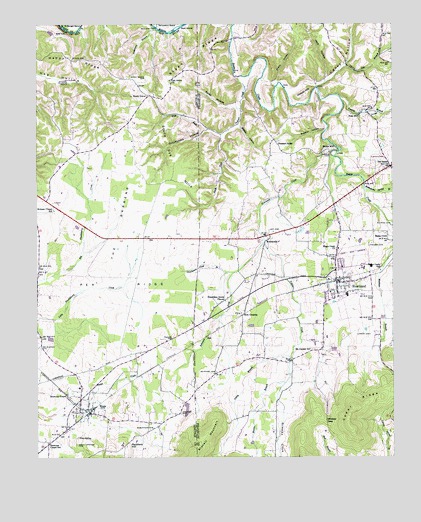
Huntland, TN USGS Topographic Map
Click on map above to begin viewing in our Map Viewer.

This topographic map contains these locations and features:
Feature Name Type Latitude Longitude GNIS ID View Map
Aqua Valley FarmsLocaleN35.0281°W86.3456°2724571View Map
Arnold CemeteryCemeteryN35.1192°W86.3714°1645165View Map
Arnold HollowValleyN35.0947°W86.3151°1647463View Map
Beans Creek ChurchChurchN35.0604°W86.2697°1305011View Map
Beans Creek SchoolSchoolN35.0540°W86.2544°1276548View Map
Bradley FarmsLocaleN35.0611°W86.3325°2724572View Map
BranchvillePopulated PlaceN35.0629°W86.2939°1278229View Map
Brazelton FarmsLocaleN35.0539°W86.3178°2724575View Map
Brown CemeteryCemeteryN35.0881°W86.2719°1278519View Map
Brown MillPopulated PlaceN35.0895°W86.2700°1314743View Map
Caney HollowValleyN35.1054°W86.2848°1279589View Map
Caney Hollow CreekStreamN35.1070°W86.2767°1279591View Map
Cave SpringSpringN35.0061°W86.3605°1279941View Map
Cherry HollowValleyN35.1085°W86.2913°1280351View Map
Commissioner District 3CivilN35.1044°W86.2512°2464143View Map
Damron CemeteryCemeteryN35.0131°W86.3244°1306258View Map
Dog BranchStreamN35.1131°W86.2664°1282584View Map
Donaldson Grove ChurchChurchN35.0454°W86.3086°1306379View Map
EloraPopulated PlaceN35.0134°W86.3558°1283729View Map
Elora CemeteryCemeteryN35.0187°W86.3628°1645211View Map
Elora Post OfficePost OfficeN35.0137°W86.3568°1650324View Map
Elora School (historical)SchoolN35.0204°W86.3603°1316195View Map
Elora Volunteer Fire RescueBuildingN35.0130°W86.3568°2654217View Map
Eskridge CemeteryCemeteryN35.0981°W86.2664°1318370View Map
Factory BranchStreamN35.1037°W86.2680°1283955View Map
Falls MillPopulated PlaceN35.0987°W86.2614°1315048View Map
Goat IslandIslandN35.1237°W86.3261°1285544View Map
Gonder CemeteryCemeteryN35.0762°W86.2661°1318364View Map
Greasy CoveValleyN35.0147°W86.2885°1269604View Map
Happy RidgeRidgeN35.1140°W86.3608°1286775View Map
Harris Poultry FarmLocaleN35.0567°W86.3053°2724573View Map
Holman CemeteryCemeteryN35.1154°W86.3647°1316207View Map
Holman Chapel (historical)ChurchN35.0709°W86.3689°1316208View Map
Holman Chapel SchoolSchoolN35.0715°W86.3686°1288126View Map
Hunt-Larkin CemeteryCemeteryN35.0329°W86.2744°1318360View Map
HuntlandPopulated PlaceN35.0512°W86.2697°1288762View Map
Huntland City HallBuildingN35.0543°W86.2692°1318363View Map
Huntland High SchoolSchoolN35.0468°W86.2661°1318361View Map
Huntland Police DepartmentBuildingN35.0538°W86.2681°2765914View Map
Huntland Post OfficePost OfficeN35.0503°W86.2685°1650982View Map
Huntland Volunteer Fire DepartmentBuildingN35.0538°W86.2682°2654441View Map
Indian CreekStreamN35.1098°W86.3050°1288942View Map
Jack HollowValleyN35.1098°W86.2728°1289151View Map
Jenny BranchStreamN35.0290°W86.2858°1289387View Map
Keith HollowValleyN35.1012°W86.3043°1289978View Map
Larkin CemeteryCemeteryN35.0354°W86.2578°1290643View Map
Lee CemeteryCemeteryN35.0656°W86.2930°1290942View Map
Liberty Church (historical)ChurchN35.0112°W86.3305°1316218View Map
Lipscomb CemeteryCemeteryN35.0617°W86.2586°1291356View Map
Martin BranchStreamN35.0218°W86.2880°122313View Map
McClue CemeteryCemeteryN35.0248°W86.3119°1293165View Map
Moore Memorial CemeteryCemeteryN35.0523°W86.2650°1318362View Map
Moseley-Simmons CemeteryCemeteryN35.0823°W86.2519°1318367View Map
Mount CarmelPopulated PlaceN35.0309°W86.2761°1647462View Map
Mount Carmel CemeteryCemeteryN35.0312°W86.2783°1318359View Map
Mount Carmel ChurchChurchN35.0312°W86.2789°1294572View Map
NeilPopulated PlaceN35.0351°W86.3153°1315580View Map
Oak Grove Baptist ChurchChurchN35.1090°W86.3278°1296080View Map
Old Beans Creek CemeteryCemeteryN35.0829°W86.2539°1318366View Map
Old Dam FordCrossingN35.1240°W86.3328°1296296View Map
Old SalemPopulated PlaceN35.0840°W86.2505°1296363View Map
Omohundro HollowValleyN35.0946°W86.3151°1296433View Map
Patrick CemeteryCemeteryN35.0670°W86.2508°1296914View Map
Payne Chapel (historical)ChurchN35.0284°W86.2864°1318358View Map
Peddlers HillSummitN35.0029°W86.3453°1297102View Map
Peddlers Hill DairyLocaleN35.0058°W86.3406°2724569View Map
Persimmon Pond BranchStreamN35.0534°W86.3055°1297233View Map
Pleasant RidgeLocaleN35.0918°W86.2917°1297905View Map
Pleasant Ridge Baptist ChurchChurchN35.0884°W86.2886°1318368View Map
Pleasant Ridge CemeteryCemeteryN35.0912°W86.2900°1318369View Map
Pleasant Ridge School (historical)SchoolN35.0870°W86.2925°1318356View Map
Potato HillSummitN35.1045°W86.2814°1298329View Map
Rattlesnake Spring BranchStreamN35.0776°W86.2597°1298956View Map
Rich CrossingLocaleN35.0412°W86.3025°1315803View Map
Roberts CemeteryCemeteryN35.0751°W86.2653°1318365View Map
Robertson CemeteryCemeteryN35.0087°W86.3339°1299662View Map
Robinson CreekStreamN35.0906°W86.2717°1299702View Map
Rocky Springs CemeteryCemeteryN35.0040°W86.3611°1299932View Map
Russell CemeteryCemeteryN35.0273°W86.3042°1318355View Map
Shady GrovePopulated PlaceN35.1043°W86.3353°1315900View Map
Shady Grove CemeteryCemeteryN35.1090°W86.3364°1301161View Map
Shady Grove School (historical)SchoolN35.1070°W86.3392°1316244View Map
Simmons ChapelChurchN35.0184°W86.3644°1270312View Map
Simmons Chapel SchoolSchoolN35.0045°W86.3711°1270313View Map
Skeet RidgeRidgeN35.1162°W86.3203°1270423View Map
South Fork Indian CreekStreamN35.0934°W86.3103°1270871View Map
Station HollowValleyN35.0957°W86.3036°1271282View Map
Stiles CemeteryCemeteryN35.1151°W86.3622°1303843View Map
Stone Dye HillsRidgeN35.0848°W86.3264°1271491View Map
Stovall MountainSummitN35.0054°W86.3172°1271554View Map
Sulphur HollowValleyN35.0945°W86.2739°1271783View Map
Syler CemeteryCemeteryN35.1192°W86.2953°1318357View Map
Taylor CreekStreamN35.0620°W86.2950°1272230View Map
Taylor FarmLocaleN35.0481°W86.3081°2724574View Map
Templeton BendBendN35.1240°W86.3286°1272290View Map
The BarrensAreaN35.0659°W86.3464°1272365View Map
Town of HuntlandCivilN35.0580°W86.2691°2405875View Map
West Fork Indian CreekStreamN35.0934°W86.3100°1274177View Map
Whites GapGapN35.0109°W86.2739°1304558View Map

Note: Coordinates in the location and feature list above are referenced to NAD83 datum.


Copyright (C) 2008-2024 Ryan Niemi / Sunset Dynamics ... All Rights Reserved