TopoQuest Logo
Do you find TopoQuest useful?
Help keep TopoQuest running and adding new maps/features by donating!
Bitcoin:  19c7KJd3qBynnjoSw5npx9KScwjBe4ifkT
Litecoin:  LXs6TkuXGGXo1vDsWCkWVdjQX94eUKd6ui
Home View Maps Find Maps Find Places Resources & Links


French Village, Missouri Topographic Map

USGS Map Title: French Village, MO
USGS Map MRC: 37090H4
DRG (GeoTIFF) Download: o37090h4.tif


Neighboring USGS Topographic Map Quads:


  Vineland, MO  
38090A5
 

  Halifax, MO  
38090A4
 

  Danby, MO  
38090A3
 

  Bonne Terre, MO  
37090H5
 

  French Village, MO  
37090H4
 

  Lawrenceton, MO  
37090H3
 

  Flat River, MO  
37090G5
 

  Farmington, MO  
37090G4
 

  Sprott, MO  
37090G3


Map MRC Location:

N38°
W91°
N38°
W90°
H8 H7 H6 H5 H4 H3 H2 H1
G8 G7 G6 G5 G4 G3 G2 G1
F8 F7 F6 F5 F4 F3 F2 F1
E8 E7 E6 E5 E4 E3 E2 E1
D8 D7 D6 D5 D4 D3 D2 D1
C8 C7 C6 C5 C4 C3 C2 C1
B8 B7 B6 B5 B4 B3 B2 B1
A8 A7 A6 A5 A4 A3 A2 A1
N37°
W91°
N37°
W90°

French Village, MO USGS 1:24K Topographic Map Preview:
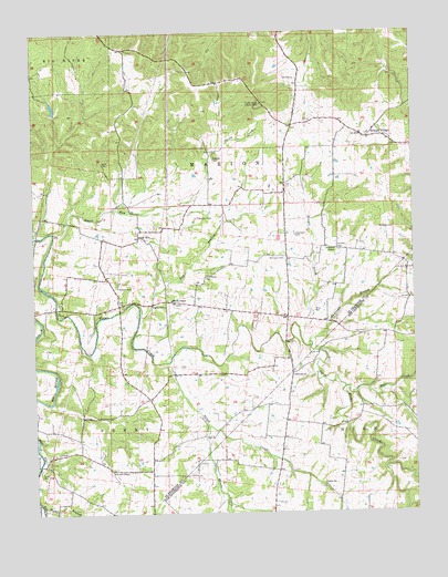
French Village, MO USGS Topographic Map
Click on map above to begin viewing in our Map Viewer.

This topographic map contains these locations and features:
Feature Name Type Latitude Longitude GNIS ID View Map
Andrews BranchStreamN37.9195°W90.4098°755689View Map
Ashburn CemeteryCemeteryN37.9338°W90.4727°755701View Map
Aulsbury ChapelChurchN37.9434°W90.4007°755707View Map
Bear CreekStreamN37.9076°W90.3982°713796View Map
Big River Fire Protection District Station 2BuildingN37.9307°W90.4260°2620886View Map
Bouyer CreekStreamN37.9220°W90.4129°755806View Map
Byington CemeteryCemeteryN37.9520°W90.4457°755842View Map
Cedar Falls BranchStreamN37.8995°W90.4762°757843View Map
Cedar Falls School (historical)SchoolN37.8878°W90.4771°757840View Map
Cedar RunStreamN37.9042°W90.4943°757844View Map
Cruncleton CemeteryCemeteryN37.9475°W90.4140°755953View Map
De Grant CemeteryCemeteryN37.9434°W90.3996°755979View Map
Dry BranchStreamN37.9267°W90.4654°755999View Map
Fairview ChurchChurchN37.9109°W90.4154°717781View Map
Flat RiverStreamN37.8920°W90.4998°756059View Map
French VillagePopulated PlaceN37.9726°W90.3898°756081View Map
French Village Lookout TowerTowerN37.9814°W90.4248°756082View Map
French Village School (historical)SchoolN37.9759°W90.3979°757846View Map
Hall CemeteryCemeteryN37.9879°W90.4128°756141View Map
Hazel RunPopulated PlaceN37.9470°W90.4657°756170View Map
Hazel RunStreamN37.9487°W90.4932°756171View Map
Herod CemeteryCemeteryN37.8867°W90.4985°756174View Map
Jacobs CreekStreamN37.9537°W90.4660°756222View Map
JaydeeLocaleN37.9262°W90.4168°756959View Map
Jennings School (historical)SchoolN37.8892°W90.4410°737617View Map
Kerlagon CemeteryCemeteryN37.9489°W90.3861°756244View Map
Lambeth School (historical)SchoolN37.9373°W90.4840°757839View Map
Marvin ChapelChurchN37.9306°W90.4551°756354View Map
McCreary CemeteryCemeteryN37.9414°W90.4178°756368View Map
Mostiller CemeteryCemeteryN37.9673°W90.4404°756412View Map
Mostiller School (historical)SchoolN37.9670°W90.4415°757841View Map
Patterson School (historical)SchoolN37.9381°W90.4565°757968View Map
Perret CemeteryCemeteryN37.9667°W90.4771°756517View Map
Pigg CemeteryCemeteryN37.9220°W90.3915°724336View Map
Pike Run HillsRangeN37.9939°W90.4596°757850View Map
Potosi Lead Diggings (historical)MineN37.9878°W90.4598°757851View Map
Russell ChapelChurchN37.8862°W90.4748°756619View Map
Saint Anne CemeteryCemeteryN37.9732°W90.3894°2702964View Map
Saint Annes Catholic ChurchChurchN37.9734°W90.3893°757852View Map
Salem ChurchChurchN37.8826°W90.4054°736345View Map
Salem CreekStreamN37.9145°W90.4571°756685View Map
Salem Methodist CemeteryCemeteryN37.8827°W90.4055°1841469View Map
Salem School (historical)SchoolN37.8814°W90.4032°737618View Map
Scott School (historical)SchoolN37.9126°W90.4121°737616View Map
Sporich Lake DamDamN37.9817°W90.4735°764741View Map
Sullivan Lake DamDamN37.9817°W90.4935°765171View Map
Three Rivers CreekStreamN37.8978°W90.4437°756794View Map
ThurmanLocaleN37.9214°W90.3846°735994View Map
Township of MarionCivilN37.9753°W90.4262°767332View Map
Turley School (historical)SchoolN37.9084°W90.3932°737615View Map
Walker BranchStreamN37.8776°W90.4985°756862View Map
Wells LakeReservoirN37.9701°W90.4435°764740View Map
Wells Lake DamDamN37.9701°W90.4435°764739View Map

Note: Coordinates in the location and feature list above are referenced to NAD83 datum.


Copyright (C) 2008-2024 Ryan Niemi / Sunset Dynamics ... All Rights Reserved