TopoQuest Logo
Do you find TopoQuest useful?
Help keep TopoQuest running and adding new maps/features by donating!
Bitcoin:  19c7KJd3qBynnjoSw5npx9KScwjBe4ifkT
Litecoin:  LXs6TkuXGGXo1vDsWCkWVdjQX94eUKd6ui
Home View Maps Find Maps Find Places Resources & Links


Sprott, Missouri Topographic Map

USGS Map Title: Sprott, MO
USGS Map MRC: 37090G3
DRG (GeoTIFF) Download: o37090g3.tif


Neighboring USGS Topographic Map Quads:


  French Village, MO  
37090H4
 

  Lawrenceton, MO  
37090H3
 

  Weingarten, MO  
37090H2
 

  Farmington, MO  
37090G4
 

  Sprott, MO  
37090G3
 

  Coffman, MO  
37090G2
 

  Wachita Mountain, MO  
37090F4
 

  Knob Lick, MO  
37090F3
 

  Womack, MO  
37090F2


Map MRC Location:

N38°
W91°
N38°
W90°
H8 H7 H6 H5 H4 H3 H2 H1
G8 G7 G6 G5 G4 G3 G2 G1
F8 F7 F6 F5 F4 F3 F2 F1
E8 E7 E6 E5 E4 E3 E2 E1
D8 D7 D6 D5 D4 D3 D2 D1
C8 C7 C6 C5 C4 C3 C2 C1
B8 B7 B6 B5 B4 B3 B2 B1
A8 A7 A6 A5 A4 A3 A2 A1
N37°
W91°
N37°
W90°

Sprott, MO USGS 1:24K Topographic Map Preview:
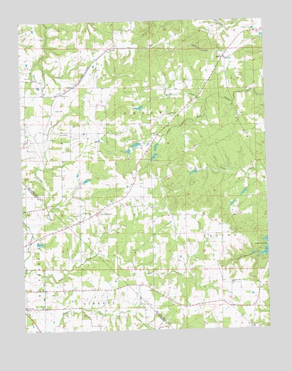
Sprott, MO USGS Topographic Map
Click on map above to begin viewing in our Map Viewer.

This topographic map contains these locations and features:
Feature Name Type Latitude Longitude GNIS ID View Map
Burks School (historical)SchoolN37.8409°W90.3332°737637View Map
Busiek SchoolSchoolN37.7598°W90.3743°755836View Map
Camp CreekStreamN37.7923°W90.3718°755848View Map
Chestnut RidgePopulated PlaceN37.7981°W90.3365°737641View Map
Chestnut Ridge Baptist ChurchChurchN37.7976°W90.3368°737642View Map
Chestnut Ridge CemeteryCemeteryN37.7965°W90.3407°715774View Map
Chestnut Ridge SchoolSchoolN37.7973°W90.3357°715775View Map
Doss CemeteryCemeteryN37.8528°W90.3726°716995View Map
Genevieve ChurchChurchN37.8370°W90.2985°736299View Map
Hart LakeReservoirN37.8399°W90.3143°764112View Map
Henry HollowValleyN37.7806°W90.2582°737643View Map
Hintze Lake DamDamN37.8701°W90.3301°764668View Map
JoncaPopulated PlaceN37.8373°W90.2990°739953View Map
Jonca School (historical)SchoolN37.8420°W90.2868°737638View Map
Kaeppel Lake DamDamN37.8401°W90.3135°764111View Map
Kimmel LakeReservoirN37.8284°W90.3185°764108View Map
Kimmel Lake DamDamN37.8284°W90.3185°764107View Map
Lake GenevieveReservoirN37.8249°W90.3165°764326View Map
Lake Genevieve Lower DamDamN37.8251°W90.3151°764325View Map
Madison School (historical)SchoolN37.7601°W90.2823°737639View Map
Mc Clintock CemeteryCemeteryN37.8136°W90.3544°722045View Map
Mc Gee CemeteryCemeteryN37.8454°W90.3516°722106View Map
MillersPopulated PlaceN37.8606°W90.2704°741068View Map
Monahan LakeReservoirN37.7854°W90.3666°763978View Map
Mononame 212 DamDamN37.8017°W90.2668°764106View Map
Mononame 613 DamDamN37.8701°W90.3218°764667View Map
Moynihan Lake DamDamN37.7851°W90.3685°763977View Map
Murphy CemeteryCemeteryN37.8394°W90.3571°723072View Map
North Fork Jonca CreekStreamN37.8426°W90.2796°723460View Map
Oakland CemeteryCemeteryN37.8297°W90.3510°723663View Map
PickelPopulated PlaceN37.7964°W90.2868°739954View Map
Pickle Springs Double ArchArchN37.8033°W90.2978°2680498View Map
Pineview DamDamN37.8217°W90.3068°764323View Map
Pineview LakeReservoirN37.8201°W90.3072°764324View Map
Pleasant Hill CemeteryCemeteryN37.7692°W90.2695°2703047View Map
Pleasant Hill ChurchChurchN37.7689°W90.2685°736336View Map
Ponca Post Office (historical)Post OfficeN37.8601°W90.2698°760149View Map
Rudy CemeteryCemeteryN37.7969°W90.3460°725657View Map
Sainte Genevieve Sportsman Club Lake DamDamN37.8101°W90.3435°764109View Map
Sand CreekStreamN37.7742°W90.3735°756688View Map
Schaefer Lake DamDamN37.8451°W90.3168°764327View Map
South Fork Jonca CreekStreamN37.8426°W90.2793°726743View Map
Spring Hart Lake DamDamN37.8067°W90.2601°764481View Map
SprottPopulated PlaceN37.8639°W90.3285°726967View Map
Taylor BranchStreamN37.7923°W90.3721°756785View Map
Tragden LakeReservoirN37.8108°W90.3418°764110View Map
Trautman LakeReservoirN37.8551°W90.2985°764863View Map
Trautman Lake DamDamN37.8551°W90.2985°764862View Map
Unity School (historical)SchoolN37.7598°W90.3651°757923View Map
Valley Forge (historical)Populated PlaceN37.7853°W90.3735°757407View Map
Valley Forge School (historical)SchoolN37.7901°W90.3740°757922View Map

Note: Coordinates in the location and feature list above are referenced to NAD83 datum.


Copyright (C) 2008-2024 Ryan Niemi / Sunset Dynamics ... All Rights Reserved