TopoQuest Logo
Do you find TopoQuest useful?
Help keep TopoQuest running and adding new maps/features by donating!
Bitcoin:  19c7KJd3qBynnjoSw5npx9KScwjBe4ifkT
Litecoin:  LXs6TkuXGGXo1vDsWCkWVdjQX94eUKd6ui
Home View Maps Find Maps Find Places Resources & Links


Gilbert, Minnesota Topographic Map

USGS Map Title: Gilbert, MN
USGS Map MRC: 47092D4
DRG (GeoTIFF) Download: o47092d4.tif


Neighboring USGS Topographic Map Quads:


  Virginia, MN  
47092E5
 

  McKinley, MN  
47092E4
 

  Biwabik, MN  
47092E3
 

  Eveleth, MN  
47092D5
 

  Gilbert, MN  
47092D4
 

  Palo, MN  
47092D3
 

  Zim, MN  
47092C5
 

  Central Lakes, MN  
47092C4
 

  Makinen, MN  
47092C3


Map MRC Location:

N48°
W93°
N48°
W92°
H8 H7 H6 H5 H4 H3 H2 H1
G8 G7 G6 G5 G4 G3 G2 G1
F8 F7 F6 F5 F4 F3 F2 F1
E8 E7 E6 E5 E4 E3 E2 E1
D8 D7 D6 D5 D4 D3 D2 D1
C8 C7 C6 C5 C4 C3 C2 C1
B8 B7 B6 B5 B4 B3 B2 B1
A8 A7 A6 A5 A4 A3 A2 A1
N47°
W93°
N47°
W92°

Gilbert, MN USGS 1:24K Topographic Map Preview:
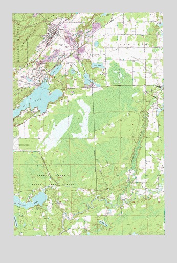
Gilbert, MN USGS Topographic Map
Click on map above to begin viewing in our Map Viewer.

This topographic map contains these locations and features:
Feature Name Type Latitude Longitude GNIS ID View Map
City of GilbertCivilN47.4910°W92.4617°2394893View Map
Deep LakeLakeN47.4680°W92.4640°661102View Map
Ely CreekStreamN47.3874°W92.4588°661207View Map
Ely LakeReservoirN47.4506°W92.4811°1775893View Map
Ely LakeLakeN47.4502°W92.4860°661209View Map
Ely Lake DamDamN47.4433°W92.4735°1775892View Map
Embarrass RiverStreamN47.3922°W92.4144°661216View Map
Esquagama LakeReservoirN47.4549°W92.3835°1776060View Map
Esquagama Lake DamDamN47.4549°W92.3835°1776059View Map
Eveleth Scout CampLocaleN47.3910°W92.4807°661236View Map
Evelth Junior High SchoolSchoolN47.4886°W92.4711°2126384View Map
Fayal Township State Game RefugeParkN47.4083°W92.4891°661255View Map
Genoa MineMineN47.4641°W92.4919°661348View Map
GilbertPopulated PlaceN47.4888°W92.4649°661356View Map
Gilbert CemeteryCemeteryN47.4811°W92.4786°661357View Map
Gilbert Community ChurchChurchN47.4892°W92.4681°2126385View Map
Gilbert Fire DepartmentBuildingN47.4869°W92.4673°2126383View Map
Gilbert MineMineN47.4821°W92.4566°661358View Map
Gilbert Police StationBuildingN47.4871°W92.4671°2126382View Map
Gilbert Post OfficePost OfficeN47.4889°W92.4647°2126380View Map
Gilbert Public LibraryBuildingN47.4889°W92.4647°2126381View Map
Gilbert StationLocaleN47.4947°W92.4617°2126379View Map
Gill LakeLakeN47.4671°W92.4503°661359View Map
Hay CreekStreamN47.3955°W92.4316°661440View Map
Heikkala LakeLakeN47.3816°W92.4260°661455View Map
Heritage Trail Bible ChurchChurchN47.4950°W92.4083°2126377View Map
Leaf LakeLakeN47.4704°W92.4299°661693View Map
Lost LakeLakeN47.4620°W92.4365°661822View Map
Old Apostolic Lutheran ChurchChurchN47.4653°W92.4775°2126378View Map
Pleasant LakeLakeN47.3922°W92.4907°662208View Map
Saint Josephs ChurchChurchN47.4858°W92.4719°2126386View Map
Schley MineMineN47.4813°W92.4555°662383View Map
Sky Harbor Seaplane BaseAirportN47.4594°W92.4766°660608View Map
SpartaPopulated PlaceN47.4674°W92.4774°662502View Map
Sparta Post Office (historical)Post OfficeN47.4675°W92.4772°2117777View Map
Sparta StationLocaleN47.4675°W92.4772°2117778View Map
Sparta-Matta MineMineN47.4716°W92.4777°662503View Map
Township of FayalCivilN47.4137°W92.4935°664152View Map

Note: Coordinates in the location and feature list above are referenced to NAD83 datum.


Copyright (C) 2008-2024 Ryan Niemi / Sunset Dynamics ... All Rights Reserved