TopoQuest Logo
Do you find TopoQuest useful?
Help keep TopoQuest running and adding new maps/features by donating!
Bitcoin:  19c7KJd3qBynnjoSw5npx9KScwjBe4ifkT
Litecoin:  LXs6TkuXGGXo1vDsWCkWVdjQX94eUKd6ui
Home View Maps Find Maps Find Places Resources & Links


Palo, Minnesota Topographic Map

USGS Map Title: Palo, MN
USGS Map MRC: 47092D3
DRG (GeoTIFF) Download: o47092d3.tif


Neighboring USGS Topographic Map Quads:


  McKinley, MN  
47092E4
 

  Biwabik, MN  
47092E3
 

  Aurora, MN  
47092E2
 

  Gilbert, MN  
47092D4
 

  Palo, MN  
47092D3
 

  Turpela Lake, MN  
47092D2
 

  Central Lakes, MN  
47092C4
 

  Makinen, MN  
47092C3
 

  Whiteface Reservoir, MN  
47092C2


Map MRC Location:

N48°
W93°
N48°
W92°
H8 H7 H6 H5 H4 H3 H2 H1
G8 G7 G6 G5 G4 G3 G2 G1
F8 F7 F6 F5 F4 F3 F2 F1
E8 E7 E6 E5 E4 E3 E2 E1
D8 D7 D6 D5 D4 D3 D2 D1
C8 C7 C6 C5 C4 C3 C2 C1
B8 B7 B6 B5 B4 B3 B2 B1
A8 A7 A6 A5 A4 A3 A2 A1
N47°
W93°
N47°
W92°

Palo, MN USGS 1:24K Topographic Map Preview:
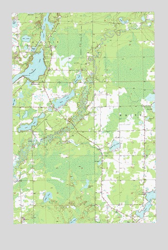
Palo, MN USGS Topographic Map
Click on map above to begin viewing in our Map Viewer.

This topographic map contains these locations and features:
Feature Name Type Latitude Longitude GNIS ID View Map
Bass LakeLakeN47.4481°W92.3305°660716View Map
Biwabik Township Police DepartmentBuildingN47.4737°W92.3728°2758647View Map
Biwabik Township Volunteer Fire DepartmentBuildingN47.4760°W92.3707°2666471View Map
Camp SigelLocaleN47.4710°W92.3468°660948View Map
Cedar Island LakeLakeN47.4966°W92.3444°660968View Map
Cedar LakeLakeN47.3909°W92.3449°660969View Map
Cedar LakeLakeN47.4947°W92.2773°660970View Map
Coe LakeLakeN47.3756°W92.3228°661022View Map
Esquagama ClubBuildingN47.4666°W92.3585°661228View Map
Esquagama LakeLakeN47.4670°W92.3561°661229View Map
Forge LakeLakeN47.4937°W92.3738°661304View Map
Four H CampLocaleN47.4741°W92.3466°661310View Map
Fourth LakeLakeN47.4783°W92.3557°661313View Map
Frying Pan LakeLakeN47.4210°W92.2855°661330View Map
Kahtava LakeLakeN47.4370°W92.2567°661611View Map
Lakeland Volunteer Fire DepartmentBuildingN47.4562°W92.3485°2666554View Map
Little Esquagama LakeLakeN47.4587°W92.3606°661738View Map
Loon LakeLakeN47.3880°W92.2543°661810View Map
Loon Lake SchoolSchoolN47.3927°W92.2599°661811View Map
Lost LakeLakeN47.4331°W92.3614°661821View Map
Mamrelund ChurchChurchN47.4583°W92.3613°647429View Map
North Twin LakeLakeN47.4491°W92.2530°662878View Map
PaloPopulated PlaceN47.4152°W92.2596°662129View Map
Palo Congregational ChurchChurchN47.4153°W92.2597°2126557View Map
Palo Post Office (historical)Post OfficeN47.4153°W92.2597°2126556View Map
Palo Regional Volunteer Fire DepartmentBuildingN47.4460°W92.2536°2126555View Map
Pot LakeLakeN47.4107°W92.2991°662223View Map
Rauha CemeteryCemeteryN47.4183°W92.2880°662261View Map
Round LakeLakeN47.4792°W92.3634°662307View Map
Saint Louis River HallLocaleN47.4008°W92.3749°662335View Map
Saint Marks Lutheran ChurchChurchN47.3842°W92.2603°2126433View Map
Salt LakeLakeN47.4847°W92.3628°662349View Map
Silver LakeLakeN47.4609°W92.3174°662449View Map
Silver LakeLakeN47.4472°W92.3741°662452View Map
Tikander LakeLakeN47.3980°W92.3110°662648View Map
Township of BiwabikCivilN47.4950°W92.3719°663605View Map
Twin LakesLakeN47.4493°W92.2532°662876View Map
Unorganized Territory of Tikander Lake (historical)CensusN47.4153°W92.3680°2393825View Map

Note: Coordinates in the location and feature list above are referenced to NAD83 datum.


Copyright (C) 2008-2024 Ryan Niemi / Sunset Dynamics ... All Rights Reserved