TopoQuest Logo
Do you find TopoQuest useful?
Help keep TopoQuest running and adding new maps/features by donating!
Bitcoin:  19c7KJd3qBynnjoSw5npx9KScwjBe4ifkT
Litecoin:  LXs6TkuXGGXo1vDsWCkWVdjQX94eUKd6ui
Home View Maps Find Maps Find Places Resources & Links


Goodhue West, Minnesota Topographic Map

USGS Map Title: Goodhue West, MN
USGS Map MRC: 44092D6
DRG (GeoTIFF) Download: o44092d6.tif


Neighboring USGS Topographic Map Quads:


  Miesville, MN  
44092E7
 

  Welch, MN  
44092E6
 

  Red Wing, MN  
44092E5
 

  White Rock, MN  
44092D7
 

  Goodhue West, MN  
44092D6
 

  Goodhue East, MN  
44092D5
 

  Wanamingo, MN  
44092C7
 

  Zumbrota, MN  
44092C6
 

  Mazeppa, MN  
44092C5


Map MRC Location:

N45°
W93°
N45°
W92°
H8 H7 H6 H5 H4 H3 H2 H1
G8 G7 G6 G5 G4 G3 G2 G1
F8 F7 F6 F5 F4 F3 F2 F1
E8 E7 E6 E5 E4 E3 E2 E1
D8 D7 D6 D5 D4 D3 D2 D1
C8 C7 C6 C5 C4 C3 C2 C1
B8 B7 B6 B5 B4 B3 B2 B1
A8 A7 A6 A5 A4 A3 A2 A1
N44°
W93°
N44°
W92°

Goodhue West, MN USGS 1:24K Topographic Map Preview:
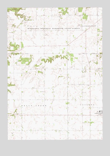
Goodhue West, MN USGS Topographic Map
Click on map above to begin viewing in our Map Viewer.

This topographic map contains these locations and features:
Feature Name Type Latitude Longitude GNIS ID View Map
Cecil Franklin DamDamN44.4950°W92.6452°1776621View Map
City of GoodhueCivilN44.4007°W92.6254°2394929View Map
ClaybankPopulated PlaceN44.4416°W92.6319°654645View Map
Claybank Post Office (historical)Post OfficeN44.4417°W92.6317°2064886View Map
Evergreen CemeteryCemeteryN44.3986°W92.6305°2065016View Map
Goodhue CountyCivilN44.4098°W92.7226°659470View Map
Goodhue Public SchoolsSchoolN44.4019°W92.6283°2064958View Map
Holy Trinity Catholic ChurchChurchN44.4011°W92.6267°2064957View Map
Hope CemeteryCemeteryN44.4830°W92.6369°645170View Map
RyanPopulated PlaceN44.4239°W92.7155°654921View Map
Ryan Post Office (historical)Post OfficeN44.4239°W92.7153°2064863View Map
Saint Columbkill's Catholic Church CemeteryCemeteryN44.4203°W92.7003°2064999View Map
Saint Columkills ChurchChurchN44.4205°W92.7021°650566View Map
Saint Luke's Lutheran ChurchChurchN44.3994°W92.6261°2064955View Map
Saint Peter's Lutheran ChurchChurchN44.4017°W92.6308°2064956View Map
Sodbuster StripAirportN44.4026°W92.6875°2717089View Map
Swedish CemeteryCemeteryN44.4200°W92.6507°652927View Map
Township of Belle CreekCivilN44.4129°W92.7308°663554View Map
Zion CemeteryCemeteryN44.4269°W92.6533°2065015View Map
Zion ChurchChurchN44.4269°W92.6535°654468View Map

Note: Coordinates in the location and feature list above are referenced to NAD83 datum.


Copyright (C) 2008-2024 Ryan Niemi / Sunset Dynamics ... All Rights Reserved