TopoQuest Logo
Do you find TopoQuest useful?
Help keep TopoQuest running and adding new maps/features by donating!
Bitcoin:  19c7KJd3qBynnjoSw5npx9KScwjBe4ifkT
Litecoin:  LXs6TkuXGGXo1vDsWCkWVdjQX94eUKd6ui
Home View Maps Find Maps Find Places Resources & Links


Atlanta, Michigan Topographic Map

USGS Map Title: Atlanta, MI
USGS Map MRC: 45084A2
DRG (GeoTIFF) Download: o45084a2.tif


Neighboring USGS Topographic Map Quads:


  Silver Lake, MI  
45084B3
 

  Lake Geneva, MI  
45084B2
 

  Cranberry Lake, MI  
45084B1
 

  Hetherton, MI  
45084A3
 

  Atlanta, MI  
45084A2
 

  Atlanta SE, MI  
45084A1
 

  Lewiston, MI  
44084H3
 

  Crooked Lake, MI  
44084H2
 

  Avery, MI  
44084H1


Map MRC Location:

N46°
W85°
N46°
W84°
H8 H7 H6 H5 H4 H3 H2 H1
G8 G7 G6 G5 G4 G3 G2 G1
F8 F7 F6 F5 F4 F3 F2 F1
E8 E7 E6 E5 E4 E3 E2 E1
D8 D7 D6 D5 D4 D3 D2 D1
C8 C7 C6 C5 C4 C3 C2 C1
B8 B7 B6 B5 B4 B3 B2 B1
A8 A7 A6 A5 A4 A3 A2 A1
N45°
W85°
N45°
W84°

Atlanta, MI USGS 1:24K Topographic Map Preview:
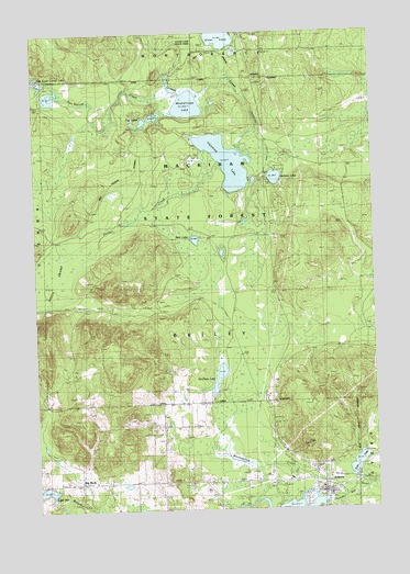
Atlanta, MI USGS Topographic Map
Click on map above to begin viewing in our Map Viewer.

This topographic map contains these locations and features:
Feature Name Type Latitude Longitude GNIS ID View Map
AtlantaPopulated PlaceN45.0047°W84.1439°620305View Map
Atlanta Bible ChurchChurchN45.0108°W84.1475°2438593View Map
Atlanta Census Designated PlaceCensusN45.0017°W84.1535°2393321View Map
Atlanta Congregational ChurchChurchN45.0050°W84.1453°2438595View Map
Atlanta Full Gospel AssemblyChurchN45.0069°W84.1583°2438594View Map
Atlanta Post OfficePost OfficeN45.0033°W84.1431°2438576View Map
Atlanta Public LibraryBuildingN45.0083°W84.1553°2438574View Map
Atlanta Station (historical)LocaleN45.0089°W84.1444°2438563View Map
Bear LakeLakeN45.0708°W84.1909°620861View Map
Big RockLocaleN45.0075°W84.2347°621347View Map
Big Rock Congregational ChurchChurchN45.0075°W84.2292°2438611View Map
Big Rock Historical MarkerParkN45.0069°W84.2342°2438610View Map
Big Rock Post Office (historical)Post OfficeN45.0075°W84.2347°2438570View Map
Briley CemeteryCemeteryN45.0089°W84.1708°621996View Map
Church of ChristChurchN45.0100°W84.1461°2438592View Map
Clear LakeLakeN45.1248°W84.1802°623432View Map
De Cheau LakeLakeN45.0346°W84.1827°1618837View Map
East Town Corner LakeLakeN45.1128°W84.2483°625265View Map
Elk Ridge Golf CourseLocaleN45.0917°W84.1858°2438575View Map
Haymeadow CreekStreamN45.0083°W84.1358°627998View Map
Jackson LakeLakeN45.0869°W84.1610°629172View Map
Jackson Lake State Forest CampgroundLocaleN45.0892°W84.1603°2438531View Map
Kingdom Hall of Jehovah's WitnessesChurchN45.0078°W84.1486°2438596View Map
Lake InezLakeN45.0052°W84.2467°638511View Map
Michigan Department of Natural Resources Atlanta Forest AreaBuildingN45.0327°W84.1629°2627013View Map
Montmorency CountyCivilN45.0275°W84.1272°1623002View Map
Montmorency County CourthouseBuildingN45.0042°W84.1439°2438590View Map
Montmorency County FairgroundsLocaleN45.0297°W84.1661°2438589View Map
Montmorency County Sheriff's OfficeBuildingN45.0066°W84.1723°2438573View Map
Muskellunge LakeLakeN45.1059°W84.1924°633168View Map
Northern Michigan Restoration Branch ChurchChurchN45.0150°W84.1589°2438597View Map
Packer CreekStreamN45.0914°W84.1820°634285View Map
Pug LakesLakeN45.1033°W84.2064°635504View Map
Saint Marks Episcopal ChurchChurchN45.0128°W84.1517°2438591View Map
Township of BrileyCivilN45.0280°W84.1890°1625983View Map
Tri - Township Ambulance ServiceBuildingN45.0057°W84.1458°2662022View Map
Tri - Township Fire DepartmentBuildingN45.0049°W84.1445°2626944View Map
Twin LakeLakeN45.0115°W84.1320°1615246View Map
Valentine LakeLakeN45.0913°W84.1785°1615442View Map
Valentine Lake Station (historical)LocaleN45.0967°W84.1308°2438555View Map
Valentine Post Office (historical)Post OfficeN45.0967°W84.1308°2438554View Map
Van Hetton CreekStreamN45.1097°W84.1986°1615474View Map

Note: Coordinates in the location and feature list above are referenced to NAD83 datum.


Copyright (C) 2008-2024 Ryan Niemi / Sunset Dynamics ... All Rights Reserved