TopoQuest Logo
Do you find TopoQuest useful?
Help keep TopoQuest running and adding new maps/features by donating!
Bitcoin:  19c7KJd3qBynnjoSw5npx9KScwjBe4ifkT
Litecoin:  LXs6TkuXGGXo1vDsWCkWVdjQX94eUKd6ui
Home View Maps Find Maps Find Places Resources & Links


Gray Summit, Missouri Topographic Map

USGS Map Title: Gray Summit, MO
USGS Map MRC: 38090D7
DRG (GeoTIFF) Download: o38090d7.tif


Neighboring USGS Topographic Map Quads:


  Washington East, MO  
38090E8
 

  Labadie, MO  
38090E7
 

  Eureka, MO  
38090E6
 

  Moselle, MO  
38090D8
 

  Gray Summit, MO  
38090D7
 

  Pacific, MO  
38090D6
 

  Saint Clair, MO  
38090C8
 

  Lonedell, MO  
38090C7
 

  Cedar Hill, MO  
38090C6


Map MRC Location:

N39°
W91°
N39°
W90°
H8 H7 H6 H5 H4 H3 H2 H1
G8 G7 G6 G5 G4 G3 G2 G1
F8 F7 F6 F5 F4 F3 F2 F1
E8 E7 E6 E5 E4 E3 E2 E1
D8 D7 D6 D5 D4 D3 D2 D1
C8 C7 C6 C5 C4 C3 C2 C1
B8 B7 B6 B5 B4 B3 B2 B1
A8 A7 A6 A5 A4 A3 A2 A1
N38°
W91°
N38°
W90°

Gray Summit, MO USGS 1:24K Topographic Map Preview:
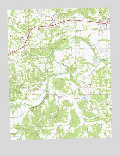
Gray Summit, MO USGS Topographic Map
Click on map above to begin viewing in our Map Viewer.

This topographic map contains these locations and features:
Feature Name Type Latitude Longitude GNIS ID View Map
Bend SchoolSchoolN38.4539°W90.7896°741667View Map
Boles Fire Protection District Station 1BuildingN38.4884°W90.8180°2621274View Map
Brady CreekStreamN38.3856°W90.7793°714621View Map
Brush Creek CemeteryCemeteryN38.4823°W90.8387°714866View Map
Buckner DamDamN38.4367°W90.7685°765262View Map
Calvey CreekStreamN38.4384°W90.8012°731545View Map
CatawissaPopulated PlaceN38.4248°W90.7826°715491View Map
Catawissa Post OfficePost OfficeN38.4230°W90.7819°2782862View Map
Catawissa SchoolSchoolN38.4245°W90.7674°715493View Map
Cedar Grove ChurchChurchN38.4267°W90.8626°731553View Map
Cedar Grove SchoolSchoolN38.4264°W90.8646°741666View Map
City of PacificCivilN38.4805°W90.7543°2396123View Map
Coleman CemeteryCemeteryN38.4967°W90.8537°716107View Map
Coleman Elementary SchoolSchoolN38.4810°W90.8513°716114View Map
Evergreen Lake Upper DamDamN38.4151°W90.7501°764894View Map
Evergreen LakesReservoirN38.4159°W90.7502°717692View Map
Evergreen Lakes Lower DamDamN38.4151°W90.7501°764895View Map
Frisco Heights School (historical)SchoolN38.3989°W90.8535°730617View Map
G Gundaker DamDamN38.4701°W90.8318°764369View Map
Good CemeteryCemeteryN38.4370°W90.8418°718550View Map
Gray SummitPopulated PlaceN38.4898°W90.8168°731576View Map
Gray Summit Census Designated PlaceCensusN38.4951°W90.8173°2393025View Map
Gray Summit Post OfficePost OfficeN38.4895°W90.8168°2782701View Map
Hazelrun - Rose Hill CemeteryCemeteryN38.4556°W90.8596°719304View Map
High Meadow Lake DamDamN38.4101°W90.8201°764636View Map
Interchange 257CrossingN38.4850°W90.7594°2468219View Map
Johns Lake DamDamN38.4351°W90.7851°765265View Map
Johnson Lake DamDamN38.4417°W90.7801°765264View Map
Kober LakeReservoirN38.4484°W90.8051°764601View Map
Lake SereneReservoirN38.4133°W90.7827°758338View Map
Lake Serene DamDamN38.4117°W90.7851°764368View Map
Leo Politte and John Lynch LakeReservoirN38.4093°W90.8202°764637View Map
Little Calvey CreekStreamN38.4064°W90.7976°721182View Map
McAdams Lake DamDamN38.3801°W90.8135°765489View Map
Meramec TerracePopulated PlaceN38.4159°W90.8301°730618View Map
Missouri Botanical Garden ArboretumParkN38.4714°W90.8157°731620View Map
Missouri Botanical Gardens Lake DamDamN38.4767°W90.8251°764364View Map
Mitchell CemeteryCemeteryN38.4112°W90.8029°722487View Map
Mount Calvary ChurchChurchN38.3967°W90.8210°722723View Map
New Saint Bridgets CemeteryCemeteryN38.4887°W90.7548°723296View Map
Nike Junior High SchoolSchoolN38.4078°W90.7532°723374View Map
North CemeteryCemeteryN38.4803°W90.8382°723438View Map
Oak Ridge CemeteryCemeteryN38.4017°W90.7673°723635View Map
Old Hazelrun CemeteryCemeteryN38.4575°W90.8518°723755View Map
Old Saint Bridgets CemeteryCemeteryN38.4903°W90.7548°723780View Map
Pacific CemeteryCemeteryN38.4887°W90.7537°723949View Map
Pacific Fire Protection District Station 1BuildingN38.4837°W90.7519°2621073View Map
Pacific Fire Protection District Station 2BuildingN38.4156°W90.8165°2620832View Map
Pacific Fishing Lake DamDamN38.4484°W90.8051°764600View Map
Pacific Police DepartmentBuildingN38.4857°W90.7699°2752327View Map
Pleasant Valley School (historical)SchoolN38.3956°W90.7632°741669View Map
PraterPopulated PlaceN38.4495°W90.7599°740012View Map
Purina FarmLocaleN38.4956°W90.8362°741665View Map
Roberts CemeteryCemeteryN38.4325°W90.8120°725400View Map
Roberts CemeteryCemeteryN38.4739°W90.8137°725401View Map
RobertsvillePopulated PlaceN38.4148°W90.8140°731638View Map
Robertsville Post OfficePost OfficeN38.4151°W90.8108°2782726View Map
Robertsville SchoolSchoolN38.4123°W90.8143°730619View Map
Rose Hill ChurchChurchN38.4556°W90.8496°725568View Map
Seyer LakeReservoirN38.4367°W90.7685°765263View Map
Shaw S Garden LakeReservoirN38.4767°W90.8251°764365View Map
Shiloh CemeteryCemeteryN38.4160°W90.8095°726362View Map
Strothmann Lake DamDamN38.3934°W90.8301°765266View Map
Sunset Memorial CemeteryCemeteryN38.4878°W90.7556°727331View Map
The DiamondsPopulated PlaceN38.4731°W90.8568°737976View Map
Thompson CemeteryCemeteryN38.4256°W90.8251°727599View Map
Tiler CemeteryCemeteryN38.4751°W90.8372°727656View Map
Township of CalveyCivilN38.3870°W90.8074°766646View Map
Watson Lake DamDamN38.4301°W90.7701°764670View Map
Winch CreekStreamN38.4451°W90.7549°728988View Map
Woodland Hills Subdivision Lake DamDamN38.3851°W90.8118°765488View Map
Woodland SchoolSchoolN38.3873°W90.8162°741668View Map
Woods CreekStreamN38.4156°W90.8312°729123View Map

Note: Coordinates in the location and feature list above are referenced to NAD83 datum.


Copyright (C) 2008-2024 Ryan Niemi / Sunset Dynamics ... All Rights Reserved