TopoQuest Logo
Do you find TopoQuest useful?
Help keep TopoQuest running and adding new maps/features by donating!
Bitcoin:  19c7KJd3qBynnjoSw5npx9KScwjBe4ifkT
Litecoin:  LXs6TkuXGGXo1vDsWCkWVdjQX94eUKd6ui
Home View Maps Find Maps Find Places Resources & Links


Greenfield Bend, Tennessee Topographic Map

USGS Map Title: Greenfield Bend, TN
USGS Map MRC: 35087F3
DRG (GeoTIFF) Download: o35087f3.tif


Neighboring USGS Topographic Map Quads:


  Centerville, TN  
35087G4
 

  Littlelot, TN  
35087G3
 

  Primm Springs, TN  
35087G2
 

  Sunrise, TN  
35087F4
 

  Greenfield Bend, TN  
35087F3
 

  Williamsport, TN  
35087F2
 

  Gordonsburg, TN  
35087E4
 

  Mount Joy, TN  
35087E3
 

  Mount Pleasant, TN  
35087E2


Map MRC Location:

N36°
W88°
N36°
W87°
H8 H7 H6 H5 H4 H3 H2 H1
G8 G7 G6 G5 G4 G3 G2 G1
F8 F7 F6 F5 F4 F3 F2 F1
E8 E7 E6 E5 E4 E3 E2 E1
D8 D7 D6 D5 D4 D3 D2 D1
C8 C7 C6 C5 C4 C3 C2 C1
B8 B7 B6 B5 B4 B3 B2 B1
A8 A7 A6 A5 A4 A3 A2 A1
N35°
W88°
N35°
W87°

Greenfield Bend, TN USGS 1:24K Topographic Map Preview:
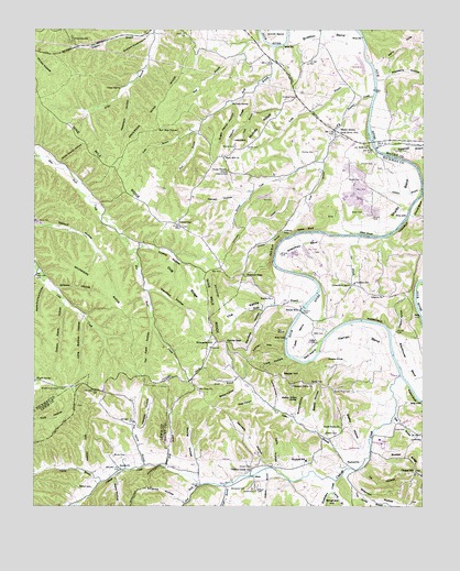
Greenfield Bend, TN USGS Topographic Map
Click on map above to begin viewing in our Map Viewer.

This topographic map contains these locations and features:
Feature Name Type Latitude Longitude GNIS ID View Map
Air Rock ChurchChurchN35.7195°W87.2675°1275511View Map
Air Rock School (historical)SchoolN35.7195°W87.2672°1319040View Map
American HollowValleyN35.6266°W87.3278°1275657View Map
Anderson Bend RidgeRidgeN35.7340°W87.3328°1275680View Map
Apple Orchard HollowValleyN35.6828°W87.3714°1275825View Map
Bailey HollowValleyN35.6559°W87.3085°1276111View Map
Baker BluffCliffN35.6970°W87.2883°1276134View Map
Baker CemeteryCemeteryN35.7017°W87.2694°1276151View Map
Baker CemeteryCemeteryN35.7106°W87.2742°1276152View Map
Baker SloughStreamN35.6959°W87.2653°1276190View Map
Baxter CemeteryCemeteryN35.6570°W87.2856°1276508View Map
Baxter HillSummitN35.6587°W87.2947°1276511View Map
Beard HollowValleyN35.6452°W87.2842°1276641View Map
Bethel ChurchChurchN35.6348°W87.3470°1305132View Map
Bethel SchoolSchoolN35.6298°W87.3564°1277137View Map
Bingham CemeteryCemeteryN35.7320°W87.2914°1277483View Map
Boat BranchStreamN35.7498°W87.3039°1277852View Map
Booker RidgeRidgeN35.6381°W87.2553°1277969View Map
Bratton BendBendN35.7476°W87.2825°1278251View Map
Brickhouse BendBendN35.6623°W87.2508°1305410View Map
Brown CemeteryCemeteryN35.6378°W87.3492°1278533View Map
Buck BranchStreamN35.7453°W87.2981°1278791View Map
Bullock HollowValleyN35.6486°W87.2909°1278970View Map
Bullock Hollow SpringSpringN35.6534°W87.2903°1278971View Map
Buzzard Roost HollowValleyN35.7481°W87.3387°1279229View Map
Catheys CemeteryCemeteryN35.6434°W87.2811°1279898View Map
Catheys CreekStreamN35.6590°W87.2570°1305731View Map
Catheys Creek ChurchChurchN35.6342°W87.3047°1305732View Map
Cave BranchStreamN35.7351°W87.3045°1279915View Map
Cave Spring BranchStreamN35.6348°W87.2736°1303424View Map
Center StarPopulated PlaceN35.6984°W87.3286°1280148View Map
Center Star CemeteryCemeteryN35.6987°W87.3275°1319055View Map
Center Star ChurchChurchN35.6984°W87.3281°1319056View Map
Center Star School (historical)SchoolN35.6981°W87.3275°1319057View Map
Chapel HillPopulated PlaceN35.6337°W87.2517°1280249View Map
Chapel Hill School (historical)SchoolN35.6334°W87.2539°1323675View Map
Cherry CemeteryCemeteryN35.6759°W87.2533°1646167View Map
Church BluffCliffN35.7031°W87.2517°1280545View Map
Church CemeteryCemeteryN35.7148°W87.2703°1323610View Map
Church CemeteryCemeteryN35.7187°W87.2594°1323677View Map
Clayton HollowValleyN35.6712°W87.2590°1280640View Map
Cotton Patch HollowValleyN35.6778°W87.3651°1281364View Map
Curry BranchStreamN35.6284°W87.2789°1281891View Map
Dale BranchStreamN35.6487°W87.2589°1281966View Map
Delk BendBendN35.6720°W87.2864°1282315View Map
Delk BluffCliffN35.6923°W87.2981°1282316View Map
Delk CemeteryCemeteryN35.6701°W87.2817°1282317View Map
Delk FordCrossingN35.6653°W87.2836°1313218View Map
Delk HollowValleyN35.6353°W87.2952°1282320View Map
Delk IslandIslandN35.6645°W87.2861°1282321View Map
Dobbins BranchStreamN35.6345°W87.3006°1282531View Map
Dog RidgeRidgeN35.6853°W87.3303°1282595View Map
Dry ForkStreamN35.6306°W87.3211°1282962View Map
Duck River Post OfficePost OfficeN35.7229°W87.2781°2773515View Map
Duck River Post Office (historical)Post OfficeN35.7237°W87.2786°1311348View Map
Dunlan CemeteryCemeteryN35.7176°W87.2847°1283186View Map
Dunlap CreekStreamN35.7323°W87.2664°1283192View Map
Far Field HollowValleyN35.6719°W87.3371°1284127View Map
Fattybread BranchStreamN35.7173°W87.2617°1306439View Map
Federson HollowValleyN35.7339°W87.3452°1284186View Map
Ferry Hill HollowValleyN35.7495°W87.2698°1311350View Map
Forty Thicket SchoolSchoolN35.7128°W87.3133°1284685View Map
Fuller BranchStreamN35.7231°W87.3233°1285016View Map
Gid HollowValleyN35.6747°W87.3114°1285360View Map
Gin BranchStreamN35.6956°W87.2708°1285440View Map
Gordon Ferry (historical)CrossingN35.7176°W87.2625°1646243View Map
Gordon Ferry BridgeBridgeN35.7187°W87.2656°1306499View Map
Graham SchoolSchoolN35.6834°W87.2722°1285808View Map
Greenfield BendPopulated PlaceN35.6828°W87.2731°1286166View Map
Greenfield BendBendN35.6912°W87.2867°1306516View Map
Greenfield Bend Church of ChristChurchN35.6834°W87.2725°1646245View Map
Half Way GroundFlatN35.7237°W87.3356°1286545View Map
Hampshire CreekStreamN35.6317°W87.2778°1269619View Map
Harlan BendBendN35.6665°W87.2711°1286876View Map
Harvell HollowValleyN35.7046°W87.3081°1287066View Map
Hensley HollowValleyN35.6448°W87.3408°1287468View Map
Hicks BluffCliffN35.6981°W87.2570°1287640View Map
Hoover GapGapN35.6856°W87.3081°1288273View Map
Hopkins CemeteryCemeteryN35.6920°W87.2853°1646270View Map
Irvin BranchStreamN35.7162°W87.2822°1289054View Map
IsomPopulated PlaceN35.6328°W87.3045°1306609View Map
Ivy HollowValleyN35.6347°W87.2697°1306611View Map
Ivy PointSummitN35.6703°W87.2975°1289133View Map
Jackson BranchStreamN35.6953°W87.2942°1269682View Map
Jackson FallsFallsN35.6967°W87.2956°1289216View Map
Jones BranchStreamN35.6584°W87.3097°1289694View Map
Jones CemeteryCemeteryN35.6287°W87.3042°1289722View Map
Jones Presbyterian Church (historical)ChurchN35.6292°W87.3039°1646292View Map
Keg Spring BranchStreamN35.6353°W87.3392°1289971View Map
Kellum RidgeRidgeN35.7253°W87.3106°1290022View Map
Kennedy HollowValleyN35.6357°W87.3016°1290076View Map
Kettle BranchStreamN35.6778°W87.2881°1290112View Map
Kettle ChurchChurchN35.6792°W87.2986°1290113View Map
Kettle GapGapN35.6678°W87.3136°1290115View Map
Kettle MillsPopulated PlaceN35.6762°W87.2897°1290119View Map
Kincade HillSummitN35.6665°W87.3183°1290176View Map
Kittrell CemeteryCemeteryN35.6353°W87.3047°1306651View Map
Kittrell CemeteryCemeteryN35.6292°W87.3033°1290332View Map
Lawson BranchStreamN35.7081°W87.2506°1290800View Map
Liberty ChurchChurchN35.6801°W87.2628°1291129View Map
Long Bottom HollowValleyN35.6743°W87.3593°1291863View Map
Love CemeteryCemeteryN35.6448°W87.2589°1306707View Map
Love HollowValleyN35.6641°W87.2932°1292124View Map
Love HollowValleyN35.7120°W87.2507°1292125View Map
Loves BranchStreamN35.6345°W87.2745°1292156View Map
LovetownPopulated PlaceN35.6437°W87.2511°1315440View Map
Lusk BranchStreamN35.6306°W87.3131°1292295View Map
Lyman HillSummitN35.6673°W87.3017°1292331View Map
Maple SpringPopulated PlaceN35.6576°W87.3742°1314268View Map
Mars Hill ChurchChurchN35.7167°W87.3142°1292739View Map
Mayberry HollowValleyN35.7370°W87.2628°1293006View Map
McCaleb SpringSpringN35.7305°W87.3120°1293098View Map
Mobley CemeteryCemeteryN35.7192°W87.3108°1294125View Map
Mobley RidgeRidgeN35.7245°W87.3028°1294129View Map
Morrow CemeteryCemeteryN35.6609°W87.3050°1646467View Map
Negro HillSummitN35.6298°W87.2570°1313517View Map
Nine Mile RidgeRidgeN35.7040°W87.3392°1295761View Map
Old Cathey CemeteryCemeteryN35.6462°W87.2669°1646489View Map
Old Love CemeteryCemeteryN35.6626°W87.3103°1646490View Map
Old Well CemeteryCemeteryN35.6801°W87.3131°1319119View Map
Orton SpringSpringN35.7348°W87.3473°1296498View Map
Peddler BluffCliffN35.6734°W87.2650°1297101View Map
Peery HollowValleyN35.6328°W87.3492°1297118View Map
Pipkin BluffCliffN35.6526°W87.2514°1297697View Map
Pleasant Union ChurchChurchN35.6565°W87.2922°1297929View Map
Pleasant Union School (historical)SchoolN35.6648°W87.3103°1324878View Map
Potato KnobSummitN35.6628°W87.2814°1298337View Map
Robeson BranchStreamN35.7490°W87.3375°1299678View Map
Saunders RidgeRidgeN35.6828°W87.3536°1300812View Map
Scott BranchStreamN35.6353°W87.3328°1300922View Map
Shady GrovePopulated PlaceN35.7237°W87.2786°1301184View Map
Shady Grove School (historical)SchoolN35.7253°W87.2778°1319128View Map
Shady Grove Volunteer Fire DepartmentBuildingN35.7228°W87.2774°2653886View Map
Shannon HollowValleyN35.6331°W87.2745°1301235View Map
She Boss ChurchChurchN35.6570°W87.3242°1303551View Map
Sheboss CemeteryCemeteryN35.6578°W87.3245°1324895View Map
Sheboss PlaceLocaleN35.6576°W87.3250°1324896View Map
Shelby BendBendN35.7070°W87.2642°1269980View Map
Shelby HollowValleyN35.6407°W87.2705°1269988View Map
Skipper HollowValleyN35.6820°W87.3674°1270445View Map
Smith CemeteryCemeteryN35.7192°W87.3072°1270612View Map
South Point CemeteryCemeteryN35.6545°W87.2786°1270905View Map
South Point ChurchChurchN35.6453°W87.2764°1270906View Map
Standfield HollowValleyN35.6766°W87.3011°1271215View Map
Stanfield HollowValleyN35.6816°W87.3389°1303794View Map
Stephens SchoolSchoolN35.6367°W87.2875°1303826View Map
Still HollowValleyN35.6350°W87.3583°1271391View Map
Strong HollowValleyN35.6336°W87.3220°1271606View Map
Sugar Camp HollowValleyN35.7311°W87.3112°1271647View Map
Tatum BranchStreamN35.6312°W87.3533°1304012View Map
TaylorsvillePopulated PlaceN35.6359°W87.2742°1314382View Map
Terrell HollowValleyN35.6513°W87.2974°1272334View Map
The HairpinLocaleN35.7473°W87.3628°1272397View Map
The KettleValleyN35.6789°W87.2930°1272406View Map
Tinsley HollowValleyN35.6924°W87.3426°1304115View Map
Tolly BranchStreamN35.7317°W87.2700°1272737View Map
Totty BranchStreamN35.7306°W87.2700°1311378View Map
Union Church (historical)ChurchN35.7151°W87.3664°1319142View Map
Union Church HollowValleyN35.7151°W87.3668°1273212View Map
Voss HollowValleyN35.6523°W87.3047°1273499View Map
Weatherly Lookout TowerTowerN35.6556°W87.3650°1647757View Map
Well CemeteryCemeteryN35.6867°W87.3150°1274090View Map
Whiteside CemeteryCemeteryN35.6292°W87.3070°1304560View Map
Whiteside CemeteryCemeteryN35.6403°W87.3403°1309499View Map
Whitfield CemeteryCemeteryN35.6515°W87.3611°1309498View Map

Note: Coordinates in the location and feature list above are referenced to NAD83 datum.


Copyright (C) 2008-2024 Ryan Niemi / Sunset Dynamics ... All Rights Reserved