TopoQuest Logo
Do you find TopoQuest useful?
Help keep TopoQuest running and adding new maps/features by donating!
Bitcoin:  19c7KJd3qBynnjoSw5npx9KScwjBe4ifkT
Litecoin:  LXs6TkuXGGXo1vDsWCkWVdjQX94eUKd6ui
Home View Maps Find Maps Find Places Resources & Links


Herndon, Kentucky Topographic Map

USGS Map Title: Herndon, KY
USGS Map MRC: 36087F5
DRG (GeoTIFF) Download: o36087f5.tif


Neighboring USGS Topographic Map Quads:


  Caledonia, KY  
36087G6
 

  Church Hill, KY  
36087G5
 

  Hopkinsville, KY  
36087G4
 

  Roaring Spring, KY  
36087F6
 

  Herndon, KY  
36087F5
 

  Oak Grove, KY  
36087F4
 

  Indian Mound, TN  
36087E6
 

  Woodlawn, TN  
36087E5
 

  New Providence, TN  
36087E4


Map MRC Location:

N37°
W88°
N37°
W87°
H8 H7 H6 H5 H4 H3 H2 H1
G8 G7 G6 G5 G4 G3 G2 G1
F8 F7 F6 F5 F4 F3 F2 F1
E8 E7 E6 E5 E4 E3 E2 E1
D8 D7 D6 D5 D4 D3 D2 D1
C8 C7 C6 C5 C4 C3 C2 C1
B8 B7 B6 B5 B4 B3 B2 B1
A8 A7 A6 A5 A4 A3 A2 A1
N36°
W88°
N36°
W87°

Herndon, KY USGS 1:24K Topographic Map Preview:
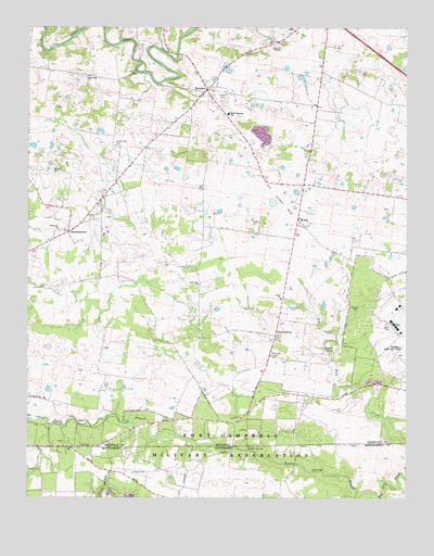
Herndon, KY USGS Topographic Map
Click on map above to begin viewing in our Map Viewer.

This topographic map contains these locations and features:
Feature Name Type Latitude Longitude GNIS ID View Map
BennettstownPopulated PlaceN36.6956°W87.6114°486867View Map
Campbell Army Airfield (Fort Campbell)AirportN36.6712°W87.5029°517377View Map
Double Barn CemeteryCemeteryN36.7187°W87.5953°491038View Map
Douglas (historical)Populated PlaceN36.6885°W87.5185°2742883View Map
Flat Lick (historical)Populated PlaceN36.7463°W87.5428°2742887View Map
Flat Lick ChurchChurchN36.7464°W87.5450°492200View Map
Fort Campbell Department of Defense Fire Department Station 4BuildingN36.6745°W87.5049°2637357View Map
Fort Campbell DivisionCivilN36.6626°W87.5008°1937006View Map
Fox CemeteryCemeteryN36.7023°W87.5378°492400View Map
GarrettsburgPopulated PlaceN36.6687°W87.5428°508071View Map
Garrott CemeteryCemeteryN36.6748°W87.5167°492733View Map
HerndonPopulated PlaceN36.7337°W87.5653°494087View Map
Herndon Volunteer Fire DepartmentBuildingN36.7348°W87.5637°2636931View Map
HowelPopulated PlaceN36.6992°W87.5356°494689View Map
LaFayettePopulated PlaceN36.6812°W87.6203°508413View Map
LaFayette DivisionCivilN36.7355°W87.5811°1937094View Map
Major CemeteryCemeteryN36.7325°W87.5611°497462View Map
McGee CemeteryCemeteryN36.7128°W87.6167°497858View Map
McKenzie-Kirk Presbyterian Church (historical)ChurchN36.6964°W87.6149°497901View Map
McKnight CemeteryCemeteryN36.6623°W87.5428°497920View Map
New Asia ChurchChurchN36.6817°W87.5681°499276View Map
Noahs SpringSpringN36.6387°W87.5525°1295792View Map
Olivet Baptist ChurchChurchN36.6781°W87.5419°499935View Map
Quarles SpringSpringN36.6639°W87.5242°2742904View Map
South Christian Elementary SchoolSchoolN36.7265°W87.5584°503899View Map
StephensonPopulated PlaceN36.7049°W87.6000°2742906View Map
Zion Hope ChurchChurchN36.7373°W87.6050°507299View Map

Note: Coordinates in the location and feature list above are referenced to NAD83 datum.


Copyright (C) 2008-2024 Ryan Niemi / Sunset Dynamics ... All Rights Reserved