TopoQuest Logo
Do you find TopoQuest useful?
Help keep TopoQuest running and adding new maps/features by donating!
Bitcoin:  19c7KJd3qBynnjoSw5npx9KScwjBe4ifkT
Litecoin:  LXs6TkuXGGXo1vDsWCkWVdjQX94eUKd6ui
Home View Maps Find Maps Find Places Resources & Links


Hollytree, Alabama Topographic Map

USGS Map Title: Hollytree, AL
USGS Map MRC: 34086G3
DRG (GeoTIFF) Download: o34086g3.tif


Neighboring USGS Topographic Map Quads:


  New Market, AL  
34086H4
 

  King Cove, AL  
34086H3
 

  Estill Fork, AL  
34086H2
 

  Maysville, AL  
34086G4
 

  Hollytree, AL  
34086G3
 

  Princeton, AL  
34086G2
 

  Moontown, AL  
34086F4
 

  Paint Rock, AL  
34086F3
 

  Lim Rock, AL  
34086F2


Map MRC Location:

N35°
W87°
N35°
W86°
H8 H7 H6 H5 H4 H3 H2 H1
G8 G7 G6 G5 G4 G3 G2 G1
F8 F7 F6 F5 F4 F3 F2 F1
E8 E7 E6 E5 E4 E3 E2 E1
D8 D7 D6 D5 D4 D3 D2 D1
C8 C7 C6 C5 C4 C3 C2 C1
B8 B7 B6 B5 B4 B3 B2 B1
A8 A7 A6 A5 A4 A3 A2 A1
N34°
W87°
N34°
W86°

Hollytree, AL USGS 1:24K Topographic Map Preview:
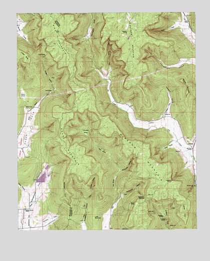
Hollytree, AL USGS Topographic Map
Click on map above to begin viewing in our Map Viewer.

This topographic map contains these locations and features:
Feature Name Type Latitude Longitude GNIS ID View Map
Bice MountainSummitN34.8601°W86.3464°114207View Map
Bingham CemeteryCemeteryN34.7517°W86.2686°114353View Map
Bingham MountainSummitN34.7976°W86.2903°114357View Map
Bingham NarrowsGapN34.7687°W86.2855°114358View Map
Brewer SpringSpringN34.7661°W86.2961°114871View Map
Brooks MountainSummitN34.8293°W86.2558°151701View Map
Bucklight PointCliffN34.7726°W86.3422°115145View Map
Calloway SinksBasinN34.8070°W86.3275°115399View Map
Chalybeate SpringSpringN34.7783°W86.2677°115917View Map
Chalybeate SpringSpringN34.8635°W86.2979°115918View Map
Clear Creek Hunting ClubLocaleN34.7626°W86.3103°139139View Map
Cox SinksBasinN34.7779°W86.3075°116792View Map
Cunningham SinksBasinN34.8670°W86.3236°116974View Map
Dark HollowValleyN34.8745°W86.3242°117080View Map
Davis CemeteryCemeteryN34.7951°W86.2608°117117View Map
Davis CoveBasinN34.7979°W86.2694°117121View Map
Devils DenBasinN34.7601°W86.2789°117253View Map
Dripping SpringSpringN34.7560°W86.2720°117478View Map
Harrison CoveBasinN34.7562°W86.3528°119819View Map
HollytreePopulated PlaceN34.7990°W86.2533°156488View Map
Hollytree CemeteryCemeteryN34.8026°W86.2566°149574View Map
Honey HollowValleyN34.7673°W86.3272°120324View Map
Horton SpringSpringN34.8698°W86.2548°120447View Map
Hurricane Creek Watershed LakeReservoirN34.7863°W86.3545°132047View Map
Jackson SinksBasinN34.7579°W86.2728°120786View Map
Jones CemeteryCemeteryN34.7609°W86.3055°149576View Map
Jones CoveValleyN34.8676°W86.2580°121004View Map
Jones School (historical)SchoolN34.7706°W86.2828°139200View Map
Keel SinksBasinN34.7956°W86.3161°151942View Map
Killingsworth Cove Volunteer Fire Department Station 1BuildingN34.7661°W86.3675°2683004View Map
Little MountainSummitN34.7570°W86.3217°121822View Map
Maples CemeteryCemeteryN34.8167°W86.2716°122271View Map
McFarland HollowValleyN34.7701°W86.3025°122539View Map
Moon CemeteryCemeteryN34.7698°W86.2836°122980View Map
Morring CemeteryCemeteryN34.7745°W86.3639°2061735View Map
Mount Nebo Baptist ChurchChurchN34.7965°W86.2528°123275View Map
Mountain Lake Resort DamDamN34.7784°W86.3567°132046View Map
Padgett (historical)Populated PlaceN34.8195°W86.3064°139244View Map
Patty HollowValleyN34.7718°W86.3683°124501View Map
Pleasant Mount Baptist ChurchChurchN34.7623°W86.3697°153007View Map
Pleasant Mount CemeteryCemeteryN34.7626°W86.3703°157499View Map
Rousseau CemeteryCemeteryN34.7554°W86.3311°149591View Map
Sharp CemeteryCemeteryN34.8198°W86.3661°2062373View Map
Sharp Cemetery Number 2CemeteryN34.8301°W86.3730°2062374View Map
Sharp MountainSummitN34.7993°W86.3411°126640View Map
Sharp SinksBasinN34.8268°W86.3697°126642View Map
Smith LakeReservoirN34.7801°W86.3579°132045View Map
Sneed HollowValleyN34.8309°W86.3489°127072View Map
Sneed SpringSpringN34.8300°W86.3510°127073View Map
Stillhouse HollowValleyN34.7834°W86.3044°127404View Map
The DivideGapN34.8520°W86.3603°127808View Map
Tipton CemeteryCemeteryN34.7565°W86.3166°149597View Map
Todd CemeteryCemeteryN34.8112°W86.2830°128003View Map
Tone CemeteryCemeteryN34.8429°W86.3158°149598View Map
Toney GulfValleyN34.8368°W86.3128°128020View Map
Trenton PointCliffN34.7601°W86.2583°128064View Map
Vaught CoveValleyN34.8154°W86.2700°128429View Map
Williams CreekStreamN34.8087°W86.2717°129020View Map

Note: Coordinates in the location and feature list above are referenced to NAD83 datum.


Copyright (C) 2008-2024 Ryan Niemi / Sunset Dynamics ... All Rights Reserved