TopoQuest Logo
Do you find TopoQuest useful?
Help keep TopoQuest running and adding new maps/features by donating!
Bitcoin:  19c7KJd3qBynnjoSw5npx9KScwjBe4ifkT
Litecoin:  LXs6TkuXGGXo1vDsWCkWVdjQX94eUKd6ui
Home View Maps Find Maps Find Places Resources & Links


Princeton, Alabama Topographic Map

USGS Map Title: Princeton, AL
USGS Map MRC: 34086G2
DRG (GeoTIFF) Download: o34086g2.tif


Neighboring USGS Topographic Map Quads:


  King Cove, AL  
34086H3
 

  Estill Fork, AL  
34086H2
 

  Hytop, AL  
34086H1
 

  Hollytree, AL  
34086G3
 

  Princeton, AL  
34086G2
 

  Mud Creek, AL  
34086G1
 

  Paint Rock, AL  
34086F3
 

  Lim Rock, AL  
34086F2
 

  Scottsboro, AL  
34086F1


Map MRC Location:

N35°
W87°
N35°
W86°
H8 H7 H6 H5 H4 H3 H2 H1
G8 G7 G6 G5 G4 G3 G2 G1
F8 F7 F6 F5 F4 F3 F2 F1
E8 E7 E6 E5 E4 E3 E2 E1
D8 D7 D6 D5 D4 D3 D2 D1
C8 C7 C6 C5 C4 C3 C2 C1
B8 B7 B6 B5 B4 B3 B2 B1
A8 A7 A6 A5 A4 A3 A2 A1
N34°
W87°
N34°
W86°

Princeton, AL USGS 1:24K Topographic Map Preview:
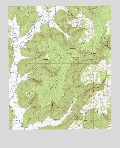
Princeton, AL USGS Topographic Map
Click on map above to begin viewing in our Map Viewer.

This topographic map contains these locations and features:
Feature Name Type Latitude Longitude GNIS ID View Map
BaileytownPopulated PlaceN34.8590°W86.1694°156015View Map
Basham HollowValleyN34.8348°W86.1336°113540View Map
Beachboro (historical)Populated PlaceN34.8529°W86.2078°139093View Map
Beason SpringSpringN34.8391°W86.2439°113704View Map
Bee BranchStreamN34.8290°W86.1383°113795View Map
Big BendCapeN34.8265°W86.1480°114223View Map
Big HollowValleyN34.8234°W86.1394°114287View Map
Bill HollowValleyN34.8451°W86.1789°114341View Map
Black Gum HollowValleyN34.8673°W86.1767°114427View Map
Blessington PointCapeN34.7626°W86.1403°114494View Map
Blue SpringSpringN34.7595°W86.1913°114576View Map
Bouldin PointCapeN34.8698°W86.1647°114764View Map
Brewer HollowValleyN34.8201°W86.1578°114868View Map
Caney HollowValleyN34.8709°W86.1492°115579View Map
Church Hill CemeteryCemeteryN34.8554°W86.2214°116151View Map
Clay CemeteryCemeteryN34.8473°W86.2450°116198View Map
Cowan HollowValleyN34.8337°W86.2319°116753View Map
Dry CreekStreamN34.7829°W86.2464°117594View Map
Eddy CoveValleyN34.8584°W86.2428°117851View Map
Fork MountainSummitN34.8109°W86.1491°118504View Map
Fork Mountain MineMineN34.7979°W86.1514°139169View Map
Fowler CemeteryCemeteryN34.8459°W86.1750°118568View Map
Fowler CoveValleyN34.8590°W86.2017°118570View Map
Fowler NarrowsGapN34.8312°W86.1689°118573View Map
Frazier CoveValleyN34.7668°W86.2347°118610View Map
Graham CemeteryCemeteryN34.8537°W86.2119°119214View Map
Graham CoveValleyN34.8193°W86.2375°119215View Map
Green CemeteryCemeteryN34.8740°W86.2166°119335View Map
Guess Creek ChurchChurchN34.7581°W86.2086°119452View Map
Guess Creek School (historical)SchoolN34.7604°W86.1886°139178View Map
Holly Grove ChurchChurchN34.8440°W86.2392°1959049View Map
Horseshoe BendCapeN34.8412°W86.1322°120424View Map
Hunter HollowValleyN34.7598°W86.2047°151824View Map
Indian Grave PondLakeN34.8269°W86.1798°120657View Map
Jacobs MineMineN34.7790°W86.1980°1700439View Map
Jacobs Mine Number 2MineN34.7743°W86.2172°139198View Map
Jacobs MountainSummitN34.8143°W86.1844°120795View Map
Larkin ForkStreamN34.8623°W86.2100°154468View Map
Larkin Fork Post OfficePost OfficeN34.8723°W86.2055°169277View Map
Larkins Fork (historical)Populated PlaceN34.8723°W86.2055°166088View Map
Latham CemeteryCemeteryN34.7654°W86.1805°121407View Map
Latham NarrowsGapN34.7587°W86.1594°121409View Map
LetcherPopulated PlaceN34.7520°W86.1622°121507View Map
Lick ForkStreamN34.8348°W86.2386°121599View Map
Little NashvillePopulated PlaceN34.7529°W86.2311°156615View Map
Little Nashville PointCapeN34.7629°W86.2233°121830View Map
Logan PointCapeN34.8434°W86.2019°121966View Map
Mill CreekStreamN34.8354°W86.1311°122799View Map
Mount Zion ChurchChurchN34.8384°W86.2489°165147View Map
Mountain View Baptist ChurchChurchN34.8506°W86.1464°154514View Map
Neely BranchStreamN34.8348°W86.1333°123678View Map
Paint Rock Valley High SchoolSchoolN34.8434°W86.2439°139245View Map
Pole BranchStreamN34.7795°W86.1711°125086View Map
Poplar HollowValleyN34.8170°W86.1650°125150View Map
Prince CemeteryCemeteryN34.8598°W86.1625°125283View Map
PrincetonPopulated PlaceN34.8434°W86.2430°153067View Map
Princeton ChurchChurchN34.8348°W86.2464°153068View Map
Princeton DivisionCivilN34.8669°W86.2182°165809View Map
Princeton Post OfficePost OfficeN34.8431°W86.2433°2788969View Map
Robertson CoveValleyN34.8737°W86.1869°125707View Map
Robertson SpringSpringN34.7691°W86.2451°125710View Map
Round KnobSummitN34.8148°W86.2292°125972View Map
Rouse CemeteryCemeteryN34.8026°W86.2386°149593View Map
Rutledge PointCapeN34.8031°W86.2139°126058View Map
Salt Peter HollowValleyN34.7729°W86.2236°139273View Map
Saltpeter CoveValleyN34.8015°W86.2286°126275View Map
Sampson PointCapeN34.8287°W86.2133°126286View Map
Sand BluffCliffN34.8618°W86.1769°126295View Map
Shop HollowValleyN34.7668°W86.1750°126804View Map
Skyline Volunteer Fire Department Station 2BuildingN34.7522°W86.1622°2683430View Map
Skyline Volunteer Fire Department Station 3BuildingN34.8574°W86.1499°2683447View Map
Slipoff HollowValleyN34.7912°W86.1708°126974View Map
Stovall HollowValleyN34.8515°W86.2144°127444View Map
SwaimPopulated PlaceN34.8695°W86.1983°157133View Map
Thompson CoveValleyN34.8420°W86.2444°127902View Map
Threwer PointCapeN34.7873°W86.2236°127953View Map
Valley Volunteer Fire Department Station 1BuildingN34.8434°W86.2425°2683433View Map
Williams CoveValleyN34.7948°W86.2394°129014View Map
Williams Cove ChurchChurchN34.8029°W86.2278°153994View Map
Winding StairsCliffN34.8215°W86.2022°129110View Map

Note: Coordinates in the location and feature list above are referenced to NAD83 datum.


Copyright (C) 2008-2024 Ryan Niemi / Sunset Dynamics ... All Rights Reserved