TopoQuest Logo
Do you find TopoQuest useful?
Help keep TopoQuest running and adding new maps/features by donating!
Bitcoin:  19c7KJd3qBynnjoSw5npx9KScwjBe4ifkT
Litecoin:  LXs6TkuXGGXo1vDsWCkWVdjQX94eUKd6ui
Home View Maps Find Maps Find Places Resources & Links


Janesville East, Wisconsin Topographic Map

USGS Map Title: Janesville East, WI
USGS Map MRC: 42088F8
DRG (GeoTIFF) Download: o42088f8.tif


Neighboring USGS Topographic Map Quads:


  Edgerton, WI  
42089G1
 

  Milton, WI  
42088G8
 

  Lima Center, WI  
42088G7
 

  Janesville West, WI  
42089F1
 

  Janesville East, WI  
42088F8
 

  Avalon, WI  
42088F7
 

  Beloit, WI  
42089E1
 

  Shopiere, WI  
42088E8
 

  Clinton, WI  
42088E7


Map MRC Location:

N43°
W89°
N43°
W88°
H8 H7 H6 H5 H4 H3 H2 H1
G8 G7 G6 G5 G4 G3 G2 G1
F8 F7 F6 F5 F4 F3 F2 F1
E8 E7 E6 E5 E4 E3 E2 E1
D8 D7 D6 D5 D4 D3 D2 D1
C8 C7 C6 C5 C4 C3 C2 C1
B8 B7 B6 B5 B4 B3 B2 B1
A8 A7 A6 A5 A4 A3 A2 A1
N42°
W89°
N42°
W88°

Janesville East, WI USGS 1:24K Topographic Map Preview:
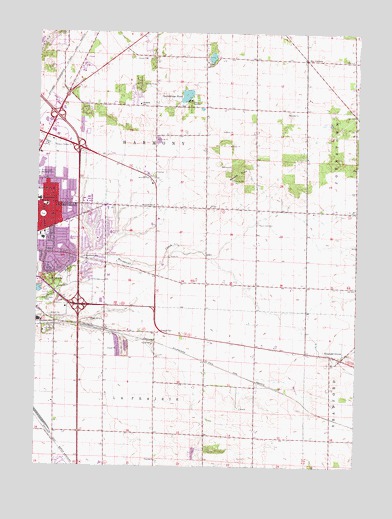
Janesville East, WI USGS Topographic Map
Click on map above to begin viewing in our Map Viewer.

This topographic map contains these locations and features:
Feature Name Type Latitude Longitude GNIS ID View Map
Ardon ParkParkN42.7117°W88.9954°1833923View Map
Bethel Baptist ChurchChurchN42.7000°W88.9790°1833938View Map
Bjoin QuarryMineN42.6289°W88.9400°2633468View Map
Blackhawk CreekStreamN42.6858°W88.9773°1561897View Map
Blackhawk Golf CourseLocaleN42.7083°W88.9968°1833940View Map
Blackhawk Meadows ParkParkN42.6820°W88.9890°1833941View Map
Blackhawk ParkParkN42.6725°W88.9943°1561900View Map
Blackhawk SchoolSchoolN42.6853°W88.9815°1561901View Map
Camp RotamerLocaleN42.7303°W88.9393°1562653View Map
Cargill United Methodist ChurchChurchN42.6906°W88.9979°1833946View Map
Christ Presbyterian ChurchChurchN42.6858°W88.9732°1833956View Map
Emerald GrovePopulated PlaceN42.6561°W88.8807°1564611View Map
Emerald Grove CemeteryCemeteryN42.6546°W88.8858°2768075View Map
Emmanuel Free Methodist ChurchChurchN42.7006°W88.9904°1833990View Map
Exit 177CrossingN42.6347°W88.9826°1833998View Map
Georgetown ParkParkN42.7067°W88.9901°1834035View Map
Good Shepherd Lutheran ChurchChurchN42.6906°W88.9732°1834037View Map
Hacklander AirportAirportN42.6537°W88.8926°2717086View Map
Hampshire ParkParkN42.6811°W88.9779°1834044View Map
Harmony Elementary SchoolSchoolN42.7294°W88.9608°1566076View Map
Harrison Elementary SchoolSchoolN42.6921°W88.9714°1566097View Map
Hawthorne ParkParkN42.6972°W88.9979°1834048View Map
Howarth SchoolSchoolN42.7006°W88.9543°1566771View Map
Huron ParkParkN42.6881°W88.9912°1834054View Map
Interchange 171CrossingN42.7261°W88.9929°1834055View Map
Interchange 175CrossingN42.6714°W88.9834°1834056View Map
Jackman ParkParkN42.6920°W88.9859°1834059View Map
Janesville Fire Department Station 4BuildingN42.7003°W88.9640°1834008View Map
Janesville Mall Shopping CenterLocaleN42.7117°W88.9987°1834064View Map
Janesville Medical CenterHospitalN42.6989°W88.9746°1834065View Map
Janesville Virtual AcademySchoolN42.7018°W88.9989°2716160View Map
Jefferson Elementary SchoolSchoolN42.7017°W88.9989°1567116View Map
Kennedy Elementary SchoolSchoolN42.7076°W88.9674°2716245View Map
LaPrairie ParkParkN42.6642°W88.9951°1567697View Map
Mandale ParkParkN42.7031°W88.9868°1834082View Map
Marshall Middle SchoolSchoolN42.6927°W88.9867°2716459View Map
Monroe Elementary SchoolSchoolN42.6904°W88.9868°1834111View Map
Mount ZionSummitN42.7092°W88.9212°1569862View Map
Mount Zion CemeteryCemeteryN42.6951°W88.9141°1569863View Map
Mount Zion United Methodist ChurchChurchN42.7003°W88.9962°1834114View Map
O'Leary FarmsLocaleN42.7311°W88.8939°2632175View Map
Palmer ParkParkN42.6781°W88.9929°1571000View Map
Rock Prairie Montessori SchoolSchoolN42.7277°W88.9411°2716320View Map
Ruger ParkParkN42.6853°W88.9954°1834151View Map
Saint Marks Lutheran ChurchChurchN42.7008°W88.9851°1834166View Map
Saturn ParkParkN42.7306°W88.9607°1834183View Map
Six CornersLocaleN42.7425°W88.8951°1574214View Map
Spauldings PondLakeN42.7319°W88.9423°1574520View Map
Town of HarmonyCivilN42.7203°W88.9354°1583351View Map
Town of La PrairieCivilN42.6258°W88.9509°1583530View Map
United ChurchChurchN42.6989°W88.8751°1575920View Map
Venable FarmsLocaleN42.6778°W88.8761°2546797View Map
Woodland Christian SchoolSchoolN42.7424°W88.9587°2716510View Map

Note: Coordinates in the location and feature list above are referenced to NAD83 datum.


Copyright (C) 2008-2024 Ryan Niemi / Sunset Dynamics ... All Rights Reserved